Trekking en Zillertal Alps: la Zillertal Rucksack Route (o Berliner Hoehen Weg) y la Zillertal South Tyrol Tour en el Tirol austriaco
![Trekking en Zillertal Alps / Foto: Hejkal [CC BY-SA 3.0] Wikimedia Commons](https://travesiapirenaica.b-cdn.net/wp-content/uploads/2015/08/Trekking-en-Zillertal-Alps_by-Hejkal-CC-BY-SA-3.0-Wikimedia-Commons_1200x900.jpg)
Pirineos y montaña 📩
Aquí 🔥Pocas zonas pueden igualar al Zillertal, en el Tirol austriaco, en una primera temporada alpina. Picos bien formados, buenos senderos y algunas de las mejores cabañas de los Alpes lo hacen ideal tanto para excursionistas experimentados como para montañeros.
Encontramos dos rutas clásicas de cabaña a cabaña, ambas se pueden realizar en ocho a diez días, con la opción de agregar excursiones de un día desde las cabañas para escalar picos locales a ambos lados de la frontera, incluyendo la cumbre más alta de Zillertal, el Hochfeiler.
Guía práctica
¿Cuándo ir?
La nieve puede persistir en las laderas orientadas al norte hasta bien entrado el mes de julio. De mediados de julio a mediados de septiembre es más cálido y está más asentado. La temporada alpina de verano comienza cuando las cabañas abren desde mediados de junio hasta finales de septiembre.
Ciudades & Servicios
A Zillertal se accede fácilmente en tren y autobús desde Jenbach a través de Munich, Innsbruck y Salzburgo, hasta la encantadora ciudad turística de Mayrhofen, el centro principal y punto de partida para hacer senderismo en el Zillertal. Fácil acceso a las rutas desde Mayrhofen.
No puedes perderte
- Zillertal Rucksack Route Hohenweg
- Tour del Tirol del Sur.
- Paisajes fabulosos en el corazón del Tirol austriaco y de los Alpes Orientales
La Zillertal Rucksack Route (ZRR) o Berliner Hoehen Weg
La ZRR recorre 70-80km y salva 6700m desnivel, enlazando ocho cabañas sin cruzar glaciares ni pasos difíciles, con amplias posibilidades de escalar los picos cercanos. Ello no quiere decir que no discurra por terreno escarpado (con uso de cables de acero fijo instalados para facilitar la seguridad) y tengamos que encontrarnos con la nieve, dependiendo de la temporada. Comienza sobre Mayrhofen y sigue una ruta circular que termina en lo alto del encantador pueblo de Ginzling.
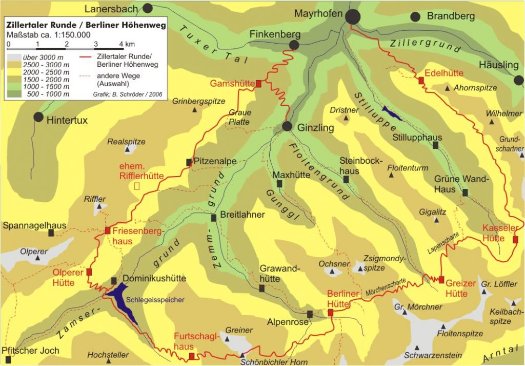
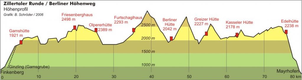
Las etapas
- Etapa 1 Mayrhofen a la cabaña Karl von Edel (posibilidad de realizar ascensión al Ahorn Spitze)
- Etapa 2 Cabaña Karl von Edel a la cabaña Kasseler (posibilidad ascesnión Woellbach Spitze y ascensión al Grune Wand Spitze)
- Etapa 3 Cabaña Kasseler a la cabaña Greizer (ascensión (Grosser Loeffler)
- Etapa 4 Cabaña Greizer a la cabaña Berliner
- Etapa 4a Cabaña Greizer a cabaña Berliner por el glaciar Floitenkees o cabaña Schwarzenstein (ascensión Berliner Spitze-Horn Spitze III-)
- Etapa 5 Cabaña Berliner a la Furtschagl Haus (Grosser Moseler por la west spur)
- Etapa 6 Furtschagl Haus a la cabaña Olperer
- Etapa 6a Furtschagl Haus a la cabaña Olperer por Pfitscherjoch Haus (posibilidad ascensión Olperer)
- Etapa 7 Cabaña Olperer a Friesenberg Haus (posibilidad ascensiones Hoeher Riffler y Peterskopfl)
- Etapa 8 Friesenberg Haus a la cabaña Gams (posibilidad ascensión Vorderer Grindberg Spitze)
- Etapa 9 Cabaña Gams a Mayrhofen
La Zillertal South Tyrol Tour (ZSTT)
El Zillertal South Tyrol Tour atraviesa toda la cordillera a lo largo de la frontera austro-italiana, comenzando en Turistenraste y luego enlazando de nuevo con la Zillertal Rucksack Route (ZRR) para hacer un tour circular. Es prácticamente desconocida fuera del Tirol del Sur, lo que la convierte en una ruta interesante e inusual. Es un trekking físicamente exigente, proporcionando un excelente desafío para los caminantes alpinos más experimentados.
Las etapas
- Etapa 1 Touristenraste a la cabaña Geraer
- Etapa 2 Cabaña Geraer a Pfitscherjoch Haus
- Etapa 3 Pfitscherjoch Haus a la cabaña Hochfeiler (posibilidad ascensión Hochfeiler)
- Etapa 4 Cabaña Hochfeiler a la cabaña Edelraute
- Etapa 5 Cabaña Edelraute a la cabaña Nevesjoch (Ascensión Grosser Moseler)
- Etapa 6 Cabaña Nevesjoch a la cabaña Schwarzenstein
- Etapa 7 Cabaña Schwarzenstein a la cabaña Berliner o la cabaña Greizer