Stage 44: Requesens - Vilamaniscle


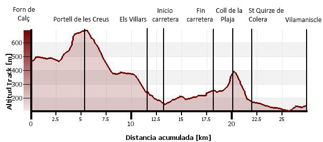
(0h00min; 0 kms) Requesens (504m). Parking zone, livestock pens, La Mare de Déu church, Can Seferino and “La Cantina”. Walk down the track while enjoying the views over Requessen castle. You pass the Fuente del Ferro (drinkable) and come to a track that you leave just a few metres further down on the next bend, by the Forn de Totxos. The path heads down until it crosses a stream, then it passes another stream before taking on a short climb to a crossing. The GR continues along a wall, which you leave on the right. Hidden in the woods, on the left, lies the...
(0h30min; 2 kms) Refugio del Forn de Calç (467m). The walk continues through dense evergreen oak woodland. Some 40 minutes later, you pass the ruins of Mas de Mirapols, then shortly afterwards you cross a stream, Còrrec de la Jaça, and a little further on you pass another one, Rec de Mirapols, where you can also fill up with water. The path gets steeper from now on, and as you gain height, beech (the easternmost in the peninsula), holly and oak trees among others, begin to appear. When you have almost reached the top, you leave a connecting route to the GR10 and come out into open countryside. Pass the Coll de la Llosarda (689m) and walk on to the...
(2h00min; 7,3 kms) Portell de les Creus (699m), between the Puig del Mig (735m) and the Puig de les Rouredes (721m). Cross the barbed-wire fence on the left and begin the descent. You quickly come to a track that drops sharply down to Els Villars. Along the way you pass several drinking fountains – all dry in summer – as well as a few dolmens, which are to be found in abundance in this area.
(3h20min; 13,7 kms) Els Villars (237m). In Els Villars there is a drinking fountain at the other end of the village, at the exit to Espolla. To continue along the GR11 you need to turn left as soon as you reach the village and head down an embankment. The GR11 drops down to a stream, which you cross a couple of times, before coming to a beaten-up road by the Font de Cadecàs (the water here is yellow). Follow the road left until you reach the...
(3h50min; 15,2 kms) Col de Banyuls road (156m). Follow the tarmac road for 5 kilometres to...
(5h00min; 20,2 kms) Mas Pils (258m). Turn on to a track that appears on the right, and half-way up you take a shortcut that passes a couple of drinking fountains. Close to the top, you rejoin the track.
(5h35min; 22,2 kms) Coll de la Plaja (392m). You walk down the track, while taking the available shortcuts.
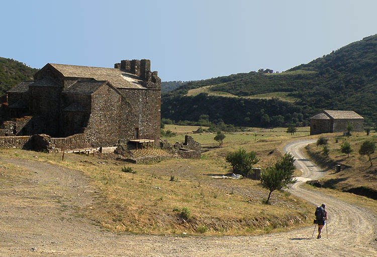
(5h35min; 23,8 kms) Sant Quirze de Colera (180m). In Sant Quirze, apart from the Benedictine monastery, there is a bar. It is worth mentioning that this area has been declared a Natural Space of National Interest and is a reserve for the Hermann’s Tortoise. Keep walking down the track (you pass a dry water outlet), which soon becomes a tarmac road, leading to...
(6h55min; 27,6 kms) Carretera Vilamaniscle - Rabós (106m). Turn left and follow the road to...
(7h20min; 29,4 kms) Vilamaniscle (152m). Drinking fountain.
At the beginning of the stage, in vecindario de Requesens Alojamientos rurales de Requesens (34 646 179 509; info@fincaderequesens.cat; See map). Next to La Cantina (restaurant), it has a kitchen and a fireplace. Contact in advance.
Two kilometres from Requesens, along the GR11, is the Refugi del Forn de Calç (acceptable condition, for around 10 people, "inhabited by the odd mouse").
Off the route, in Espolla, 2kms from Els Villars: Vilars 10.
In Vilamaniscle, Mas Vivent. For large groups Casa Colonias Tramuntana. Below the swimming pools, an area for wild camping has been made available for walkers.
At the end of the stage, in Delfià, on the road between Rabós and Garriguela (5km diversion from the crossroads between Rabós and Vilamaniscle or 3kms by track from Vilamaniscle), we recommend Can Jenot (Tel: +34 672 208 690; lorenaca1000@hotmail.com). It has two apartments for 2 and 4 people, a swimming pool, washing-machine, internet, cooker and fridge...The price per person is 40€ (minimum 2 people) and 30€ more with breakfast and dinner included. The minimum stay is two nights. In July and August, it is only available for the whole week. Book in advance and confirm via phone. It is located in Delfià on the road between Rabós and Garriguela. If you so wish, they will come and pick you up in Sant Quirze or Vilamaniscle... for no extra charge. To get to the intersection of the road from Sant Quirze de Colera with the one from Rabós to Vilamaniscle on foot, there are two options: By road (5kms), passing Rabós and afterwards towards Garriguela de Baix, or an easy route via track (3kms). Follow the road towards Vilamaniscle for about 700m until a track emerges on the right, which brings you directly to Can Jenot. You just need to follow the main path (0.1kms ahead, 0.3kms right, 2kms right, 2.3kms ahead). See map.
Where to eat:In Requesens, you have La Cantina (//) (delicious salads, salamis, canelloni, grilled meat with aioli and typical desserts). You are recommended to book in advance.
Other services:In Sant Quirze de Colera there is a bar (Tel.: 972 19 31 86; open from 9:00 to 17:00, closed on Wednesdays).
In Vilamaniscle there is a municipal swimming-pool with a bar.
