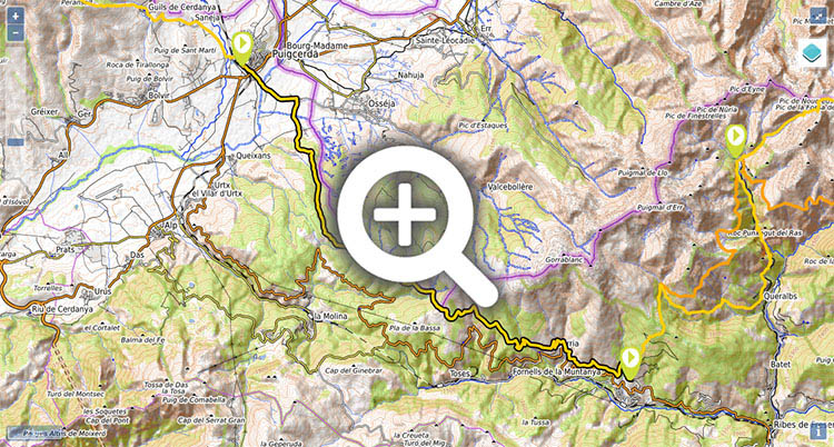
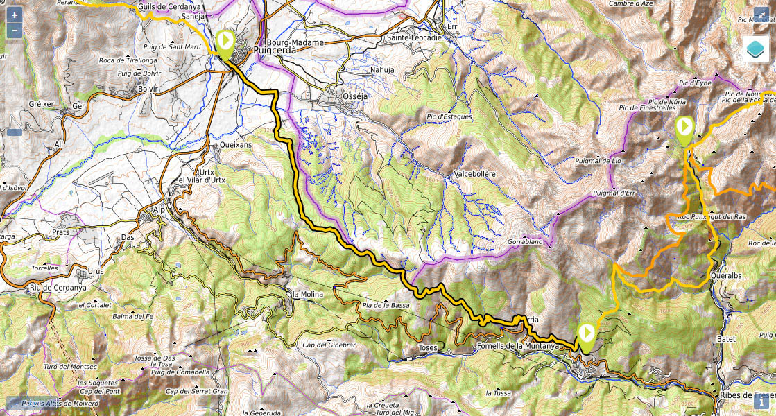
Stage 36: Puigcerdà - Planoles.

(0h00min; 0 kms) Puigcerdà (1.155m). Your starting point is the train station square. The GR11 goes along Avenida dels Pirineus and then follows the road to Vilallobent as far as the N-152 road. Cross the road and continue walking along the Camí d'Age until you come to Carrer Puigcerda, a narrow road that you follow all the way to...
(0h35min; 2,4 kms) Age (1.140m). You can either turn right just before Age or left into the village. If you head into the village, about half way, there is a street to the left (Carrer Font) where you will find a drinking fountain after 50m. At the end of the village, turn left and follow the road to Vilallobent.
(0h55min; 3,9 kms) Vilallovent (1.170m). Drinking fountain in the Plaza Mayor. Leave the village on the left and take a track going in a southerly direction. Shortly after passing the last houses, leave the track and follow a path on the left (shortcut). After 10mins you join a track that springs from another track coming from Villobent, which you follow east. After 1km the track forks (right) and almost two kilometres later you take a path on the right – following the track 0.6km you would reach Vilallobent refuge - .Walk up the path for 1km, until it joins a track at a junction. Keep left (south east) and head up the track for 2kms until you leave it on a bend on the right, to reach a small grassy valley ahead. At the top you come to an area of clearings (de la Basseta) where the track comes to an end and on a small hillock you can find the border stone 500.
(2h55min; 11,2 kms) Raso de la Basseta - Mojón 500 (1.980m). This area can be confusing in foggy conditions. Head south-east to a track that starts 200m away on the edge of the trees and follow it through the forest while sticking to the border. The track soon gives way to a path. You pass a stream (it might be dry) and further ahead you pass another one (this time with a better chance of finding water). The path gives way to a track, and you climb uphill to another area of open grasslands at the...
(3h45min; 14,7 kms) Coll de la Creu de Meians (1.990m). From here you could reach Nuria – an extremely tough day’s walking – following the ridge to the east, crowned by Puigmal mountain (2,911m). Keep east, and head down to the right (south) across a small valley where you will find water until you come to a track. Follow it on the left until shortly after a junction. Ignore the track on the right on a hairpin bend and just afterwards, take a path that runs parallel to the track below for 1km (follow the path or the track). Before you come to the track, you will pass a stream. From now on you will follow the track (apart from a couple of shortcuts) until you reach...
(5h35min; 21,5 kms) Dòrria (1.520m), the highest village in Catalonia. The GR11 leaves Dòrria below on the right and follows the track straight ahead, then turns and returns to the village (taking a shortcut through the village to take water from the drinking fountainnext to the wash house is a good option). At the end of the village, where the road begins, there is a path that heads down in a northerly direction, then continues along the hillside to the east. Follow it for 4kms to a junction, where if you take the right fork you go down to Planoles, and if you go up and left, you will reach the campsite (1km) and the GR11. Keeping left, you pass a stream after 500m and another 500m later you will come to a junction, where you keep left (right to the campsite), which is the starting point of the climb and the next stage.
(7h05min; 27,5 kms) Planoles - Start of the climb (1.260m).
In Puigcerdà there is a choice of accommodation. We recommend Hostal Fonda Prat ((+34) 675 629 882 / (+34) 637 972 165; hola@fondaprat.com). Next to the GR11. It is very clean and homely, and also has a living room, a dining room, an equipped kitchen for the use of guests and free wifi.
At the end of the stage: Camping Can Fosses. In Planoles, Cal Sadurní and Hotel Cruells.
Other services:In Puigcerdà you will find everything you need.
In Planoles you will find a food store and the odd bar/restaurant.
Transport:To get to Puigcerdà, the bus company Alsa provides 2 bus routes: Puigcerdà-La Seu d’Urgell-Lleida and Llívia-Puigcerdà-Barcelona.
Also, Puigcerdà and Planoles are connected on the Puigcerdà-Girona bus line Autobuses Teisa (/) and by train, by the line Barcelona-Vic-Ripoll-Ribes de Freser-Planoles-La Molina-Puigcerdà-La Tor de Querol (RENFE).
TYou can also get to Planoles by bus from Ripoll courtesy of the company Autocars Mir (/).


En la carretera entre Puigcerdà y Age.

Subiendo al primer collado del día, Coma del Fang / Pla de les Forques.

Subiendo al Ras de la Basseta

junto a Brian, autor de la guía Cizerone.