5 natural destinations in the southwest of the peninsula

Pyrenees and mountains 📩
Here 🔥The southwest of the Iberian Peninsula treasures a geography that hides incredible places, natural wonders, many of which have yet to be discovered by the general public.
In this mini-report we propose 5 nature destinations that may inspire you to prepare a weekend or multi-day trip. This is an ideal time to visit the area, the dehesas are green, the chestnut groves are dressed in autumn, the peaks are snow-capped and, almost more importantly, we are safe from the rigours of summer. There is only one problem, which one to start with.
Cerro del Hierro

The Sierra Norte de Sevilla is a fairly unknown area above Despeñaperros. The first thing that strikes the outsider visiting this area for the first time is the freshness of the landscape and the intense greenery of the extensive and well-preserved dehesa.
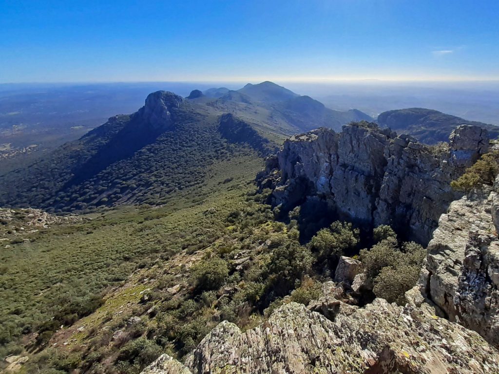
The Sierra Norte de Sevilla Natural Park was declared a natural area in 1989. In 2002 it was included by UNESCO in the Biosphere Reserve "Dehesas de Sierra Morena" and declared a Geopark in 2011. Inside is the Cerro del Hierro Natural Monument, something truly crazy. It is a karst 500 million years old. A landscape dotted with hundreds of needles arranged in a totally anarchic way. To enter this labyrinth, we can follow a fully signposted path that winds through rock corridors and tunnels into the interior of what used to be an old mining operation, abandoned in 1985. This is where the iron was used to build the Triana Bridge. We recommend that you take a torch and stay on the marked paths due to the danger of landslides.
Years after the abandonment of mining, whose origins date back to Roman times, Sevillian climbers set their sights on this place and began to equip the first sectors. Although at the end of the 1990s and in subsequent years, the school went through a period of abandonment, today it is once again the leading climbing school in the province. The routes, around 180, are short, up to 25 metres, most of them between V and 6C, with a predominance of slabs. If you plan to go climbing, it may be necessary to ask for permission in some sectors.
Nearby it is worth visiting the Huéznar waterfalls, walking or cycling the 18 kilometres of the Sierra Norte de Sevilla greenway and visiting the numerous geosites throughout the Geopark.
Sierra Grande de Hornachos
The Sierra Grande de Hornachos, located in the centre of the province of Badajoz, between the regions of La Serena, Campiña Sur and Tierra de Barros, represents the highest relief of the latter, to which it belongs.
The Sierra Grande de Hornachos stands out prominently in a practically flat area of rolling hills, like a green island with an abrupt relief. At its feet lies the Tierra de Barros, an agricultural region par excellence, with fertile soil, famous for the mud that forms when it rains and where vineyards and traditional olive groves predominate.
The Sierra Grande de Hornachos is named after the town of Hornachos, a place worth visiting to discover its heritage and its history. Although its origins seem to lie in a Roman settlement, some authors suggest that it was founded in an earlier period. The Roman road that crosses the sierra dates back to this period. The most important period of the village was during the modern age, until the expulsion of the Moors in the 17th century. Of those settlers who were forced to leave Hornachos, many ended up in Salé, which later became Rabat. Continued differences with the more traditional local population led to continuous clashes that ended with the declaration of the Republic of Salé, a pirate state of corsairs whose main target was Spanish ships.
Back in the Sierra de Hornachos, we recommend you take one of the signposted routes through the sierra. You can climb up to the castle, discover the numerous Roman and Muslim remains, go in search of cave paintings, cross to the other side of the sierra, to the shady area, or climb up to the Peñón de Marín (943m) to contemplate the immense views from its summit, the envy of other much higher peaks.
The town council proposes these five routes of medium-low difficulty: Camino de las Hachas, Ruta de los Escalones or del Carrascal, Ruta de la Sierra de Pinos, Camino de la Umbría and a monumental route through the historic centre.
The Raya: Serra de São Mamede N.P. and Serra Fria.
The Raya or A Raia is the border area that stretches between Spain and Portugal for 1,200 kilometres. It is the oldest border in Europe, with more than seven centuries of history, and although today it is an area of cultural exchange with populations on both sides sharing historical, cultural and economic elements, in the past it was a powder keg, an area of constant confrontation.
From a natural point of view, the Raya is a corridor in which we find natural spaces of the first order such as the Sierra de la Culebra, the Arribes del Duero or the Tajo Internacional Natural Park. Just here, to the south of this cross-border cooperation area with several Z.E.P.A. zones, we find the Serra de São Mamede Natural Park and the Serra Fria, a branch of which acts as a natural border.
We suggest you start your visit on the Spanish side, in the municipality of Valencia de Alcantara in Cáceres, the place in Western Europe with the highest concentration of megalithic monuments. The dolmens, declared an Asset of National Cultural Interest, can be visited. We recommend you take the route that starts at La Aceña de la Borrega, where, as well as discovering several of these monuments, you will visit a magnificent granite landscape of craggy rock and Mediterranean forest.
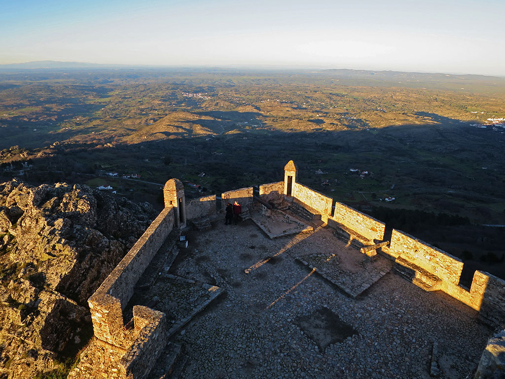
The next stop is Marvão, but climbers can make a stop on the way and stop at the Puerto Roque climbing area. A climbing school in quartzite rock, formed by ridges of typical Appalachian relief. Arriving at the village of Marvão is not like arriving at any other place. The village is completely walled, on the top of a hill over 800 metres high and with a castle at its highest point from where you can see the whole Tagus International Natural Park and our next objective, the Serra de São Mamede.
The peak of São Mamede (1,025m), in the mountain range of the same name, is the highest point in Portugal south of the Tagus River. The views, as you can imagine, are endless. We recommend the ascent by bicycle on a rough road to the antennae, the last kilometre of which has ramps of 18%. The whole area is highly recommended for mountain biking or road cycling, with its almost deserted, traffic-free roads. The slopes of the sierra are covered by lush forests with an abundance of pine, oak, chestnut, cork and holm oak trees. The presence of ferns will make you think you are somewhere in the north of the peninsula.
Sierra de Grazalema
The Sierra de Grazalema, in the northeast of the province of Cádiz, is the habitat of the Spanish fir. A type of fir tree found only in this mountain range, and to a lesser extent, in the nearby Sierra de las Nieves and Sierra Bermeja, as well as a small redoubt in the north of Morocco. It was precisely the presence of this botanical jewel, which today we only find here, but which millions of years ago occupied large areas of the European continent, that led to the declaration of these sierras as a Biosphere Reserve and Natural Park.
The best way to get to know the sierra is on foot. Many of the trails can be walked all year round, however, to access some areas it is necessary to apply for a permit at the visitor centre in the village of El Bosque or by contacting them by phone or email.
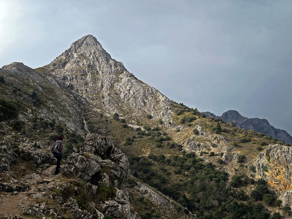
The four trails for which you need to ask permission are highly recommended for a first contact with the park. They are the Pinsapar trail, the ascent to the Torreón, the Garganta Verde trail and the Llanos de Rabel trail.
The Pinsapar trail enters the northern face of the Sierra del Pinar, where the largest area of Spanish firs is found, some 400 hectares. The route to the Torreón climbs up to the highest peak in the sierra and in the province of Cádiz. If you want to climb up the ridge from Pico San Cristobal, you will need to ask for an additional special permit. The Garganta Verde trail descends into a spectacular canyon carved out by the Bocaleones stream. The most spectacular point is at the end of the walking section, at the Cueva de la Ermita. The Llanos de Rabel trail is the easiest of the four. It enters the Reserve Zone, where the Spanish fir forest begins. This route offers impressive views of the north face of the Sierra del Pinar on the approach.
In addition to these four routes and many others that are well worth a visit, a visit to the Sierra de Grazalema would be incomplete without a visit to the white villages, so called because of the white lime used on their façades to repel the summer heat.
Villuercas Ibores Jara Geopark
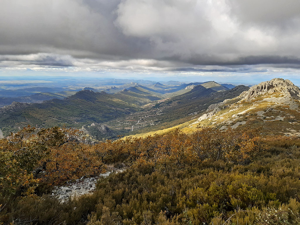
A geopark or geological park is a territory that presents a remarkable geological heritage and carries out a development project based on its tourist promotion. The Unesco Global Geopark Villuercas - Ibores - Jara more than meets these requirements. It is a mountain massif located in the southeast of the province of Cáceres, within the so-called Montes de Toledo, with its highest point at Risco de la Villuerca (1,601m).
The summit of the Risco de la Villuerca is an unbeatable place for the interpretation of this mountain system surrounded by ancient peneplains and made up of a series of mountain ranges and valleys aligned in a parallel northwest-southeast direction. The boxing in of the current fluvial network has configured the main geomorphological characteristic of the region, the so-called Appalachian relief, by analogy with the Appalachian Mountains of North America, and which here in Europe has its greatest example in the Villuercas.
Having made the introductions, we recommend that you visit one of the geopark's information centres. Here you can get advice on routes, events and brochures with detailed information on how to visit the 50 geosites catalogued by the Geopark.
The official website of the Geopark has drawn up a list of "top 10 geosites" made up of: the Risco de la Villuerca, the Castillo de Cabañas and the Santa Lucía Syncline, the Peña Amarilla Strait, the Castañar de Ibor Cave, the Pedroso Gorge, the Ruecas Gorge, the Chorrera and the Calabazas Chestnut Trees, the Cancho de las Sabanas, the Risco Carbonero and the Costanaza Mine.
Finally, don't miss the opportunity to visit the Royal Monastery of Guadalupe or take a stroll through the chestnut and oak forests around the town of Castañar de Ibór, especially in autumn. If you are a cycling enthusiast, the climb to the Risco de la Villuerca is a tough one, and you will probably remember it from the Vuelta a España 2021.
Fastpacking is not about going faster. It's about going lighter.
If you come from classic trekking, this is the next step: learning to move with less weight,
more fluid and enjoying every kilometre more.
Join the Outsiders Newsletter and start discovering what lightness feels like.