Weather warnings, alerts, GAP and some recommendations in the mountains
One of the greatest risks for those of us who practise mountain activities is adverse weather conditions. Nowhere else as in the mountains are the weather phenomena so extreme and at the same time so changeable.
For this reason, the mountaineer should have some knowledge of meteorology, be observant of the evolution of the weather throughout the day, consult the latest forecast and the avalanche danger bulletin (BPA) if it is the case.
It is the latter, consulting the weather forecast and the avalanche report, that we are going to talk about in this article, or more specifically, the weather warnings and the BPA.
Differences between weather warnings and alerts.
It is often the case that the meaning of weather warnings and alerts are confused, the difference is quite simple.
Weather warnings: when we talk about weather warnings, we have to refer to the National Plan for the Prediction and Monitoring of Adverse Weather Events (Plan Nacional de Predicción y Vigilancia de Fenómenos Meteorológicos Adversos (Meteoalert). The warnings refer to a specific adverse weather phenomenon (rain, snowfall, wind...) that may affect Spain for up to 60 hours. They are classified by colour (green, yellow, orange and red). They are objective, i.e. they are based on threshold values established with climatological criteria. More on these threshold values later. Weather warnings are issued by AEMET and can be consulted at AEMET > Weather > Weather > Forecast > Weather warnings.
Alerts: alerts, on the other hand, are decreed by the administration (national, regional, insular and local) and although they are related to warnings, they do not always go hand in hand. Alerts are not based on objective threshold values like warnings, but are based on the risk they pose to the population. The AEMET gives this example: an orange warning can be issued for strong winds at an altitude of more than 1,400 metres and the administration does not issue an alert because it understands that at that altitude it does not affect the population. The different states of alert are:
- Pre-alert status: it is an internal state to warn all actors involved in civil protection. They are not made public and therefore do not affect the population.
- Alertness: informs the population of a specific risk and provides information on a series of specific recommendations. They can be by zones or for the whole of the national territory.
- State of high alert: is the highest level of alertness. It usually involves making decisions that affect people's daily lives.
Meteorological phenomena to consider in the mountains
Although the meteorological phenomena that give rise to warnings are some more (coastal, dust in suspension...), the ones that interest us, in the case of mountain activities and adventure sports, are the following:
- Rainfall
- Snowfall
- Winds
- Storms
- Maximum temperatures
- Minimum temperatures
- Avalanches
- Thawing
Thresholds and warning levels
The thresholds are adopted taking into account the adversity of the meteorological situations, both in terms of their unusual climatological character and their potential hazard.
For each phenomenon, three specific thresholds are established, giving rise to four different levels:
- Green level: there is no weather risk.
- Yellow level: there is no meteorological risk for the general population, although there is a risk for some specific activities.
- Orange level: there is a significant weather risk with some degree of danger to normal activities.
- Red level: extreme weather risk and with a very high level of risk to the population.
Of the 8 weather phenomena considered above, some have general thresholds (storms, avalanches, thaws), while others have been specified for each warning area (rainfall, snowfall, winds, maximum and minimum temperatures).
* Warning zones are units formed by aggregation of municipalities, as homogeneous as possible from the climatological point of view. There are 183 zones, which gives an average of 3 or 4 zones per province.
For a better understanding, let's look at an example with different thresholds for a high temperature warning. For example, in the case of the Seville countryside, thresholds of 38, 40 and 44 degrees have been established for the yellow, orange and red warnings. In the case of the Huesca Pyrenees, the thresholds for the same warnings are 34, 37 and 40. In other words, at 37ºC in the Huesca Pyrenees, an orange warning is issued for high temperatures, while at the same temperature in Seville, there is not even a yellow warning.
Another striking example is the following:
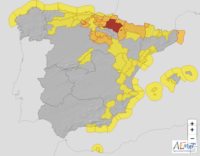
This day a red warning (extreme risk level) had been activated in the centre of Navarre for snow accumulations of 25 centimetres in 24 hours. At the same time, in the Navarre Pyrenees, the warning was orange for accumulations of 35cms.
General warning levels and thresholds.
Storms
- Yellow level: Widespread thunderstorms with the possibility of the development of organised structures. Locally heavy rain and/or locally strong winds and/or hail of less than 2 cm. Given the nature of these phenomena, there is the possibility of occasional storms of greater intensity.
- Orange level: Very organised and widespread thunderstorms. Locally very heavy rain and/or locally very strong winds and/or hail larger than 2 cm are possible. Tornadoes are also possible.
- Red level: Highly organised storms. The probability of locally heavy rain and/or locally very strong winds and/or hail larger than 2 cm is very high. Tornadoes are likely.
Avalanches
- Yellow level: Index 4 (strong) with departure level below 2100 metres or 5 (very strong), with departure level above 2100 metres.
- Orange level: Index 5 (very strong) with exit level below 2100 metres.
- Red level: Exceptional situation of generalised risk level orange affecting a wide area.
Thaws (Castile and Leon, Aragon, Navarre and La Rioja).
- Yellow level: when precipitation conditions and rising temperatures, with previous snow accumulation in mountain ranges, so require, at the forecaster's discretion.
- Orange level: when precipitation conditions and rising temperatures, with previous snow accumulation in mountain ranges, so require, at the forecaster's discretion.
- Red level: when precipitation conditions and rising temperatures, with previous snow accumulation in mountain ranges, so require, at the forecaster's discretion.
Thresholds and warning levels by zones.
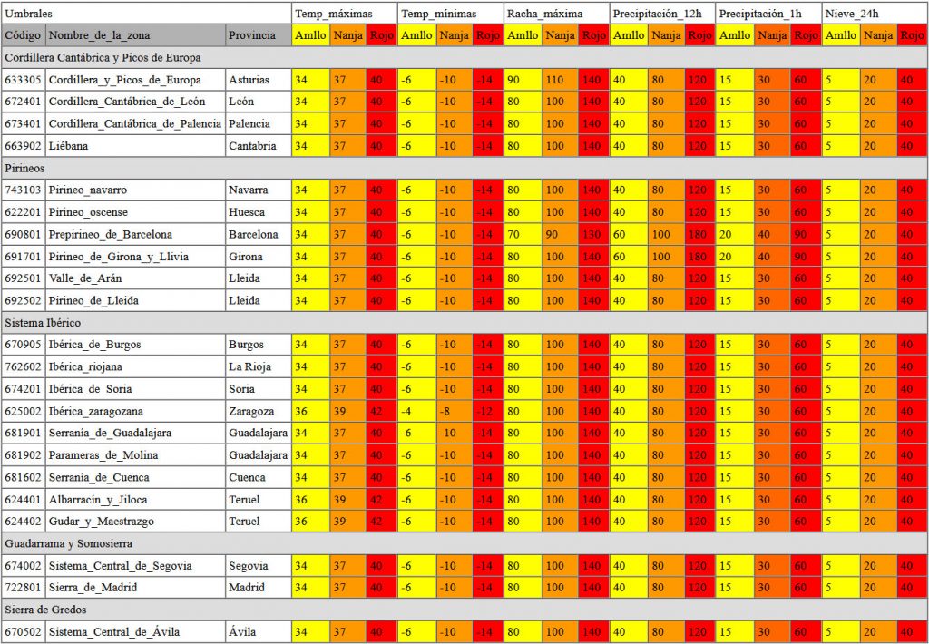
As we have already mentioned, Spain is currently divided into 183 zones. The thresholds corresponding to each of them can be consulted in the Meteoalert Plan, in the document: thresholds and warning levels.
Taking as a reference the 9 mountain areas proposed by the AEMET from a weather forecasting point of view (Picos de Europa, Navarre Pyrenees, Aragonese Pyrenees, Catalan Pyrenees, Riojan Iberian, Aragonese Iberian, Guadarrama and Somosierra, Sierra de Gredos and Sierra Nevada), the following table shows the thresholds and warning levels of the 22 zones that make up these 9 areas.

Avalanche Danger Bulletin.
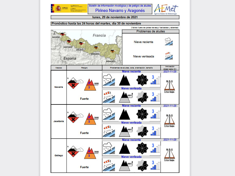
Although it is not exactly a part of the weather forecast, the AEMET is in charge of producing the Avalanche Hazard Bulletin (AHB)The newsletter is an essential tool for planning activities and risk management when going to the snowy mountains. To consult the latest bulletin, just click on the link above and download the pdf file of the area of interest.
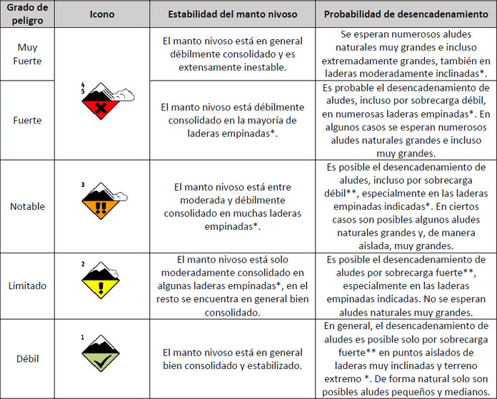
The avalanche danger is assessed using a five-level scale, which is commonly used in all European countries.
- Green = Level 1 (Weak)
- Yellow = Level 2 (Limited)
- Orange = Level 3 (Merit)
- Red = Level 4 (Strong)
- Red/Black = Level 5 (Very strong)
Final recommendations:
The Meteoalert Plan includes some generic recommendations for the population by warning level. In the case of mountain sports there is no written rule and depending on the level of warning for a given phenomenon, the degree of exposure of the activity, the level of the group and other conditioning factors, the mountaineer, canyoner, speleologist... will have to assess the degree of danger that can be assumed.
In general, based on the recommendations of the Meteoalert Plan, we can expect the following:
- Green: "The weather is not expected to cause significant impacts, although they may be minor or local in nature."
- Yellow: "Stay tuned. Keep up to date with the latest weather forecast. Some outdoor activities may be altered". This is the case for activities such as canyoning or caving when there is a yellow warning for storms. The recommendation is to leave them for another day if there is no one in the group trained to assess the situation (have a detailed report of the area, areas of influence, precipitation thresholds, etc.). This may also be the case for activities such as climbing in high mountain terrain or ridge walks, when there is a warning for strong winds, snowfall, storms...
- Orange: "Be prepared. Take precautions and stay informed of the latest weather forecast. Normal and outdoor activities may be disrupted". It will depend on the weather phenomenon for which the warning has been issued (rain, snowfall, wind, storms, temperatures, avalanches, thaws) and the activity we are going to carry out. In any case, if the warning is orange for rain or storms, water activities such as canyoning will be ruled out. In the case of mountaineering, if the warning is for snow, rain, wind, avalanches... it is best to opt for a plan B, more appropriate to the circumstances.
- Red: "Take preventive measures and act according to the instructions of the authorities. Keep informed of the latest weather forecast. Normal activities may be severely disrupted. Do not travel unless strictly necessary". As in the previous case, depending on the phenomenon for which the warning has been issued and the activity to be carried out, we will choose to suspend it or make a plan B if it does not involve any risk.
And when there is danger of avalanches, is it safe to carry out mountain activities?
From Mountain Segura A tool has been developed, the "Route Planner", which allows the degree of danger assumed by the mountaineer in the proposed activity on a specific day to be defined. Thus, the mountaineer can redirect his activity when the degree of danger is excessive or exceeds the experience and training of the group.
Briefly, the mountaineer must have the weather information, the latest BPA, the ATES map and the route planner chart.
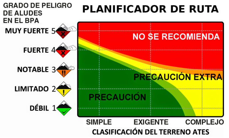
* The ATES map is a cartography that classifies the terrain according to its degree of exposure to avalanches. In Aragon, the Aneto, Posets and Infiernos massifs are available, and in Catalonia, all the massifs at risk of avalanches.
Fastpacking is not about going faster. It's about going lighter.
If you come from classic trekking, this is the next step: learning to move with less weight,
more fluid and enjoying every kilometre more.
Join the Outsiders Newsletter and start discovering what lightness feels like.
