How to create and plan mountain routes from home: The apps I use
Pyrenees and mountains 📩
Here 🔥Today I am going to share with you how I plan my mountain routes and what apps I use for this purpose. I hope you find this information useful for your next adventures.
To plan my routes, I use several applications that allow me to create the track, know the area where I will pass through, find good places to spend the night, such as shelters or camping areas, and know where there are water points. And to monitor the weather: rain, snow, wind and even webcams.


Planning the mountain route
We start with planning the route. This encompasses:
- Knowing where to pass, where there are roads and what kind of roads
- Where to spend the night (good areas)
- Finding shelters
- Water points
For this I use the following applications:
- Mapy.cz (the one I use the most, for almost everything)
- Google Maps (see satellite view, search area, shelters)
- Google search engine (locate shelters)
- Google Earth (to see the terrain a little better in 3D, and to get a better idea of what I might find).
- YouTube (to look for something specific, an area, a stretch, and especially in more known areas).
To create the route itself, the application I use the most is Mapy.cz.
Mapy.cz: A very complete application to create your routes
Mapy.cz is a very complete tool, with many customisable options to adapt it to your needs. One of the functions I like the most is the possibility of downloading the maps of the area I'm going to visit so that I can consult them without coverage. However, it is important not to rely completely on the GPS of the mobile phone, as sometimes it can be not very accurate.
We have a lot of things here.
- One thing to keep in mind is that if we log in, we create a route and save it, if we log in on another device we have it there too.
- Maps of the area you are interested in can be found at the following locations download to be able to consult them without coverage.
However, you have to be careful and don't rely 100% on the GPS on your mobile phone. Generally it works well but there have been situations where it has played a dirty trick on me, it went crazy and it was not very correct where it said I was.
- There are a few things that can be "customised" or added in the settings depending on individual taste. For example: "Very steep marks in pink", these marks indicate where there is a steep slope, but more than a slope, a drop.
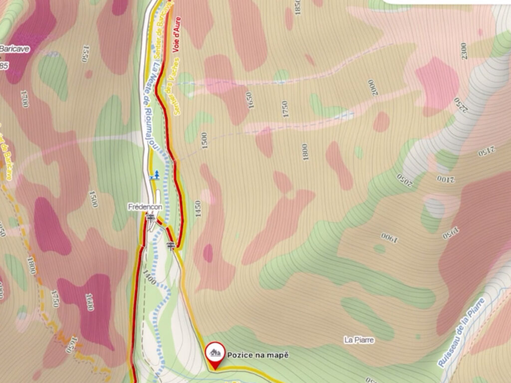
A bit of general interpretation:
- Contour linesThe closer together, the steeper the slope.
- Roads in red, are GR (major routes)The most frequented and most typical.
- Roads in yellow, are PR (small routes)are still busy.
- Trails (grey dashed line)The trails, which are usually not so busy, can sometimes be a bit unkempt or "wild".
- The following are also indicated summits and points of interest or referenceAnd if we zoom in, we can see water points, rivers, refuges...
We can also search for it in the search engine (search for shelters), but sometimes it fails or may not show something.
Navigation with Mapy.cz: How to create your track and export it
As for navigation, we can mark a specific point and the application will create a recommended track for us. It also has a quick mode and a tourist mode to adapt to our needs. Once the track has been created, we can export it and transfer it to our GPS or watch to follow it on the route.
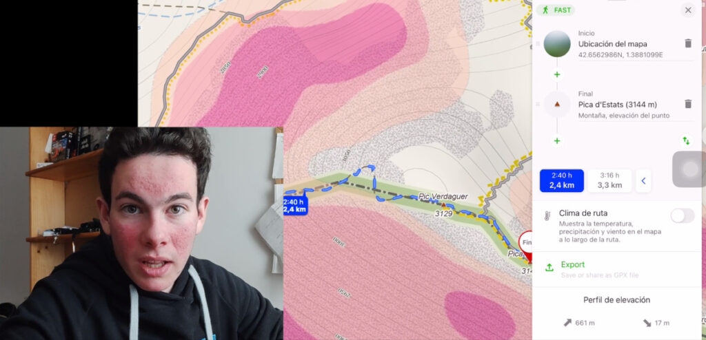
Let's go into detail. Step by step.
- We can mark a point we want or something concrete.
- We click "GO", and it creates the track where he recommends us to go.
- Fast modeTheoretically, it suggests the places where it will take you less time, but it can take you through more technical sections.
- Tourist modeMore typical roads, and perhaps not so fast.
- We will see that it indicates both the Km, m of positive and negative difference in altitude, and the estimated time it will take us.
- Export track. When we have created the track we can export it and transfer it to our gps or watch.
- And if we want to follow the track in the same application is very similar to Google Maps.
- Searching for shelters. On the subject of finding refuges, if you type refuges in the search engine you will find some, but I always end up looking for them in the Google search engine and Maps, mainly to look for reviews, to find out what state they are in, if they are well known, free or saved and if they are open, of course.
Weather: How to check the weather forecast with Windy
As for the weather, I use the Windy applicationwhich allows me to check the weather forecast in detail and in real time. You can also find more localised information on specialised websites.
Sometimes I consult a more local website, especially for avalanche danger if it is the case.
But in general, the one I use the most is Windy. We have a lot of things here too. In fact, I don't use it for everything it has.
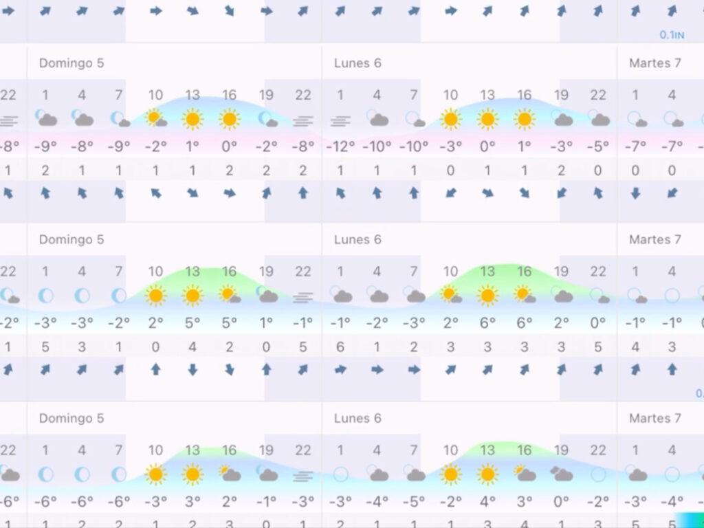
Let's go into detail. Step by step.
- Here we can select what we want to be shown (in the video you can see how I show you the menu) and more layers.
- If we extend it much further we also have a map very similar to mapy'sbut without being able to create routes or anything else.
- If we look for a point of interest we want and press , select "forecast for this location"
- And once here we have the "basic"and other more comprehensive ones.
- We can see from clouds, precipitation, wind...
- The different agencies. And if we click on "compare"We can have the forecasts of all the agencies for the same location. This is very interesting because sometimes an agency can give a forecast that is not very accurate, and this way we have a more general overview.
- The issue of webcamsIt's something I really like to see how a certain area is at the moment. I have it activated and where there is a webcam I can see it, generally in a refuge, ski slopes or also on roads, very useful to know what state they are in and what we can find.
In a nutshell
In short, planning your mountain routes is essential to ensure your safety and enjoy the experience to the fullest. With the apps I have recommended, you will be able to create routes, know the terrain and be prepared for weather conditions.
This is how I plan my routes, it must be said that it is also a matter of practice and experience, the more you do, the easier it will be to prepare and also to correct mistakes that we make at the beginning.
Fastpacking is not about going faster. It's about going lighter.
If you come from classic trekking, this is the next step: learning to move with less weight,
more fluid and enjoying every kilometre more.
Join the Outsiders Newsletter and start discovering what lightness feels like.