The best hiking trails in Andalusia
![North face of Mulhacén / Photo: Carlos Serra [CC-BY-SA-3.0].](https://travesiapirenaica.b-cdn.net/wp-content/uploads/2018/11/Cara-norte-del-Mulhacén-desde-la-pista-de-Sierra-Nevada_by-Carlos-Serra_CC-BY-SA-3.0_800x600.jpg)
Pyrenees and mountains 📩
Here 🔥Walking in six of southern Spain's most beautiful Natural Parks, all of which share a part of the magnificent Betic mountain range. Includes the author's recommendations for the best places to stay in or around southern Spain's most beautiful mountain villages, many of which date back to Moorish times.
The Natural Parks of Andalusia generally enjoy a mild climate in winter, spring and autumn, so walking is possible at any time from mid-September to mid-June. Even in mid-summer you can comfortably hike in the higher Natural Parks of Cazorla and La Alpujarra.
READ ALSO: The best trekking routes in Spain".
Aracena
The routes
- Eastern route
- Western route
- Route East of Alájar
- Route West of Alájar
- Almonaster Route
- Galaroza Route
Costa de la Luz
Natural Park of La Breña and the Marismas
- Walk 2 Las Marismas de Barbate circuit
- Walk 3 Vejer de la Frontera southern circuit
- Walk 4 Los Caños de Meca circuit
- Walk 5 Cape Trafalgar to Conil via the Torre de Castilnovo
Natural Park of Los Alcornocales and of the Strait
- Valdevaqueros by Punta Paloma
- River Guadalmesí
- The Pelayo by the Tower of Guadalmesí
- Río de la Miel
- Gibraltar through the Mediterranean Steps
- Jimena de la Frontera southern route
- Jimena de la Frontera northern route
- La Sauceda to Pico del Aljibe and back
- Casares Route
- Gaucín Route
- Benarrabá Route
Coast of Almeria
The picturesque coastline of Andalusia is a walker's walker's dream. Nestled between the mountains and the sea, walkers are hikers are rewarded with dazzling mountain views and breathtaking seascapes. mountains and breathtaking seascapes. The sense of history history embedded in these ancient coastal paths - which date back to ancient times - is the sense of history embedded in these ancient coastal paths - dating back to bygone eras - is an added delight that enriches further enriches the walk.
The coastal strip of Andalusia enjoys a temperate climate in winter, spring and autumn. mild climate in winter, spring and autumn, while even in mid-summer walks can be even in mid-summer walks can be pleasant thanks to the cooling influence of the Mediterranean Sea. thanks to the cooling influence of the Mediterranean Sea.
Níjar-Cabo de Gata Natural Park
- San José by Monsul and Los Genoveses
- Presillas Bajas to Majada Redonda and back
- Los Escullos by San José
- Rodalquilar by Cortijo del Fraile
- Las Negras by El Playazo
- Agua Amarga to Las Negras
Sierra Nevada
Sierra Nevada, the highest mountain range in mainland Spain and Western Europe outside the Alps. Easily accessible from Granada and Malaga, it is a world of snow-capped peaks and deep valleys, far removed from the crowded beaches of the Costa del Sol just two hours away. Routes extend throughout the national park, with attractive villages and towns such as Trevélez, Lanjarón, Hoya de la Mora and Cumbres Verdes as possible bases for a walking holiday. In the Sierra Nevada we can visit the highest point in mainland Spain, the Mulhacén, or walk through villages such as Trevélez, Lanjarón and Capileira. It includes traverses along the main ridge, high mountain climbs and the challenge of the "Three Peaks" of the sierra.
When to go?
The routes are mainly undertaken in summer; in winter we must bear in mind that, depending on the altitude, we may encounter wintry conditions. In the summer months, the temperature can be a problem, and we have to take into account the location of the springs.
Reference cities & Services
Trevélez, Capileira, Lanjarón, Nigüelas, Dílar, Cumbres Verdes, Granada, Sierra Nevada, Güéjar Sierra, Jérez de Marsquesado
To be seen
Mulhacen, the highest mountain on the Iberian Peninsula; Los Tres Picos - the three highest peaks of the Sierra Nevada; Los Tres Miles Integral - a multi-day trek covering all the main 3000m peaks; high level summer ascents.
The routes
The routes have been carefully chosen to showcase the dramatic landscape of the Sierra Nevada, with rocky barren peaks, lush green valleys, arid wastelands and tranquil lakes. From quieter hikes in the Cumbres Verde area to ascents of the highest peak in mainland Spain, Mulhacen,
Trevélez
- Ascent to the Alcazaba by the Cañada de Siete Lagunas (Seven Lagoons Gully)
- Ascent to Mulhacén through the Cañada de Siete Lagunas
- Ronda of the Juntillas and Trevélez river valleys
Capileira
- Circular Poqueira ravine
- Ascent to Mulhacén from Hoya del Portillo
Poqueira Refuge
- Ascent of the Mulhacén from the Poqueira Refuge
- The peaks of the Caldera
- Around Mulhacén through the Vasar and Siete Lagoons
- The Pulpits
Western Alpujarras
- Peak of Tajo de los Machos and Cerrillo Redondo
- Ascent of the Cerro del Caballo from the South
- Ascent to the Cerro del Caballo by the Tres Mojones
Dílar Valley
- Padul Silleta
- Integral de los Alayos
Cumbres Verdes
- Boca de la Pesca
- Trevenque by the Cuerda del Trevenque
- Trevenque and Dílar Valley Circuit
- Cerro Huenes Group
- Tesoro Peak and Cocon Hill
- Direct Trevenque
Ski resort - Hoya de la Mora
- Veleta, Tajos de la Virgen and Lagunillas
- Veredón Superior and Cerro de los Machos
- Lower Veredon, Veta Grande, north flanks and lakes
- Across the mountains to Lanjarón via Refugio Elorrieta
Vereda de la Estrella/Valle del Genil
- Vereda de la Estrella, Refugio Cucaracha and Cueva Secreta (Secret Cave)
- Cortijos del Hornillo circular
- Ascent of Mulhacén via Cueva Secreta (Secret Cave)
- Tour of the northern peaks via Peña Partida
Jérez del Marquesado and Postero Refuge High
- Ascent to the Picón de Jérez and return to the Alhorí valley.
Puerto de la Ragua
- The Eastern Peaks
Traverses and long distance
While some are day or half-day hikes, others take advantage of the region's network of mountain refuges or offer the opportunity for free camping. Also included are three longer traverses: 'Los Tres Picos' (Veleta, Mulhacén and Alcazaba), 'Los Tres Millas' Integral (a multi-day hike covering all the main 3000m peaks in the range) and an overview of the 302km Sulayr GR240.
- The 'Three Thousands' Integral 3000m peaks
- The Three Peaks - Veleta, Mulhacén and Alcazaba
- The Sulayr GR240
High Mountain ascents and climbs (grade 2 and 3 pitches)
- Alcazaba Spur
- Puntal de la Caldera Crossing
- Caldera Spur
- Arista de las Campanitas
- Tozal del Cartujo North Range
Mountains of Nerja: Sierras Tejeda, Almijara and Alhama in the Axarquia region
The small town of Nerja, on the Costa del Sol, is nestled beneath a range of mighty mountains. These are the Sierras de Tejeda, Almijara and Alhama. Together they comprise 50 mountains of over 1,000 m, the highest, La Maroma, over 2,000 m, and offer hikers exceptional routes.
Explore the white mountain villages of Frigiliana, Competa, Canillas de Albaida, Canilas de Aceituno and Salares, all within easy reach of Nerja.
Practical guide
When to go?
The best time of year for hiking in these mountains is from late April to late May. Late summer and early autumn are also cooler, but the ground is 'burnt' and dry. Between November and April there is more chance of rain, but it is still acceptable for hiking.
Cities & Services
Any of the routes in this guide can be done as a day trip from Nerja, making this charming coastal town a good place to rest and use as a base camp. Nerja and Vélez-Málaga
To be seen
outstanding natural beauty; 50 Munro Mountains in an area the size of the Isle of Skye; severe geological features on mountains over 2000m; tranquil and remote valleys where nature is just minutes away. away.
The routes
Routes in the Sierras of Tejeda, Almijara and Alhama in the region of Axarquia. The walks are accessible from the towns of Nerja and Velez-Malaga on the Costa del Sol. The routes range from easy walks to strenuous ascents. The mountains are largely limestone, with some peaks reaching over 2000m.
Nerja and surroundings
- Frigiliana to the Nerja Cave
- The Fort
- Pinto Cross
- The Chillar River Gorges
- El Cielo Circuit
- The Almendron route
The Competa
- The Light Factory
- Lucero
- Cerro de la Chapa
- The oak forest of Salares
- Cómpeta to Los Pradillos
La Maroma
- La Maroma from Canillas de Aceituno
- La Maroma from Alcaucín
- La Maroma from Sedella
- La Maroma from Alcaicería
The Rio Verde Valley
- Navachica
- The Petrified Waterfall
- Lopera
Routes from the north
- Ventas de Zafarraya
- Malascamas
- The Gorge of Alhama de Granada
- La Resinera
- Jayena to Haza de la Encina
Swan
- Swan from Acebuchal
Sierras de Ronda and Grazalema: Natural Parks of Grazalema and La Sierra de las Nieves, Genal and Guadiaro valleys.
The well-located town of Ronda can be a great starting point for a hiking holiday in the Andalusian mountains, as can any of the picturesque white villages nestling among the surrounding hills.
While Ronda is famous for its impressive gorge and Moorish architecture, the surrounding countryside offers magnificent scenery at every turn. With spectacular limestone peaks, fertile river valleys and ancient almond and olive groves, the natural beauty of Ronda and Grazalema is sure to impress.
Practical guide
When to go?
Andalusia can be visited with the intention of hiking practically all year round, thanks to its relatively mild winters: the best time is from mid-September to mid-June. During the summer months temperatures can be too high for easy walking, while occasional snowfalls in winter can make the higher walks more challenging.
Cities & Services
Ronda, Grazalema, Zahara de la Sierra, El Burgo, Júzcar, Benarrabá, Genalguacíl, Gaucín, Montejaque, Benaoján, Jimera de Líbar, Igualeja, Alpandeire, Cartajima, Benamahoma
To be seen
Ronda, with its spectacular gorge; the UNESCO biosphere reserves of Sierra de Grazalema and Sierra de las Nieves; the spectacular limestone peaks; the fertile river valleys; the almond blossom in early spring.
The routes
This guide presents mainly circular walks in the comarca of Ronda, covering the city and its surroundings, the Sierra de Grazalema and Sierra de las Nieves Natural Parks (both UNESCO Biosphere Reserves), and the Genal and Guadiaro Valleys. Ranging in length from 3.5 to 16.5 km, many hikes are easy to moderate and almost all can be done from mid-September to mid-June, thanks to the area's relatively mild winters.
Ronda and the Sierra de las Nieves
- Caucón Pass via El Tajo de la Caina
- The Rock of Lovers
- Los Sauces by La Cueva del Agua
- El Burgo through the Puerto de la Mujer
- La Torrecilla by the Puerto de los Pilones pass
- Ronda Ravine
- Ronda to the Tajo del Abanico and the hermitage of the Virgen de la Cabeza
- Historical tour of the old town of Ronda
The Genal and Guadiaro Valleys
- Cartajima east circuit via Parauta and Igualeja
- Cartajima south circuit via Pujerra and Júzcar
- Route through Alpandeire
- Benaoján Station to Jimera de Líbar Station
- Station from Benaoján to La Cueva de la Pileta
- Jimera Station
- Cortes de la Frontera by Los Pinos
- Cortes de la Frontera southern circuit
- Route from Benarrabá to Genalguacíl
- Gaucín
- Montejaque Route
The Sierra de Grazalema
- North Grazalema Circuit
- Grazalema South Circuit
- Grazalema to Benaocáz
- The Pinsapar de Grazalema
- Puerto de las Palomas by the Coros peak
- Circuit Villaluenga by Navazo Alto and Bajo
- Ascent to the Torreón
- El Gastor via Lagarín and Las Grajas
- El Gastor by Huerta Lagarin
- The Green Gorge
- Algodonales by El Canalizo
- Zahara de la Sierra
- Benamahoma Circuit
Cazorla
The routes
- South Cazorla Route
- Cazorla southwest circuit
- Cazorla southeast circuit
- La Iruela Circuit
- Walk through the Borosa River gorge
- Circuit Puente de Las Herrerias
The best trekking in Andalusia
GR 7 E-4 Andalusian Footpath: from Tarifa to Puebla de Don Fadrique
Hiking guide to the GR7 in Andalusia, from Tarifa to Puebla de don Fadrique. Both variants included; north through Cordoba, south through Granada. Over 700km long, the walk takes over a month and explores varied landscapes, including the Sierra Nevada. Practical details of accommodation are included to help with planning.
The fully signposted route passes through seven stunning natural parks and the Sierra Nevada National Park, home to the highest peak in mainland Spain, the Mulhacen. All the information needed to plan a hike is included. The stage maps use official IGN maps. Detailed route descriptions are provided for about 60 days of walking, with options to create shorter sections and days. The GR7 avoids tarmac roads wherever possible, instead taking old trade routes, bridle paths and even goat tracks, there are only a few steep uphill sections, so this route is suitable for walkers of reasonable fitness and navigational ability.
With its white sandy beaches, pine and oak forests, desert-like plateaus, snow-capped peaks, traditional villages, lush river valleys and olive groves, the GR7 in Andalusia takes you on a journey through the most geographically diverse region of the Iberian Peninsula. Famous among holidaymakers for its coastline, the GR7 offers the chance to see another side of Andalucía. You'll explore little-visited hidden gems, enjoy natural parks and visit quiet, unspoilt villages.
Detailed route description for about 60 days of walking, with options to create shorter sections and days.
Information on all the villages en route, including accommodation, so you can plan your own route.
When to go?
Spring (March-June) and autumn (September-October) are recommended. Avoid July and August for heat (up to 40°C) and winter for lack of facilities.
Cities & Services
Starting point: Tarifa; finishing point Puebla de Don Fadrique
Difficulty
Signposted route. North variant = 711.5 km with almost 16,500 m ascent (34-41 days). Southern variant = 719.8 km with 16,860 m ascent (34-42 days). Facilities en route most days
To be seen
Nature parks, historic towns, whitewashed villages of the Alpujarras, cave houses, Ronda, view from Antequera castle, Priego de Córdoba, castles in Jaén, museum in Orce
The route
Complete guide to walking the GR7 through Andalusia in southern Spain. Both variants are included, the northern one visiting Cordoba and the southern one passing through Granada and the Sierra Nevada. This wonderfully varied route starts in the far south of Spain, on the coast at Tarifa, and winds through the provinces of Cadiz and Malaga before splitting off. The northern fork is 718km, 34 to 41 days in total, while the southern fork is 735km, 35 to 42 days. Both routes end in Puebla de don Fadrique. Part of the E4 route.
1 Cadiz and Malaga
Cadiz
- Stage 1 Tarifa - Los Barrios
- Stage 2 Los Barrios - Castellar Castle
- Stage 3 Castle of Castellar - Jimena de la Frontera
- Stage 4 Jimena de la Frontera - Ubrique
- Stage 5 Ubrique - Montejaque
Malaga
- Stage 6 Montejaque - Arriate
- Stage 7 Arriate - Ardales
- Stage 8 Ardales - El Chorro
- Stage 9 El Chorro - Valle de Abdalajís
- Stage 10 Valle de Abdalajís - Antequera
- Stage 11 Antequera - Villanueva de Cauche
2 North Fork - Málaga, Córdoba and Jaén
Malaga
- Stage 12A Villanueva de Cauche - Villanueva del Trabuco
- Stage 13A Villanueva del Trabuco - Villanueva de Tapia
- Stage 14A Villanueva de Tapia - Villanueva de Algaidas
- Stage 15A Villanueva de Algaidas - Cuevas de San Marcos
- Stage 16A Cuevas de San Marcos - Rute
Cordoba
- Stage 17A Rute - Priego de Córdoba
- Stage 18A Priego de Córdoba - Almendinilla
- Stage 19A Almedinilla - Alcalá la Real
Jaén
- Stage 20A Alcalá la Real - Frailes
- Stage 21A Frailes - Carchelejo
- Stage 22A Carchelejo - Cambil
- Stage 23A Cambil - Torres
- Stage 24A Torres - Bedmar
- Stage 25A Bedmar - Jódar
- Stage 26A Jódar - Quesada
- Stage 27A Quesada - Cazorla
- Stage 28A Cazorla - Vadillo de Castril
- Stage 29A Vadillo de Castril - Coto-Ríos
- Stage 30A Coto-Ríos - Pontones
- Stage 31A Pontones - Santiago de la Espada
- Stage 32A Santiago de la Espada - Puebla de Don Fadrique
3 South Fork - Malaga and Granada
Malaga
- Stage 12B Villanueva de Cauche - Riogordo
- Stage 13B Riogordo - Ventas de Zafarraya
Granada (and Almeria)
- Stage 14B Ventas de Zafarraya - Alhama de Granada
- Stage 15B Alhama de Granada - Arenas del Rey
- Stage 16B Arenas del Rey - Jayena
- Stage 17B Jayena - Albuñuelas
- Stage 18B Albuñuelas - Nigüelas
- Stage 19B Nigüelas - Lanjarón
- Stage 20B Lanjarón - Soportújar
- Stage 21B Soportújar - Pitres
- Stage 22B Pitres - Trevélez
- Stage 23B Trevélez - Cádiar
- Stage 24B Cádiar - Yegen
- Stage 25B Yegen - Laroles
- Stage 26B Laroles - Puerto de la Ragua
- Stage 27B Puerto de la Ragua - La Calahorra
- Stage 28B La Calahorra - Narváez
- Stage 29B Narváez - Zújar
- Stage 30B Zújar - Benamaurel
- Stage 31B Benamaurel - Cúllar
- Stage 32B Cúllar - Orce
- Stage 33B Orce - Huéscar
- Stage 34B Huéscar - Puebla de Don Fadrique
Other routes:
- Caminito del Rey (Malaga)
- The Coastal Path - GR92 E12
- From Algeciras to Tarifa, Colada de la Costa (Cádiz)
- Sierra de Aracena and Picos de Aroche Trails (Huelva)
- Path of the Alpujarra (Almeria, Granada)
- The hanging bridges of Los Cahorros (Granada)
- River Borosa, Cazorla (Jaén)
- Bailon River Path (Cordoba)
- El Torcal de Antequera (Málaga)
- Veleta Peak, Sierra Nevada (Granada)
Discover the best hiking routes in Andalusia.
What are some recommended hiking routes in Andalusia? Let's take a look at some of them.
1. Route of the River Chillar, Nerja Malaga.
One of the routes to practice hiking in Andalusia The most interesting is the Rio Chillar route near Nerja in Malaga, where sport and contact with nature come together for a simply spectacular walk. The route goes all the way to the well known Vado de los Patos, and even further on to the famous dam or Cortijo Imán. Usually most walkers go as far as the Vado, as the section from there to the Cortijo is steeper and more difficult. In general, the route is of medium difficulty, where the first section of the route covers a distance of 8 km one way. The time required to complete the round trip is approximately 6 to 7 hours depending on your speed and the number of stops you make. The scenery on this route is breathtaking, and part of the way along the river, so it is advisable to wear water shoes. One of the main attractions of the Chillar River Route is at one of the river's ascents, where there is a large water reservoir. Here the more daring hikers make a stop to bathe in this beautiful natural pool covered with rocks where you can cool off after your exercise.
2. Caminito de Rey Route, Malaga.
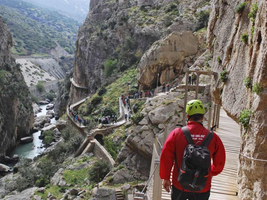
The Caminito del Rey is possibly the best known hiking route in Andalusia on the list. Just the pictures that flood the internet, make anyone who wants to enjoy nature and live an experience full of emotion, want to be there. Indeed, that reality is seen year after year, as thousands of locals and tourists from all over Europe take this route that takes place over huge wooden walkways attached to the rocks, generating an indescribable feeling of vertigo as you walk along the edge of the cliff. The route rises above the Guadalhorce River covering a distance of 8 kilometres. Other recommended hiking routes in Malaga are: Ruta de la Concha del Juanar, Pico de los Reales, Río Verde Sierra de las Nieves and Ruta SL-A 169 Fuente del Porejón.
3. Route from Conil to Calas de Roche in Cádiz.
At a moderate pace, the route can be done in about 4 hours round trip. The route is about 12 km long, and can be done along the beach itself, although it is more advisable to do it from the top, from where you can see the best panoramic view. The backdrop is unbeatable, as you will have the waters of Conil beach, breathing fresh air and enjoying the grandeur of the sea. As the route progresses you will see that the views get even better, making this one of the best hiking routes in Andalusia. The last kilometre of the route ends when you reach the cove of the oil, and you will see the famous sandbank near the port area, which is very popular with tourists. On the other side you can see the Roche lighthouse. Undoubtedly, this is one of the most famous routes in Cadiz, but it is not the only one as this province has several very beautiful and interesting hiking routes such as: Ruta Punta del Boqueron, the signposted trail Torro del Tajo (La Breña Natural Park), the signposted trail Las Quebradas (La Breña Natural Park), the Arrollo Mongragon route or the trail Fuente del Porrejon.
4. Route of Aracena in Huelva.
In Huelva, specifically in the Huelva municipality of Aracena, you will find numerous trails of varying lengths and with easy to moderate difficulty. You will also find several hiking trails that form part of the Sierra de Aracena y Picos de Aroche Natural Park. The Aracena route is rated medium to high difficulty and starts at Calle B in the Polígono Cantagallo. On this route you will see interesting curiosities such as the explanatory panels about the Iberian pig that is usually reared in the area. Along the route your eyes will be delighted by the incredible landscapes, where the colourful flowers of the countryside and imposing leafy trees stand out. What's more, if you decide to follow this route, you can also take the opportunity to visit the monuments that form part of the municipality's heritage. Some other hiking routes in Huelva that are worth doing are the following: La Turbera signposted path (Paraje Natural Marismas del Rio Piedras), Laguna Del Portil signposted path (Reserva Natural Laguna de El Portil), Nueva Umbría route (complex of the marshes of the river Piedras).
5. Route of the Arroyo de Guadalora Cordoba.
The Andalusian province of Cordoba also has some great hiking routes to do with friends, as a couple or with the family. One of the best known is the Ruta del Arroyo de Guadalora, in the Sierra de Hornachuelos. Hornachuelos is undoubtedly the largest natural park in Cordoba, located in the heart of the Sierra Morena. One of the main characteristics of this route are its numerous streams and reservoirs to enjoy a landscape bathed by water. The local fauna is another reason to take this route, as you will see birds such as the black vulture and the imperial eagle. It is definitely a wonderful natural area with little difficulty, so you can even do this route with your family. Cordoba also has other hiking routes, among which are: the Laguna de Zóñar Route, the Cerro Abuchite Route, the Río Yeguas Route and the Route from Almodóvar del Río to the Breña reservoir.
6. Los Cahorros Route, Granada.
The route of the Cahorros is located in Monachil, approximately 8 km from Granada and is one of the most popular routes to practice the hiking in Andalusia most exciting. Despite that, it is curious that it is one of the most unknown for tourists, but it is certainly perfect for the family, and even more so if you have a great adventurous spirit. Here you will find four suspension bridges, the longest of which has a length of 55 metres suspended 15 metres above the river. You will also see caves, natural pools and impressive waterfalls that form part of the entire route, making this one of the best scenic routes in Andalusia. Last but not least, if you are a climbing enthusiast, you will find huge rock walls where you can practice this sport. Granada also has other very interesting hiking routes such as the following: Ruta Cerrada del Río Castril, Ruta Barranco del Pleito, Ruta del Mamut and Ruta Río Dúrcal to mention just a few.
7. Rita Río Borosa at Cazorla in Jaén.
Jaén has fun and beautiful hiking routes that have something in common: the variety of wildlife and beautiful landscapes with waterfalls. Specifically in Cazorla, you have the Rio Borosa route which is characterised by its natural pools, huge waterfalls and diversity of fauna. It is one of the longest routes, as it is approximately 20 km long and can easily be done in about 6 hours as it is classified with an easy difficulty. The route follows a quiet path until you reach the fish farm and from there continue to the source of the river. The route is signposted, and runs for the most part around the river, enjoying the tranquillity, the fresh air and the beauty of the scenery. However, in Jaén you have the possibility of following other interesting routes such as: the route of the Organs of Despeñaperros, the path of the Chorreras in Valdepeñas, the route of the Sierra de Andújar Nature Reserve or the route of the Cimbarra Nature Reserve.
8. Route of the Arroyo de las Cañas, Seville.
The Arroyo de las Cañas Route is the least difficult on our list, making it ideal for families. It is a circular path which is very well signposted with a start and finish and is located in El Pedroso. The protagonist of this route is the famous Arroyo de las Cañas, as most of the route passes through its waters and the pleasant shadows of the holm oaks. Without a doubt, this route is ideal for enjoying the beautiful views of the Sierra Norte with your loved ones. The route is 12 kilometres long and of easy difficulty. Other recommended hiking routes in Seville are the following: Cote Castle Route (Montellano), La Zarcita Circular Route (Aznalcóllar), Mulva Ruins Route, Pico El Terril Route or the Cerro del Hierro Route.
Find your hiking route by province
- Almeria
- Cadiz
- Cordoba
- Grenada
- Huelva
- Jaén
- Malaga
- Seville
Fastpacking is not about going faster. It's about going lighter.
If you come from classic trekking, this is the next step: learning to move with less weight,
more fluid and enjoying every kilometre more.
Join the Outsiders Newsletter and start discovering what lightness feels like.