Learn how to use the map and compass
Pyrenees and mountains 📩
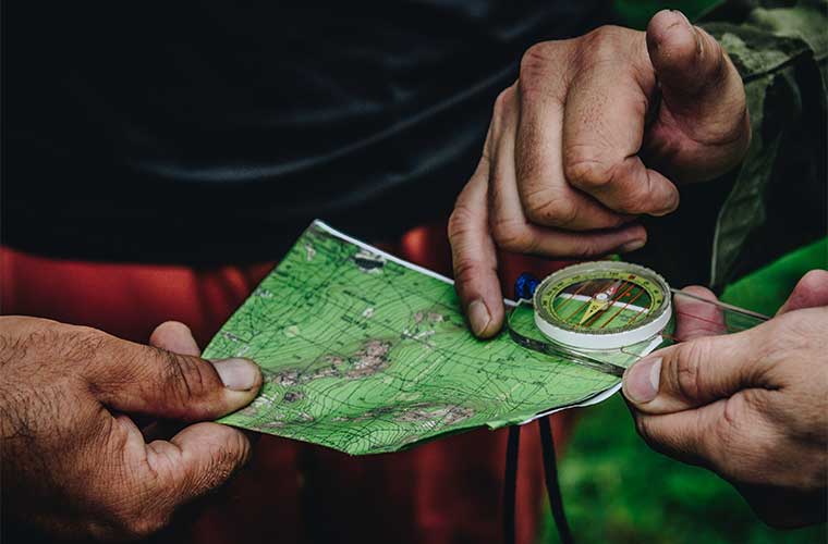
Here 🔥If you are one of those people who love outdoor sports, such as climbing, hiking or mountain biking, both the map and the compass are a pair of necessary tools for orientation and guidance. It is therefore necessary to learning to use the map and compassIt is vital for those wishing to start a mountain adventure.
Some terms used in these tools, such as latitude, longitude and degrees are of great importance and their meaning should be known. Latitude and longitude are geographical coordinates that are compared to two imaginary lines that cross the globe - that is, the earth - which are: the equator line and the degree meridian line or better known as the Greenwich meridian.
Basic concepts in the use of the map in the outdoors
All topographic maps have a specific coordinate system printed on them, which is intended to help locate them from any part of the planet. It is necessary to understand terms such as:
Latitudeis the angle that the vertical line of a point on the Earth's surface forms just as it meets the centre point of the plane of the Equator. It can vary from 0º degrees to 90º degrees. It is important to remember that points in the northern hemisphere of the planet have northern or positive latitude, and points in the southern hemisphere of the world have southern or negative latitude.
In order to have the correct position in a map reading, you must start from the lengthis discovered using the measuring fractions of the meridians, which are like imaginary lines running from one pole of the Earth's sphere to the other, from north to south, and from south to north.
In order to start using a map, you must find out exactly where you are, and then locate it on the map. and to be able to know where to go.
First and foremost will be orienting the map The map images will be matched to the surrounding landscape elements, and it should always be remembered that maps always show North at the top.
Basics in the use of the compass in the outdoor sector
Another tool, the compassThe most popular orientation tool. It will help us, among other things, to orienting the map -As mentioned above, the upper part of the map faces north.
There are different types of compasses, nowadays many types have been designed for different activities, such as for hiking, sports and leisure, etc.
Know the exact course and direction of a space or terrain. is simple. All you need to do is to stand first at a certain point, which can be called "A", and then look at the compass to which direction, called "B", you want to go. Without neglecting or losing sight of point "B", turn the compass until the magnetic point, which is generally red on all compasses, and the tail of the compass are exactly at the same north meridian mark. This is the way to read the bearing in degrees.
Fastpacking is not about going faster. It's about going lighter.
If you come from classic trekking, this is the next step: learning to move with less weight,
more fluid and enjoying every kilometre more.
Join the Outsiders Newsletter and start discovering what lightness feels like.