Hiking in the Ein Avdat National Park
Pyrenees and mountains 📩
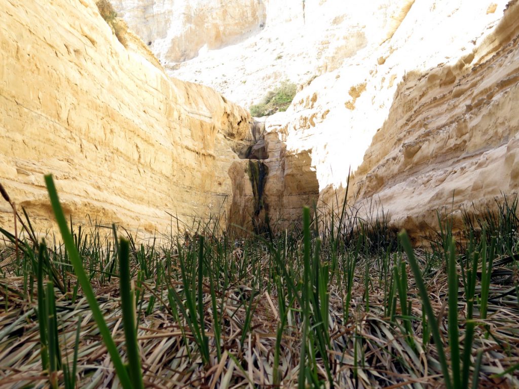
Here 🔥The desert landscape of the Negev is an impressive backdrop for hiking. Mitzpe Ramon, Timnah Park, Eilat, Ein Avdat or the nearby Judean Desert in Arad are home to an enormous variety of trails. In Ein Avdat the trails explore the geological past of the deep and impressive limestone canyon carved out by the Tsin stream.
YOU MAY BE INTERESTED IN: A roadtrip through the treasures of the Dead Sea and the Negev Desert".
Ein Avdat National Park
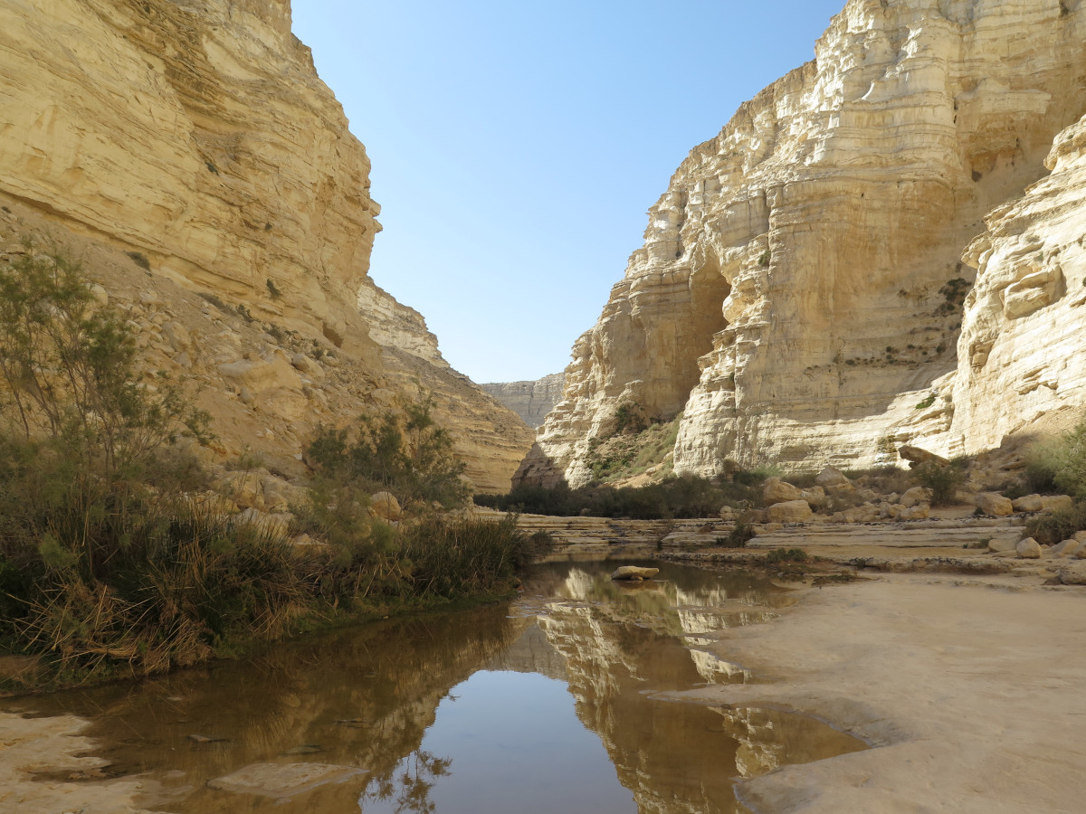
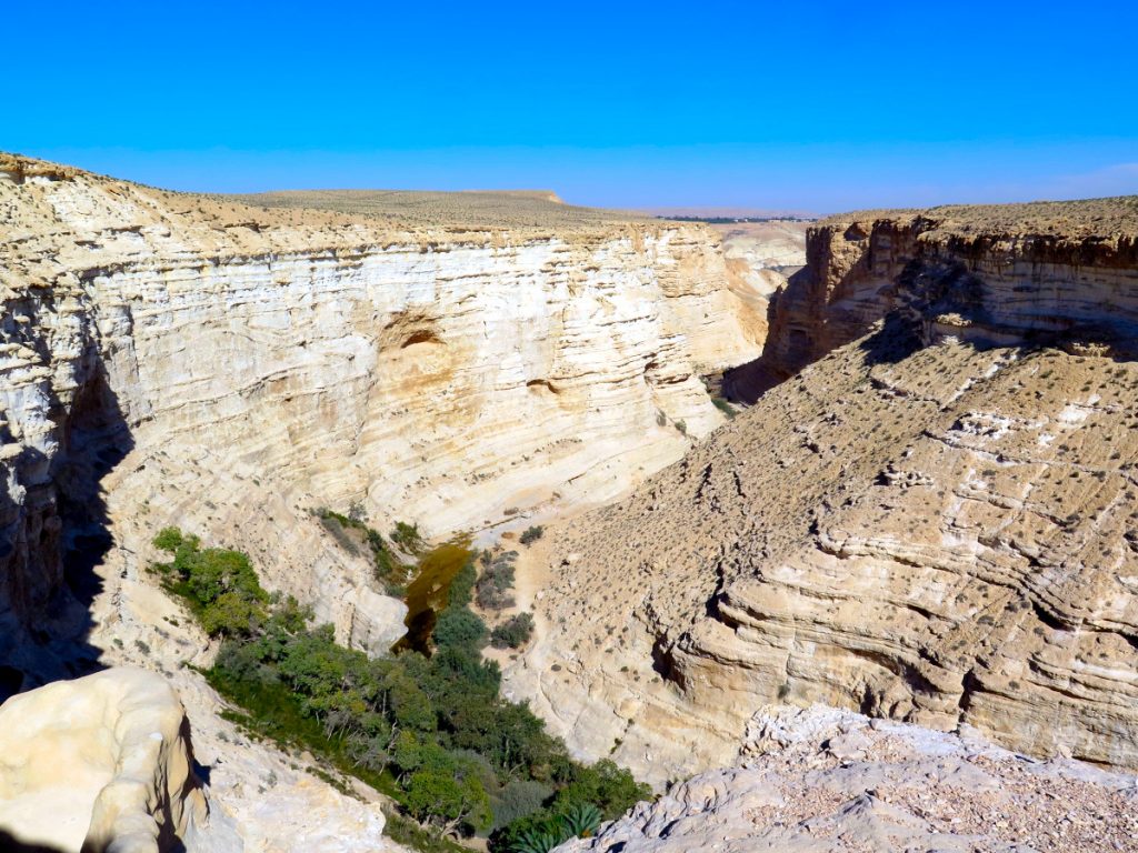
A long cliff rises to a height of 100 m or more between the upper Avdat and the Tsin valley. The broad bed of the Wadi Tsin, as well as the HaTsinim cliff, which stretches for some 20 km along the northern edges of the Avdat plateau, are the ideal playground for trekking enthusiasts.
En Avdat National Park is located in Wadi Tsin, on the northern edges of the Avdat plateau, 400-600 m above sea level. But in addition to an impressive desert landscape, a reservoir of wildlife (kingdom of ibex and vultures), the great cliffs of En Avdat are home to important archaeological remains of the settlements of Byzantine monks who found inner peace in the caves of the walls.
Its upper strata are made up of hard, white Eocene limestones, and the lower strata are soft (clays and marls). Erosion eventually resulted in deep canyons with high cliffs such as the En Avdat Canyon. The concentration of travertine and remains of some prehistoric sites in the area indicate that the canyon in its present form was created some 45,000 years ago. The greenery blends with the layers of white limestone, a landscape unique among the most beautiful in the Negev.
The Avdat National Park is home to the remains of a Nabataean settlement established as a way station for caravans travelling along the Incense Route. It is later because it was an important urban centre in Roman and Byzantine times (2nd to 7th centuries AD). From the remains of the city you can still see traces of cultivated areas, agricultural terraces, dams and cisterns from these periods.
You can walk to the Havarim cistern after turning east on road 40 at km 128, following the signs. This is a Nabataean cistern carved out of limestone rock on the north bank of Wadi Havarim, a tributary of Wadi Tsin. It is one of the most beautiful cisterns in the Negev and still fills with water when the wadi floods. The roof rests on a carved central pillar, which bears an ancient Nabataean symbol identified with Dushara, the chief Nabataean god.
Routes in the park
How to get there. Entrance.
On road 40 (Beersheba - Mitspe Ramon road). The lower entrance to En Avdat is near the Ben Gurion family tomb and Midreshet Sde Boker. The upper entrance is about 5 km to the south.
- North entrance (lower car park): Between km 130 and 131, turn east following the sign for Midreshet Sde Boker. Continue following the signs for about 4 km to the lower car park. This will be the start of the route which will be described below.
- The south entrance (upper car park): Between kilometres 123 and 124, turn east according to the sign. Approximately 1km along the road, you will reach the upper car park, from where you can walk to the viewpoint and the top of the upper Wadi Tsin waterfall. At this entrance you will find spectacular panoramic views across the entire canyon but there is no possibility to go down to the wadi.
The The best time to enjoy the routes in the Park is spring and autumn.. At the entrance of the Park you will be able to get the ticketsIf you are interested, the staff will provide you with a map and details of hiking options in the area.
Points of interest
- En Avdat waterfallA flowing waterfall, and at its feet, a crystal-clear pool in the watercourse.
- Euphrates poplarEuphrates poplar grove: a grove of Euphrates poplars, trees whose main distribution in Israel is along the Jordan River. The poplars are particularly beautiful with their yellow autumn tones in winter. They stand out in the aridity of the place.
- Caves of the monksIn Byzantine times, the caves were used by monks seeking the seclusion and tranquillity of the canyon.
- En Ma'arif viewpoint: Looking from the head of the canyon.
Route description
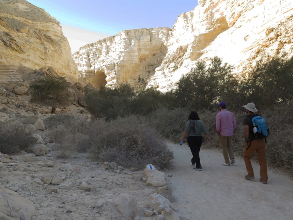
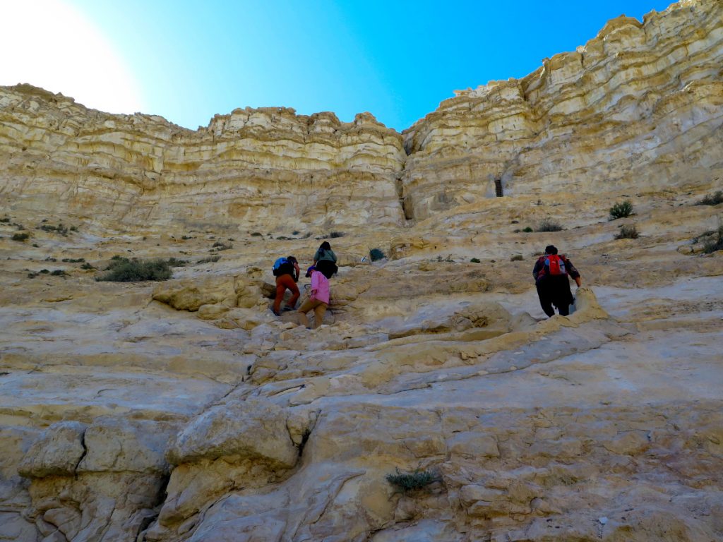
The path runs through the interior of the ravine. It starts at the north entrance and ends at the viewpoint at the south entrance. It is important to bear in mind that the final part of the route, with the ascent to the viewpoint (south entrance) is only one way. There are several flights of stairs on very steep terrain that can only be tackled by ascending (descending is forbidden). Bearing all this in mind, we have two options: to tackle the route in one direction and have a vehicle to pick us up at the viewpoint, or not to do the whole route (2 to 3 hours) (at least the final part we mentioned) and return to the north entrance from where we started the route (1 to 2 hours).
The entire route can take 2-3 hours. We will walk along Wadi Tsin from the lower car park through the lower pools and a grove of poplar trees to the upper car park (viewpoint). This trail includes a short, steep ascent of the canyon cliff to complete the route and reach the viewpoint. You will need a vehicle waiting at the other end, at the upper car park.
- North entrance. We start the hike from the lower car park, looking at the palm trees of En Mor. We cross the wadi bed and continue walking along the path on the other side of the wadi bed, on a natural stone terrace next to the lower pools of En Avdat, until we reach the waterfall of En Avdat (from this point it is possible to retrace our steps back to the lower car park if we are not going to tackle the final part of the hike).
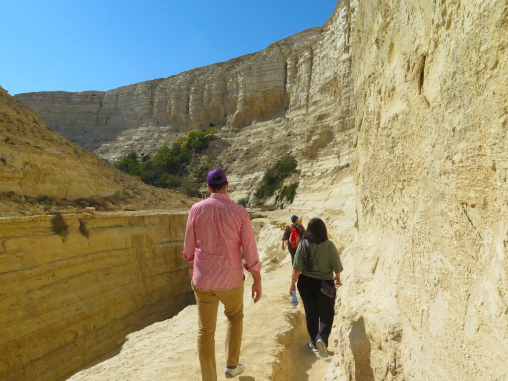
- En Avdat waterfall. We return to the intersection of the path and climb the narrow steps carved into the rock that will take us to the top of the waterfall. Excellent views from the top of the waterfall, some 25 m high, over the spectacular canyon, the pools and the canyon walls. We continue walking to the shade of some trees. On the canyon walls you can see the openings of the caves, which were used by monks in Byzantine times.
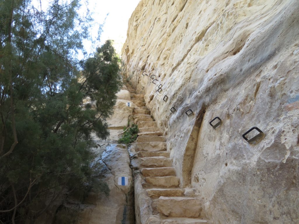

- Final ascent to the lookout point. Climb a short vertical segment using the steps and metal ladders specially installed for this purpose. The ascent is one way only, for safety. At the top of the slope, near the path, is a square structure, apparently a tower, used by monks in Byzantine times. From here the monks descended to the caves of their dwellings and to the small plots of land they cultivated near the stream bed. Continue along the cliff to the viewpoint (upper car park, south entrance), where a breathtaking view of the cliffs, the upper pools and the desert plateau awaits you.
It is a good idea to continue along the path south to the edge of the cliff above Wadi Tsin, to the top of the large waterfall, some 60m high, for another wonderful view of the wadi.
Safety instructions for hikers.
- Bring a map of the SPNI at a scale of 1:50,000 or a GPS with a map of the area.
- Wear a hat and carry water (and other provisions). Cover your head to avoid sunstroke and avoid walking in the unprotected hours of the day (from 12.00 to 15.00). Apply sunscreen. Spring water is not drinkable. Do not build a fire.
- In the rainy season in winter, we must be aware of weather forecasts in order to avoid being trapped by floods.
- To protect nature, do not bring dogs or other pets to the park.
- Do not swim in swimming pools.
- Be careful not to slip near the pools.
- Walk only on marked trails and be careful not to cause rock slides.
- Stay away from the cliff edge.
- Abseiling and climbing are prohibited.
- The stairs are one-way, for ascent only. So you will not be able to access the wadi from the south entrance (the viewpoint entrance).
- Visitors can only enter the park during opening hours.
- There are toilets near the upper and lower car parks.
- Do not damage flora, fauna or inanimate objects.
- Keep the park clean. Don't leave litter, take it with you.
- In general, for hiking in the Negev Desert, the Israel-Egypt border area should be avoided.