The 10 most beautiful mountains in the Pyrenees
Pyrenees and mountains 📩
Here 🔥The 10 most beautiful mountains in the Pyrenees, a difficult choice, because how do you measure the beauty of a mountain?
In any case, it is a pleasant task to think about what they might be. the 10 most beautiful mountains of the Pyrenees but unfairly, irremediably. Because among hundreds, or rather, thousands of mountains, why choose this one and not that one, or why 10 and not 14 or 27. In the end, it is still a choice, so, to be fair, we will say that these 10 mountains are the most beautiful for us. We hope you like them.
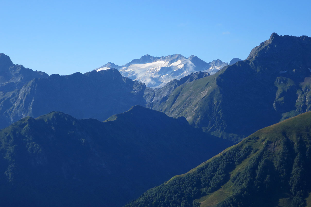
But first, a few notes. In this choice we have tried to represent the whole Pyrenees in some way, to show great mountains and not secondary or small needles, slender mountains but without obsessing over the last few metres. Sometimes a peak is nothing but the culmination of a whole massif formed by valleys and ravines of extraordinary beauty. I am thinking of Monte Perdido with Ordesa, Pineta, Añisclo, Escuaín...
We have also taken into account the history and symbolism of the mountain, which are often synonymous with beauty, and which, like a monument or a work of art, turn a pile of stones into a dream for which some have even lost their lives.
Let's not get bogged down, these are our top 10 picks.
Orhi (2,019m)
The Orhi (2,019m) is not only the first mountain to exceed 2,000 metres in altitude coming from the Cantabrian Sea, but it also surpasses the previous highest mountain, Bizkarzé (1,656m), by almost 400 metres.
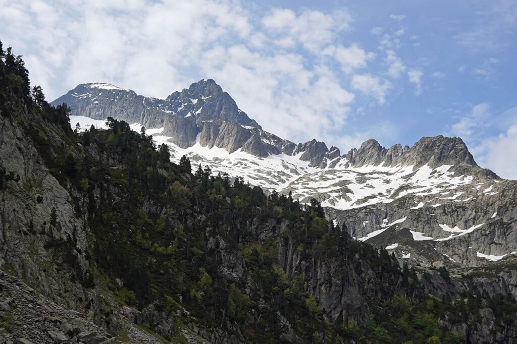
It could be said that the Orhi is the first great mountain in the Pyrenees, the first mountain in the shape of a mountain, with long, sharp edges that converge at the summit and a north face with two glacial cirques, Alüpiña and Atxurterria, along which there are several lines that are climbed in winter.
Despite its modest altitude, the Orhi is perfectly identifiable from a distance, even from hundreds of kilometres away, which gives it a certain air of a colossus.
To the north, the Orhi shows its steepest slope, dominating the Larraine valley 1,400 metres above; to the southwest, the Orhi contemplates the Irati forest as a king would from the top of his castle, with no villages or roads to tame it; to the south and east, the road to the Larrau pass provides quick access, making this route the one chosen by most to reach its summit.
Anie (2,504m)
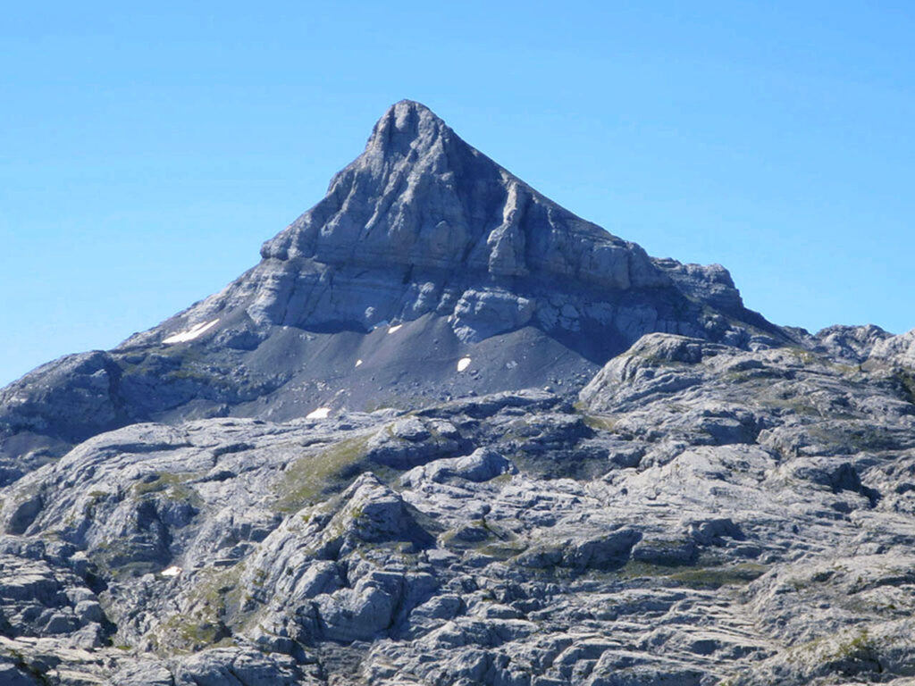
If we said earlier that for many people the first great mountain in the Pyrenees coming from the Cantabrian Sea was the Orhi, for others it would be the Anie.
The peak of Anie or Auñamendi is the highest mountain in the Larra massif and the first to surpass the 2,500m barrier from the Atlantic Ocean. It is a mountain of sublime lines, a perfect pyramid that dominates the great karst plateau of Larra, which stretches out at its feet as if it were a petrified glacier. A unmissable ascent.
The 1868 Joanne guide to the Pyrenees states that this mountain had become the Olympus for the Basques and that it gave its name to the whole Pyrenean chain. Located entirely in Béarn, but very close to Navarre and the French Basque Country, this mountain is called Aunhemendi and Auñamendi in Basque. Auña, which in Roncals means kid, would therefore be translated as "Mountain of the Kid". The same meaning as in Swahili, "ahü'ñe", but different from "ahun", which would mean, whipped by the wind.
The first recorded ascent was made by Henry Reboul in 1786, during the work that the French and Spanish governments had begun in 1784 to delimit the border. For some authors, this ascent marks the beginning of the conquest of the important peaks of the Pyrenees.
Midi d'Ossau (2,884m)
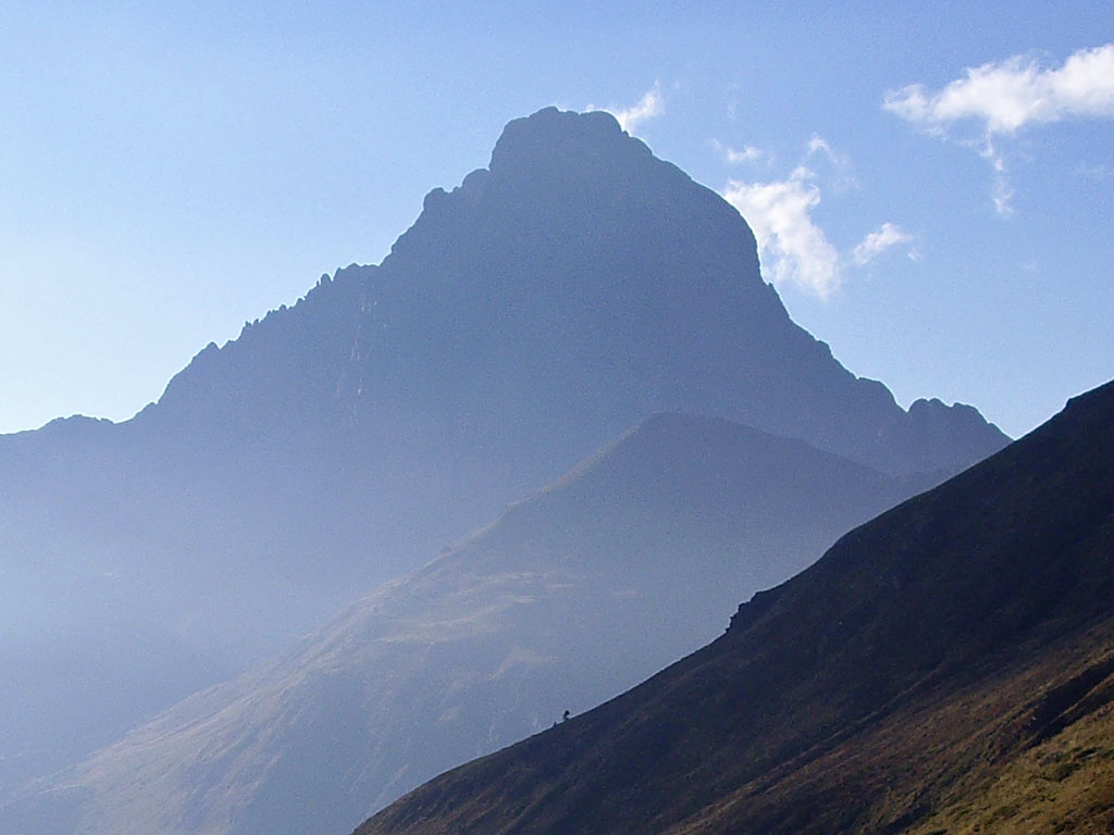
For many, the most beautiful mountain in the Pyrenees. At first glance, the Midi d'Ossau could be presented as the most inaccessible mountain in the Pyrenees (but then it is not so bad and its normal route is no more than PD), like a sort of Cervino/Mattehorn of the Pyrenees.
Its solitary and overwhelming presence, its inaccessible aspect from all angles, with disproportionate walls on all four sides, and its visibility towards the Ossau valley and, in general, towards any high point, do not go unnoticed. For this reason and more, the Midi d'Ossau was first climbed in 1782 by a shepherd from the Aspe valley, and there is no mountaineer who, on seeing it for the first time, does not feel the call to reach its summit, even though it does not reach the symbolic figure of 3000 metres.
Compact in appearance, when you approach it you discover that, in addition to the Petit Pic, the mountain is actually made up of several peaks. So, once you have climbed the Grand Pic, if you have a certain vocation for climbing, you will immediately want to walk the normals of its shady north face, climb the Petit Pic, make the 3-Point traverse, the 4-Point traverse and discover all the twists and turns that this colossal mountain has to offer beyond its walls and its summer climbs.
Balaitous (3.146m)
The Balaitous, the first major summit to surpass the 3,000-metre barrier, rises majestically on the axial axis of the Pyrenean chain, projecting vertiginous granite edges towards any of its slopes.
The most famous are the Frondellas, which is home to an elegant handful of three-thousanders; the Diablo, with the Torre de Costerillou, the most difficult three-thousander to climb; and the northwest ridge, the Aguja Lamathe.
In any case, climbing the Balaitous is not an effortless undertaking. All its routes are long, with gradients of over 1600 metres, and always with some climbing to add to the excitement. The Grand Diagonal (F+), the Latour gap (PD), the Beraldi vira (PD-) and the Neous chimney (AD-) are the normal routes.
Vignemale (3.296m)
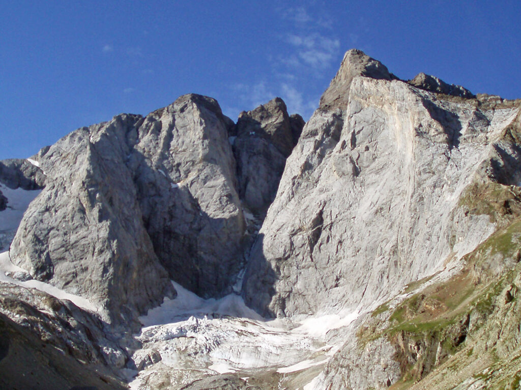
The Vignemale, or Comachibosa, is the most alpine mountain in the Pyrenees. That is exactly what it looks like, as if a little piece of the great mountains of the Alps had been torn out to be placed here.
Nicknamed the Lord of the Pyrenees, its extraordinary north face is unparalleled, 800 metres of verticality on which the most audacious and famous lines in Pyreneanism have been traced, such as the Classic North, climbed in 1933 by Henri Barrio and Robert Bellocq, and of course, the well-known Couloir de Gaube (year 1.889), the most coveted snow and ice climb in the Pyrenees, achieved by Henri Brulle, Jean Bazillac and Roger de Monts, with the guides François Bernat-Salles and Célestin Passet, and masterfully completed by the latter after carving 1300 steps and overcoming the key step of the embedded block thanks to the help of the famous Flor de Gaube ice axe, which Brulle had brought from the Oberland for the occasion.
The Vignemale massif, in terms of history, size and height, together with Monte Perdido and Maladetas, forms the trilogy of great Pyrenean massifs. The Vignemale is also the only one whose glacier, the third largest in 2016 with 37ha, retains its tongue.
It is through the Ossoue glacier that the normal route ascends, a route for which the use of ice axes and crampons is essential, which adds an extra touch of epicness to this ascent. From the south side, the Pique Longue is not visible. Towards this side, the most outstanding features are the marble walls of Montferrat towards the cirque of Labaza, where it climbs upwards. the normal route through the south through the Moskowa corridor, through which it was conquered for the first time.
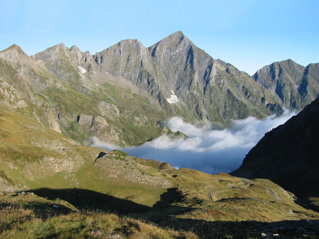
Monte Perdido (3.348m)
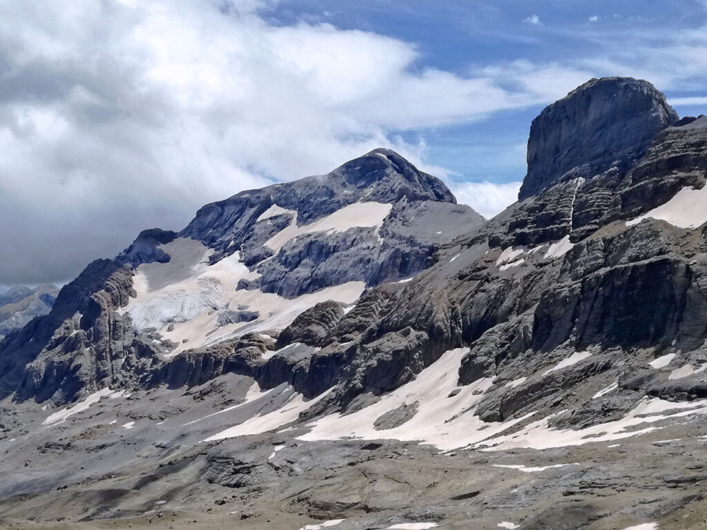
"When you have seen the most beautiful of the granite mountains (Mont Blanc), you have yet to see the most beautiful of the limestone mountains: Monte Perdido". (Louis Ramond de Carbonnières).
Nicknamed the Pyrenean giant, Monte Perdido, or Punta Treserols, is the third highest mountain in the Pyrenees (fourth, taking into account Punta d'Astorg) and the highest limestone mountain on the European continent. It is therefore not surprising that people continue to explore here in search of the world's deepest chasms.
The Pyrenees-Monte Perdido complex was declared a UNESCO World Heritage Site in 1997, although the beauty of this place had not gone unnoticed, and long before that, in 1918, the Ordesa y Monte Perdido National Park had already been created, the second oldest in Europe after the "Montaña de Covadonga", in the same year.
Monte Perdido is an enormous mountain in the Pyrenees. On its north face, hidden towards France (hence its name) hangs the second largest glacier in the Pyrenees. At its feet, Lake Marbore, which collects the waters of the glacier, flows into the Pineta valley in a succession of waterfalls that are impossible to describe. A U-shaped valley as deep as few, or rather, as none. To the south, the Garganta de Escuaín gorge, the Añisclo canyon and the Ordesa valley complete a landscape covered with pine, fir and beech forests that make this area one of the most popular destinations in the whole mountain range.
On a historical note, although the first documented ascent is by Ramond de Carbonnières in 1802, it is more than likely that this ascent was made in 1802. could have been made 9 years earlier by Vicente de Heredia or by a shepherd in the area.
Neouvielle (3,091m)
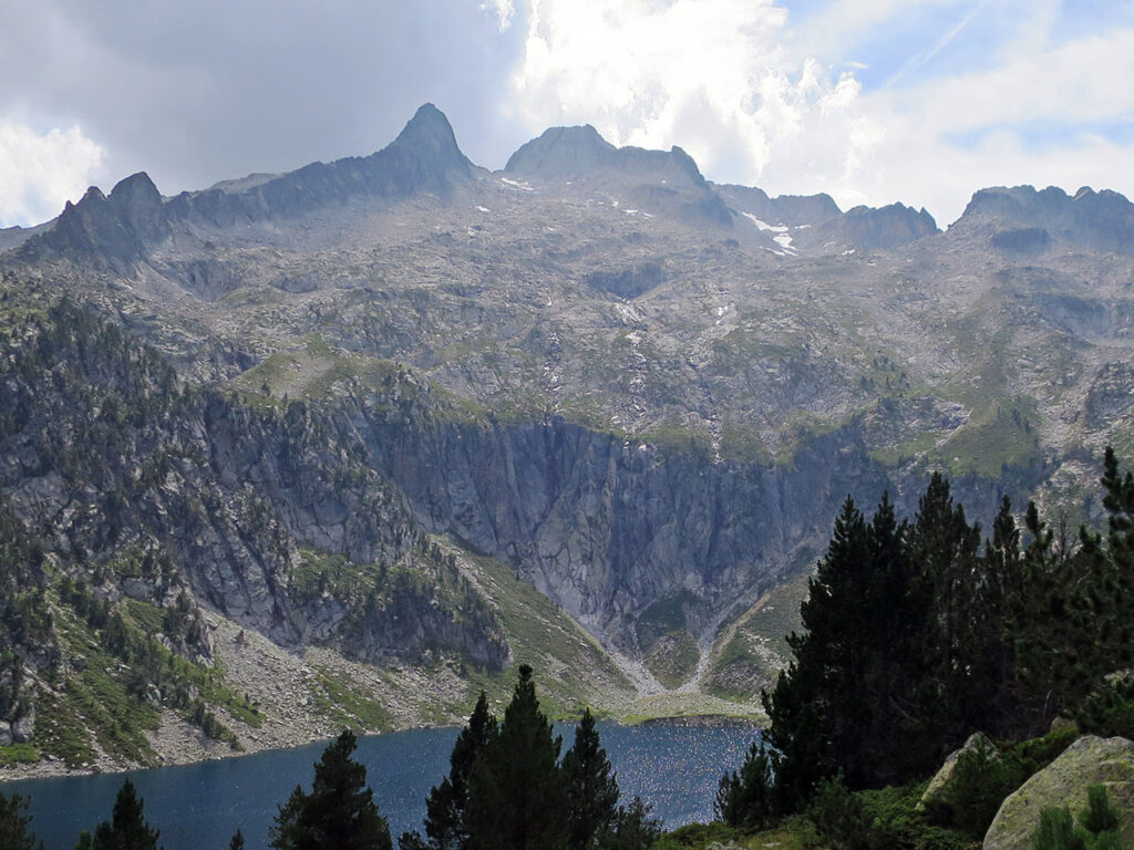
The Pic de Neouvielle (3,091m), without being the highest, is the most visible of the massif's three peaks. Its craggy silhouette with an impregnable appearance, seen from the lakes of Aumar and Aubert, behind the sharp Ramougn peak (3,011m), is the most recognisable symbol of the whole massif. The beauty of this peak, together with the low difficulty of the route, make it the most visited of the three peaks in the massif. It is a highly recommendable peak for beginners or simply to enjoy the exceptional natural surroundings.
The Neouvielle massif, a nature reserve since 1936, is one of the most beautiful granite massifs in the Pyrenees and is located at the eastern end of the French Pyrenees National Park. Its interior is home to countless lakes (some 700) and extremely jagged peaks (19 of them above 3,000m) from which endless granite ridges jut out. A few glacial relics remain, the most significant of which is the Pays Bache glacier on the Pic Long. Those that used to surround the Neouvielle (in Occitan old snow) are today only permanent snowfields that no longer live up to their name.
As we have said, the normal route to the Neovuielle from Lake Aubert, via the Barris Gap and what is left of the glacier, is a highly recommended "easy" route. If you are into "rock and roll", an interesting option is to join the Neouvielle with the Pointe Ramougn (PD+). Another highly recommended option, but only for climbers, is the Trois Conseillers ridge. One of the most prestigious and "easy" (D-) climbs in the Pyrenees. One of those so-called "must climbs", a classic among classics, with quality rock and a great atmosphere.
Mont Valier (2.838m)
What a majestic mountain. Its silhouette is unmistakable and, although it is not the highest peak in the region, "Le Seigneur de l'Ariege" is the most emblematic and sought-after mountain in the whole area.
Located in the Couserans, in the west of the Ariège, it forms, together with the peaks of Mauberme and Barlonguéra, the most desirable trident of peaks in the area.
Situated slightly to the north of the axial axis of the Pyrenees, it is one of the great Pyrenean peaks in its own right. Its two main slopes, those that flow towards the French valleys of Riberot (West) and Estours (East), drop 1600 metres. To the south, towards the Noguera Pallaresa, in the Aran valley, it is also an accessible mountain, where it drops 1200 metres. The most popular routes run from the Perosa bridge, to the south, and from the Estagnous refuge, to the north, in the heart of the Pass'Aran route.
According to legend, its name comes from the bishop Saint Valerius, the first person to reach its summit in the 5th century.
Els Encantats (2.748m)
Despite not reaching an altitude of 3,000 metres, despite not even being one of the highest mountains in the Aigüestortes i Sant Maurici National Park, Els Encantats, as its name suggests, has an incomparable charm that makes it part of this list.
According to legend, on the day of Sant Maurici, two shepherd brothers from Espot, Cristobal and Esteban, decided to go up to hunt isards, skipping mass. Apparently, that year there were few of them and they thought that if they got up early, they could be back by midday with a catch to celebrate this important day. The man upstairs must not have liked this and at the moment of the consecration, with the whole village in the chapel, there was a roar that shook the whole valley. The mountain had cracked in two, transforming these two brothers into rock.
Of the twin peaks, the highest, the Gran Encantat, is also the easiest (PD). The Petit Encantat, being somewhat more difficult (AD), because it is lower, was climbed for the first time a year later, in 1902. By that time most of the main 3,000m peaks had already been climbed.
The beauty of this double summit is enhanced by its setting, surrounded by fir forests, in a place with the highest concentration of lakes in the whole of the Pyrenees. Its position overlooking the valley, reflecting its silhouette over the Sant Maurici lake, is one of the most attractive images of the Pyrenees, but at the same time, one of the most crowded places in the Pyrenees.
Pedraforca (2.507m)
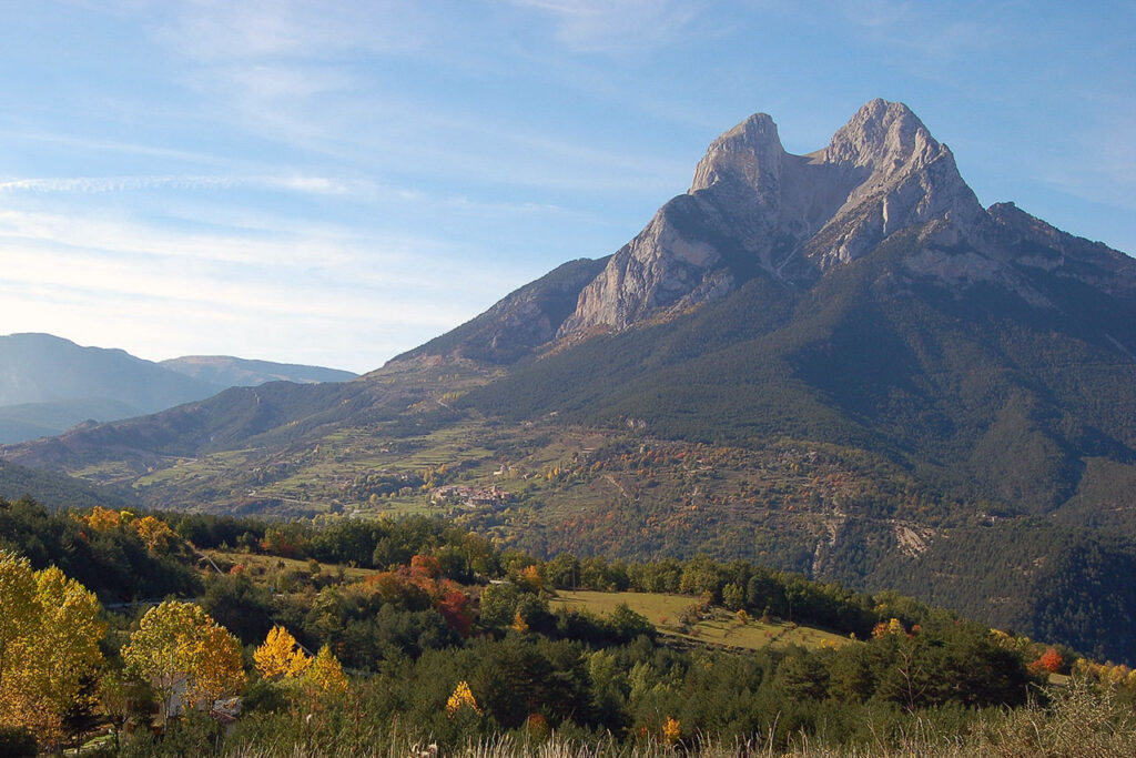
Pedraforca is one of the most emblematic mountains in Catalonia and one of the most spectacular in the Pyrenees. Although it is included in the Cadí-Moixero Natural Park, the Pedraforca massif has a structure of its own, broken off to the south of this elongated mountain range.
The structure of Pedraforca is very peculiar. It is formed by two parallel ridges with an east-west orientation, joined by the neck of the Enforacadura.
From the east, from Saldes, Pedraforca shows its best-known silhouette, which is revealed as a limestone mountain with twin peaks emerging above the coniferous forests.
The north ridge, where the highest peaks are located, Pollegó Superior (2,507m) and Calderer (2,497m), is home to its famous wall, hostile and bleak, several kilometres long and with a maximum height of 600 metres. Here, from the 1930s onwards, Catalan climbers, who were already at a high level for the time, began to open the prestigious climbing routes on this peak, the great classics of our times. One of its pioneers was Lluis Estasen, to whom the refuge on the north face is dedicated today.
The south ridge, that of Pollegó Inferior (2,445m), also stands out for its verticality and the size of its wall, with some routes that exceed 400 metres of climbing.
Nowadays, the normal routes to Pedraforca are some of the busiest in the Pyrenees, so if you want to enjoy the mountain with a little more solitude, it is best to avoid July, August and other special dates during the good weather.
Fastpacking is not about going faster. It's about going lighter.
If you come from classic trekking, this is the next step: learning to move with less weight,
more fluid and enjoying every kilometre more.
Join the Outsiders Newsletter and start discovering what lightness feels like.