Crestas del Pirineo
Pirineos y montaña 📩
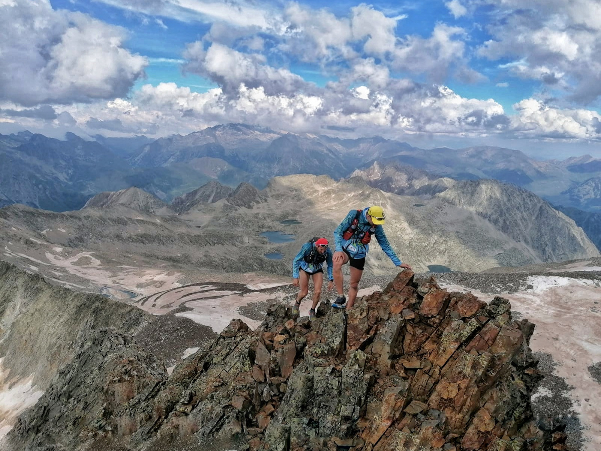
Aquí 🔥En el Pirineo podemos encontrar una gran cantidad de crestas, de todo tipo de dificultades y con una gran variedad de atractivos que permiten enlazar varias cimas de más de 3.000 metros en una misma jornada. En este artículo nos centraremos en como iniciarse en éste mundo, detallando cinco propuestas de crestas de menor a mayor dificultad, cuyo ascenso permite ascender varios Tresmiles en diferentes sectores del Pirineo.
👉 Una cresta es un tramo de arista que generalmente une una cima con otra, aunque podemos encontrar diferentes vías que culminan en una única cumbre. La dificultad de cada una de estas crestas puede ser muy relativa, aunque siempre se tendrán en cuenta una serie de factores como pueden ser la calidad de la roca, el grado de exposición, o si hay que efectuar algún paso que requiera de cierta técnica de escalada.
A continuación proponemos cinco crestas ideales para iniciarse en este tipo de recorridos. Todas ellas encadenan varias cimas de más de 3.000 metros como atractivo principal, ya que es la manera más rápida de poder ascender varios Tresmiles en la misma actividad. La dificultad de las crestas propuestas irá aumentando a medida que vamos avanzando, a pesar de que todas ellas pueden efectuarse sin necesidad de utilizar material propio de escalada, pero sí que requieren un cierto dominio y experiencia en este tipo de terrenos.
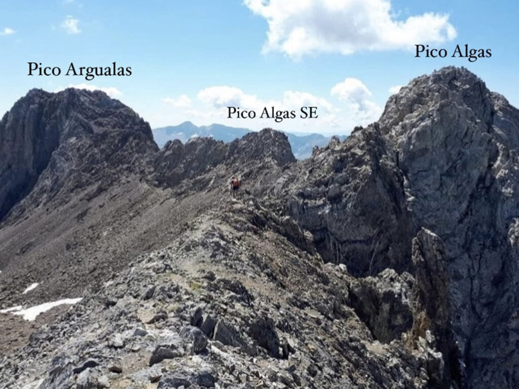
1. Cresta Garmo Negro – Argualas
| 📋 Ficha Técnica: |
| Inicio: Balneario de Panticosa Distancia: 12 Km. Desnivel positivo: 1.600 m. Dificultad: Fácil Sup. (F+) Tresmiles ascendidos: Garmo Negro (3.061), Algas Norte (3.032), Pico Algas (3.036), Algas SE (3.023) y Pico Argualas (3.046) |
Partiendo desde el Balneario de Panticosa, se realiza la clásica ascensión al Garmo Negro, cuyo recorrido no plantea ninguna dificultad. Desde la cima, se pierde altura en dirección Norte hasta alcanzar el collado del Algas, a 2.960 metros, y desde dónde efectuando una corta subida se llega sin complicaciones a la cima del Algas Norte. A partir de este punto se inicia una corta cresta que no plantea grandes dificultades y cuya progresión es muy evidente hasta llegar a la cima del Pico Algas. En este punto la cresta se vuelve más estrecha, aunque la calidad de la roca es muy buena y el avance no plantea grandes dificultades. Existe la posibilidad de descender unos metros en busca de un sendero que flanquea la cresta por debajo, aunque progresar por el filo resulta más atractivo y permite ganar soltura en terrenos más técnicos. La cresta presenta algún tramo algo expuesto, aunque los pasos son sencillos y la calidad de la roca trasmite seguridad.
Una vez alcanzada una brecha, aparece un evidente sendero marcado con hitos que nos lleva directamente a la cima del Pico Argualas, 3.046 metros. El descenso se puede realizar directamente hasta el Collado de las Argualas, enlazando así con el itinerario de subida desde el Balnerario de Panticosa.
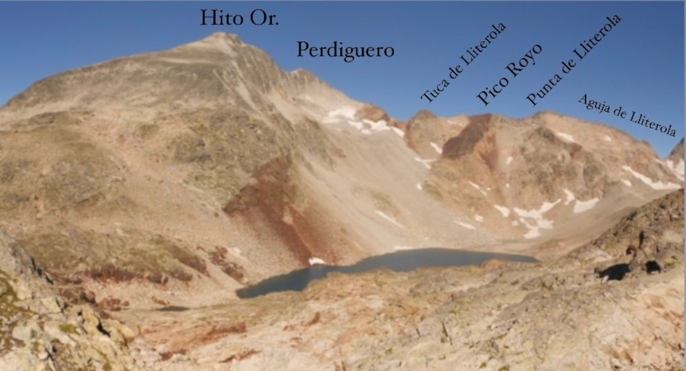
2. Cresta del Perdiguero
| 📋 Ficha Técnica: |
| Inicio: Valle de Lliterola Distancia: 18 Km. Desnivel positivo: 1.800 m. Dificultad: Fácil Sup. (F+) Tresmiles ascendidos: Hito Or. Perdiguero, (3.171) Pico Perdiguero (3.222), Hito Occ. Perdiguero (3.176), Tuca de Lliterola (3.095), Pico Royo (3.121), Punta de Lliterola (3.132), Aguja de Lliterola (3.028) |
Iniciando el ascenso desde el Valle de Literola, se asciende al Perdiguero por su ruta habitual. Para alcanzar su cima, inevitablemente se supera la cima del Hito Oriental del Perdiguero, otro Tresmil catalogado en la lista oficial. Desde la cima del Perdiguero, cabe la opción de descender unos metros en busca del Hito Occidental del Perdiguero, a pesar de que posteriormente habrá que regresar de nuevo a la cima del Perdiguero para iniciar el cresterío.
De vuelta al Perdiguero, se desciende en dirección Norte en busca del Collado superior de Literola, por un terreno algo descompuesto pero que no presenta grandes complicaciones. Desde el collado, tan solo queda superar una corta subida hasta alcanzar la Tuca de Literola, 3.095 metros. El terreno es muy practicable, con un trazado sendero que permite culminar el Pico Royo, 3.121 metros, y la Punta de Literola, 3.132 metros, sin problemas. A partir de aquí, la cresta se vuelve algo más estrecha, efectuando cortos flanqueos por la vertiente del Ibón Blanco de Literola para esquivar los tramos más delicados. Poco a poco se va perdiendo altura, el terreno es practicable y los hitos van indicando el itinerario correcto hasta llegar a la corta trepada que te deposita en la Aguja de Literola, 3.028 metros. En este punto tan solo queda descender al Collado Inferior de Lietrola y regresar en busca del valle que concluye con el itinerario de subida.
Cabe la opción de realizar la ruta circular utilizando el contiguo Valle de Remuñe como vía de ascenso o descenso, a pesar que luego habrá que remontar los 3 Km. de carretera que unen un valle con el otro.
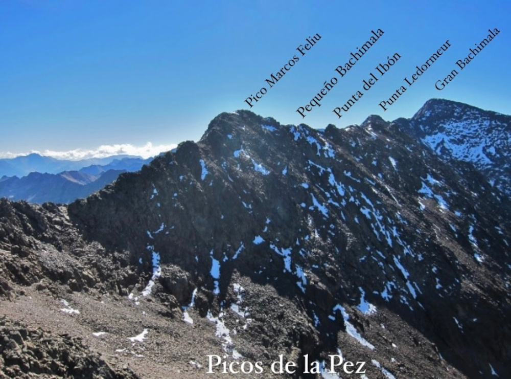
3. Cresta del Bachimala
| 📋 Ficha Técnica: |
| Inicio: Refugio de Tabernés Distancia: 18 Km. Desnivel positivo: 1.800 m. Dificultad: Poco Difícil. (PD) Tresmiles ascendidos: Pico de la Pez (3.024), Pico del Puerto de la Pez (3.018), Pico Abeillé (3.029), Pico Marcos Feliu (3.057), Pequeño Bachimala (3.061), Punta del Ibón (3.100), Punta Ledormeur (3.120), Gran Bachimala (3.177), Punta del Sabre (3.136) |
Partiendo desde el refugio de Tabernés, se asciende por el Barranco de Bachimala en busca de los Ibones que dan acceso al circo que forma toda la cresta. Subiendo por una canal de roca algo descompuesta se alcanza rápidamente la corta arista que culmina en los Picos de la Pez. Este es el tramo que presenta mayor dificultad de toda la cresta, con algún paso de IIIº que se supera con cierta agilidad. Existe la opción de perder altura por la vertiente de los lagos de Bachimala para luego remontar por un sendero descompuesto y enlazar de nuevo con la cresta.
Una vez en la cima del Abeillé, 3.029 metros, las dificultades disminuyen, y la cresta se suaviza para ir sumando las cimas más próximas, Pico Marcos Feliu, Pequeño Bachimala, Punta del Ibón y Punta Ledormeur. En este punto, nos encontramos con una placa lisa de IIº que debemos descender en busca de la brecha que separa la Punta Ledormeur y el Gran Bachimala. El destrepe no presenta dificultades, a pesar de que resulta algo expuesto y requiere de cierta habilidad en este tipo de terrenos.
Desde la brecha hay que prestar mucha atención a los hitos, puesto que el terreno resulta muy descompuesto y la vía de ascenso al Gran Bachimala no es evidente. La vía más practicable consiste en una estrecha canal, bastante descompuesta, que se encuentra a la izquierda en el sentido de la marcha. Una vez en el Gran Bachimala, se sigue la cresta, ahora ya muy evidente, en dirección a la Punta del Sabre, 3.136 metros. En general la cresta no presenta grandes dificultades técnicas, a pesar de que la calidad de la roca no es muy óptima y hay que ir con mucho cuidado en la progresión. El descenso se realiza por la ruta normal que sigue el itinerario del Collado Señal de Viadós.
4. Cresta de la Munia
5. Cresta Espadas
Recomendaciones para iniciación a las Crestas del Pirineo
Una vez finalizada la propuesta de 5 crestas para iniciarse en el Pirineo, hay que tener en cuenta varios factores.
⚠️ La dificultad de una cresta puede resultar muy relativa y personal, a pesar de que todas ellas estén catalogadas y clasificadas en diferentes niveles, todas ellas requieren de cierta experiencia en alta montaña, puesto que transcurren por terrenos salvajes, de mucha piedra, y que por lo general son tramos lentos que nos pueden llevar varias horas para recorrerlas.
❕ A pesar de que su nivel no lo requiera, se recomienda llevar el equipo básico de escalada en todas ellas, para evitar o prevenir cualquier tipo de incidente. El casco, unas buenas botas o zapatillas con buen agarre, una cuerda con sus respectivos materiales (mosquetón, cintas, reverso…), pueden ayudarnos a garantizar la seguridad en ciertos tramos o pasos de cualquiera de estas crestas.
📅 La época del año que se aconseja para poder intentar hacer estos itinerarios es de mayo a septiembre, consultando siempre en las páginas específicas de montaña cuáles son las condiciones y en qué estado se encuentra la cresta.