Volcán Telica – Nicaragua
Pirineos y montaña 📩
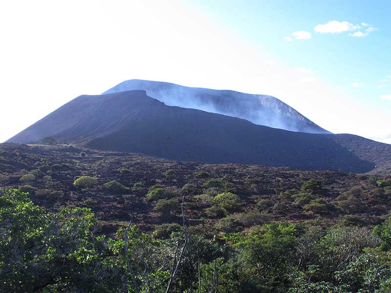
Aquí 🔥A 1.060 metros de altura, el volcán Telica se sitúa en el departamento de León, Nicaragua. Está ubicado en la Cordillera de los Maribios sigue en activo y en el año 2018 ocurrió la última erupción en la que lanzó un columna de humo de 500 m, fragmentos de roca, materia arenosa y gases.
Te puede interesar: Los 12 mejores trekkings en América Central »
Guía práctica para el senderista
El lugar más indicado para hospedarse antes de comenzar la ruta es León. Desde allí se puede tomar un autobús que les trasladará a San Jacinto, el lugar donde comienza la ruta hacia la cima. El recorrido hasta la localidad es de unos 10 km.
Es posible realizar el recorrido de forma individual o contratando el servicio de un guía. Preguntando a las personas encargadas de los cultivos de la zona se puede llegar hasta la cima sin gran complicación. En el caso de que se realice la ruta con un guía, este les mostrará algunos lugares de interés durante el camino además de ofrecer información sobre la fauna y flora d la zona. Se necesitan unas 5 horas y media para poder realizar toda la ruta.
En la cima se puede visualizar un boca de cráter humeante de unos 700 metro de ancho y 120 m de profundidad. Si se observar dentro del cráter se puede ver el magma rojo brillante y las nubes de gas de azufre.
A pocos metros de del cráter es posible poder acampar, es el sitio ideal para poder pasar la noche.
La ruta se puede realizar en cualquier época del año ya que las temperaturas no varían prácticamente durante todo el año.
LEE TAMBIÉN: Ocho ascensiones a volcanes a lo largo del mundo que no te puedes perder »
Consejos para el senderista
Al ser una montaña de gran altura, gran altura serán necesarias ropa de mucho abrigo. Durante el la ruta las temperaturas irán descendiendo en conforme la altitud va aumentado. En el caso de que la ruta se vaya a realizar de noche, las prendas deberán de ser de mucho abrigo. En el caso de que se haga durante el día, las prendas podrían ser más ligeras pero serán necesarias prendas de abrigo para la cima. Es imprescindible para todas las personas llevar zapatos cómodos y resistentes para poder caminar.
En lo referido a los alimentos y bebidas es importante calcular bien las raciones que serán necesarias. Aquellas personas que hayan la ruta en un único día deberán llevar al menos 2 litros de agua. Las personas que por su parte decidan acampar y descender al día siguiente necesitarán de bebida para subir, pasar la noche y descender la mañana siguiente, por lo que serán necesarios al menos 4 litros. En el caso de los alimentos, las personas que hagan la ruta durante el día deberán llevar algunos bocadillos para poder comer. Las personas que hagan la ruta en dos días requerirán de un mayor número de alimentos.
Aunque no haya grandes problemas para poder seguir el camino, para que no se corra ningún riesgo se recomienda hacer uso de un dispositivo GPS. De esta en el caso de que se sufra alguna lesión o cualquier tipo de problema los servicios de rescate podrán actuar con gran rapidez. Aunque en el caso de las personas que no estén experimentadas en realizar rutas de senderismo sería mejor idea contratar a un guía.
Es importante planear el viaje con antelación ya que las condiciones meteorológicas harán que la ruta sea más sencilla o complicada. Para poder subir a la cima será importante tener en cuenta si hay lluvias o no y el viento. De todas formas sí que puede haber algunas partes del sendero en las que no siempre esté muy claro cuál es la ruta a seguir.
Los lugareños solo hablan español por lo que se recomendaría tener un conocimiento básico del idioma. Además es bastante complicado encontrar a algún lugareño para poder preguntarle por la dirección del sendero.
Aquellas personas que no estén experimentadas en rutas de senderismo o no tengan muy buena orientación deberían contratar a un guía local en San Jaciento para poder subir a la cima. Los que decidan hacerlo de forma individual tendrán que preparar la ruta con una o dos horas adicionales por si se pierden para poder retroceder.
Se recomienda realizar la ruta de noche, así podrá tener una vista singular del volcán. Los colores rojos del magma son muchos más impresionantes cuando el alrededor está completamente a oscuras.