El pico Arnales ¿un tresmil? (Primera parte)

Pirineos y montaña 📩
Aquí 🔥Al igual que en la cordillera de los Himalayas los reyes son los ochomiles y en los Alpes son los cuatromiles, en los Pirineos este selecto club lo forman los “tremiles”. Y no, no es que por debajo de esta simbólica cifra no haya montañas con más carácter que muchas de las que figuran en la/las listas de tresmiles, pero es que eso de ser un tresmil tiene más “caché”.
Como ya sabéis, el número de tresmiles, los que cumplen con la regla de superar los tres mil metros de altitud y tener una prominencia de más de 10 metros, no es definitivo. Si bien, en los últimos años la cifra se ha estabilizado entre 212 y 217 aproximadamente. ¿Que cuantos son exactamente? Aún no lo podemos afirmar, pero si hay que decir un número, resulta especialmente actual y fiable la información publicada en la web de “Los Cazafantasmas”, que ahora mismo deja la cifra en 216, tras la inclusión de la Punta de la Brecha Superior de Llosás.
Si visitáis dicha web, podréis ver que justo a continuación del listado de los tresmiles figura un segundo listado. En el se encuentran los picos que en algún momento fueron catalogados como tresmiles y después resultaron no serlo. Entre ellos, unos pocos aspirantes a la espera de que su caso sea revisado reclaman «justicia”, como el pico Arnales, apartado del listado por 10 centímetros y que en algunas publicaciones se incluye previa advertencia.
Pues bien, con los nuevos datos disponibles a fecha de 22 de febrero de 2022 trataremos de darle una nueva oportunidad a este pico situado cerca de los Baños de Panticosa, o al menos, estrechar el cerco más si cabe.
El caso “Arnales”
Una primera búsqueda en internet pone rápidamente de manifiesto la disparidad de cifras en torno a la altitud de este pico, oscilando entre los 3.006 metros con los que aparecía en la lista de Buyse y los 2.996m con los que figura y figuraba en los mapas del IGN.
Primera comprobación: estudio visual de los mapas del IGN
La primera comprobación obligatoria será pues, comprobar visualmente cual es la altitud con la que figura el Arnales en los mapas de los organismos oficiales. En el caso del visor Iberpix del IGN la cifra que aparece continúa siendo 2.996m, la misma que aparecía hace varios años obtenida por estereocorrelación automática del vuelo fotogramétrico. Una método que en zonas con mucho relieve presenta por lo general, mayor error que en zonas planas.

Una segunda comprobación de este mismo mapa (MTN25) la realizamos a través del Centro de Descargas del CNIG. Según se indica, la hoja 0145 en la que se encuentra el pico Arnales está actualizada en marzo de 2.021, sin embargo, sigue sin ofrecernos nada distinto a lo aparece en el visor. Una última comprobación en el visor Iberpix la realizamos sobre la capa lidar, obteniendo un resultado de 2.999m al pasar el cursor por la zona.
Segunda comprobación: mapas SITAR
El segundo mapa comprobado de organismos oficiales es el Mapa Topográfico de Aragón a escala 1:5000 (MTA5). Lo podéis consultar en el visor IDEARAGON. Aquí el Pico deros Arnals aparece con una altitud de 3.000,00m.
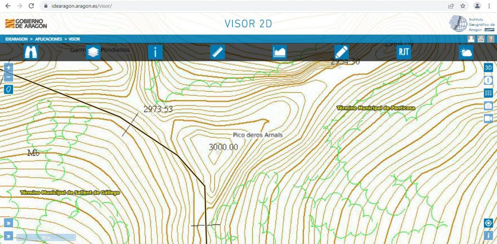
Una cifra sospechosamente redonda que nos invita a pensar precisamente en eso, en un redondeo de los decimales, más aún cuando comprobamos que el resto de tresmiles de la zona aparecen con dos decimales. La misma cifra aparece en el Boletín oficial de Aragón, en el documento Orden VMV/914/2020 por el cual se aprueba en 2020 la última modificación del nomenclator de los tresmiles de Aragón de 2017.
Tercera comprobación: MDT Lidar
No quedando conformes con los resultados obtenidos al estudiar la cartografía de Aragón y del IGN, lo siguiente es ir un paso atrás para estudiar el Modelo Digital del Terreno (MDT). El producto previo del que posteriormente se obtiene el relieve para el correspondiente mapa topográfico. En este caso, la hoja que buscamos es la número 0145 correspondiente al Mapa Topográfico Nacional (MTN).
En la IDEARAGON podemos descargar los MDT de 2012 y 2015, mientras que en el Centro de descargas del CNIG se puede descargar el MDT de 2010. Después de las pertinentes comprobaciones averiguamos que el MDT de 2015 de Aragón es el mismo que el MDT de 2010 del IGN, correspondiente a la primera cobertura lidar (2009-2015) del Plan Nacional de Ortofotografía Aérea (PNOA).
De modo que tenemos dos MDT diferentes (2012 y 2015 según la nomenclatura de Aragón) generados a partir de la clase 2 (terreno) de la nube de puntos lidar que luego veremos.
Para verlo de un modo muy gráfico, a partir del MDT hemos generado curvas de nivel a cada metro. Por otro lado, teniendo en cuenta que el paso de malla es de 5 metros, se han tomado una serie de puntos en la zona del Arnales a dicha distancia (tomarlo cada menos no tendría sentido). El resultado puede verse en las siguientes imagenes:
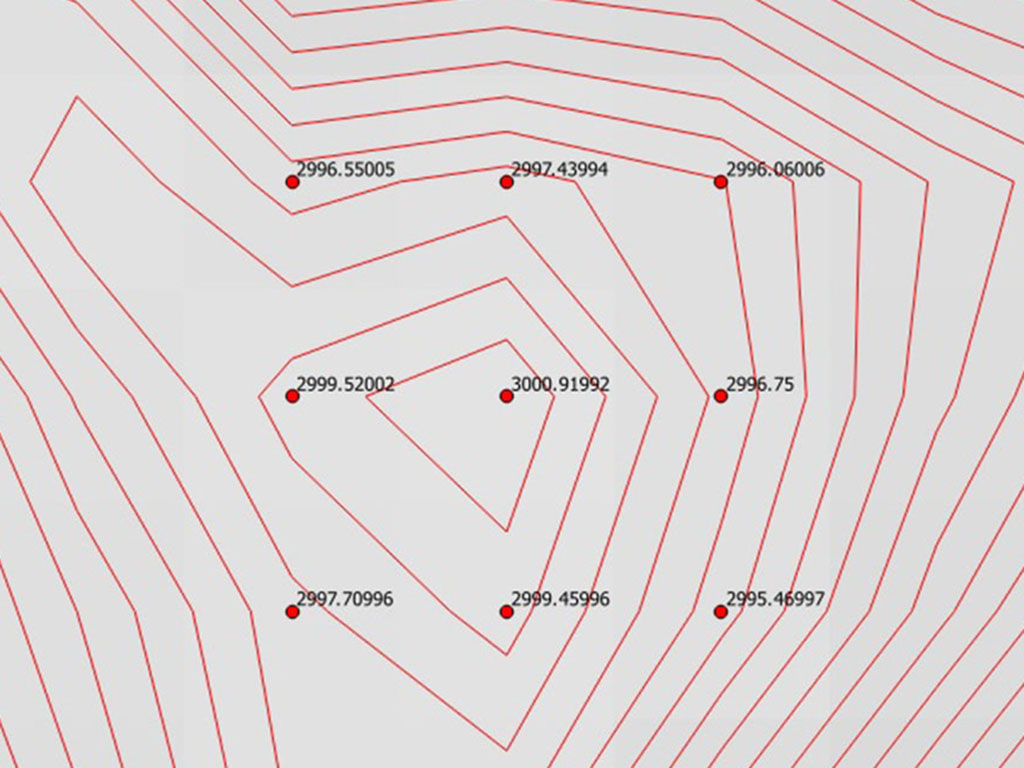
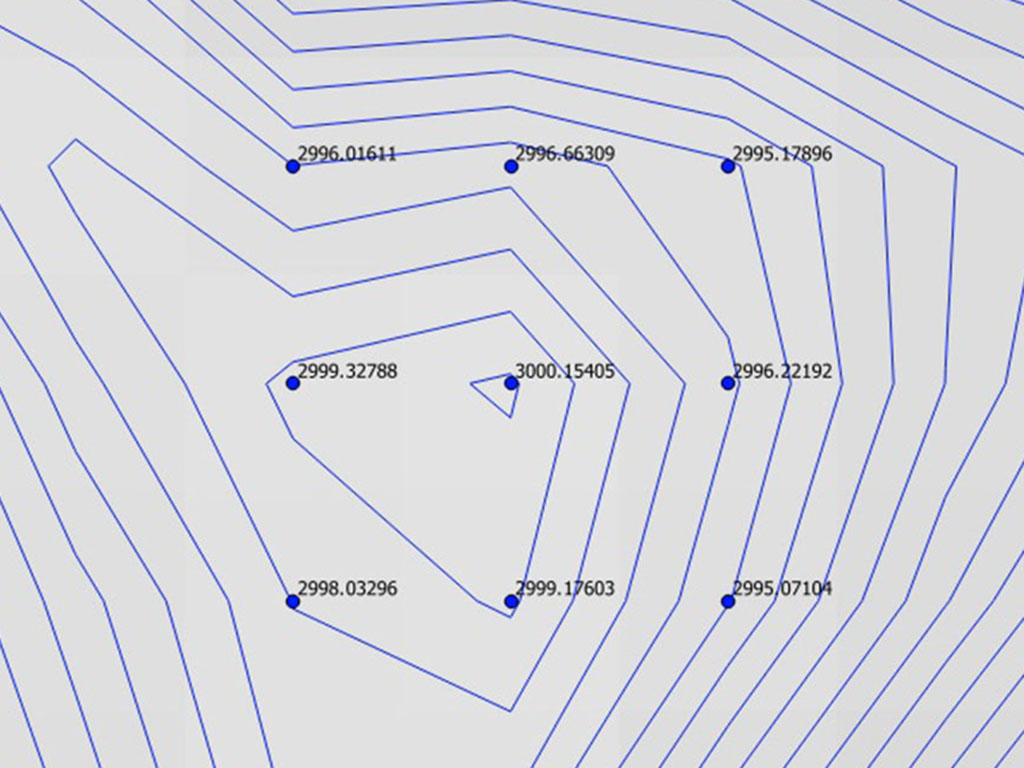
Mientras que el MDT2012 ofrece una altura máxima de 3000,92m, en el MDT de 2015 la altura máxima es de 3000,15m. Lamentablemente, sobre las especificaciones técnicas del MDT2012 de Aragón no hemos encontrado información. Del MDT de 2015, que es en realidad el vuelo de 2010 del PNOA, en las especificaciones técnicas publicadas por el IGN se señala que el error RMSE Z del MDE (lo mismo para el MDT) es de 50 centímetros.
En conclusión, según lo visto en el MDT2015 de Aragón (del MDT de 2012 nos falta información) no podemos afirmar con rotundidad que el pico Arnales sea un tresmil, ya que aunque se sobrepasa en 15 centímetros los 3000 metros, el RMSE Z es de 50 centímetros.
Cuarta comprobación: nube de puntos lidar
Como en cualquier producto derivado, la generación del MDT implica una perdida de información. Ya solo nos queda recurrir al producto más básico disponible publicamente, la nube de puntos lidar, que se distribuye en ficheros de 2kms x 2kms y que entre otras cosas ya viene clasificada, cosidas las pasadas y transformadas las alturas elipsoidales a ortométricas (geoide adaptado a España EGM08-REDNAP).
La nube de puntos se puede descargar en el IDEARAGON o en el Centro de descargas del CNIG. En ambos casos se trata del mismo archivo y corresponde al vuelo del año 2010 del PNOA. Para el caso del Pico Arnales solo está disponible la primera cobertura LIDAR del PNOA (2008-2015). Es decir, se garantizan al menos 0,5 puntos por metro cuadrado con un error RMSE Z que de forma general será inferior a 40 centímetros y estará por debajo de 80 centímetros en el 95% de los casos.
Para el estudio nos hemos quedado únicamente con los puntos de la clase terreno, la que se utiliza para generar el MDT. Haciendo zoom a la zona de estudio tenemos el siguiente resultado:
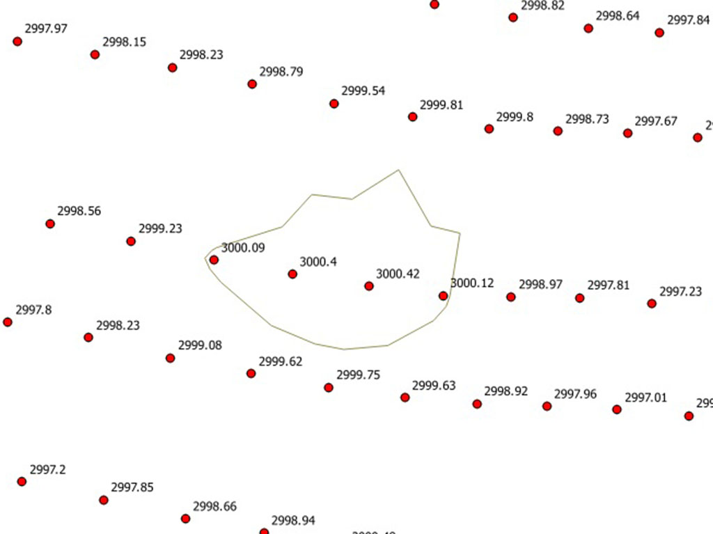
Esta vez sí, el resultado es más concluyente pero no definitivo. Se observan cuatro puntos por encima de 3000 metros (dos de ellos 40 centímetros por encima) y un buen número de puntos cercanos a esta cifra. Por tanto, se descarta la idea de que el punto más elevado se deba al hecho de haber caído sobre un gran hito u otro tipo de señal humana, ya que entre el primer punto y el cuarto que supera los 3000 metros, hay más de tres metros de distancia. Además, no se descarta que haya zonas más elevadas entre punto y punto, donde no tenemos información.
Conclusión final:
Aunque no se puede afirmar con rotundidad que el Arnales supere los tres mil metros, en la nube de puntos lidar, la base para obtener las altitudes en la cartografía, existen datos que apuntan claramente a que se trata de un tresmil, siendo su altura de 3000,42m.
Una comprobación que en un futuro resultará prácticamente definitiva se podrá realizar cuando se publiquen los datos del vuelo de la segunda cobertura Lidar, con precisión de 20 cms. Mientras tanto, la única opción para resolver definitivamente este asunto pasa por subir con un receptor GNSS de doble frecuencia y tomar mediciones con precision inferior a 5cms.
Te puede interesar:

El Arnales (3.001,37m), definitivamente un tresmil. Un grupo de 5 topógrafos denominado «Sostremetries» sube hasta la cima del Arnales con un receptor GNSS de doble frecuencia para determinar la verdadera altura de este «nuevo-viejo» tresmil.