Wonderlan Trail – Washington, EEUU
Pirineos y montaña 📩
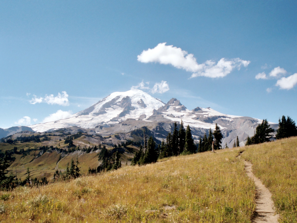
Aquí 🔥El sendero de Wonderland rodea el Monte Rainer, el pico más alto de la Cordillera de las Cascadas del Pacífico Noroeste. La ruta se sitúa en el Parque Nacional Mount Rainer en Washigton, EE.UU.
Para poder realizar la ruta se necesitan como mínimo 10 días aunque le recomienda hacerlo en 12 días. En total consiste en una caminata de uno 150 km.
Al sendero se puede acceder con mucha facilidad. Tiene cuatro puntos de comienzo desde la carretera: Longmire, Isput Creek, Mowich y Sunrise. A sus alrededores existen otras entradas pero son para realizar excursiones de un día.
Guía práctica para el senderista
El recorrido tienen una única ruta en prácticamente la mayoría del tiempo. Sin embargo en el lago Mowich, los senderistas pueden elegir si seguir de Wonderlan a Ipsut Creek o a Spray Park. El kilometraje de ambas rutas es similar, el paisaje es lo que cambia. Spray Park consiste en grandes praderas, por lo que Ipsut Creek son bosques repletos de árboles.
A la hora de dormir, no es posible acampar en cualquier sitio. Es por ello que existen 18 campamentos durante el recorrido, pero fuera de las pistas de Wonderland y dos en Spray Park Route. Cada campamento tiene un inodoro de compostaje y una fuente de agua. Dentro de la pista es posible acampar en tres sitios. Todos ello cuentan con agua corriente, duchas, electricidad y se cobra una tarifa por uso. Existe también una zona de acampada dentro del campo. Aquí lo que se permite es seleccionar un espacio para acampar dentro de una zona.
Como es una zona rodeada de montañas la nieve es visible prácticamente durante los 12 meses del año. Se recomienda hacer esta ruta en los meses de primavera y verano.
La ruta permite conocer todo tipo de paisajes desde bosques, hasta prados, glaciares y campos de nieve. Una de las formas de hacer el recorrido de forma diferente es realizándolo de noche. Aunque no sea posible disfrutar del paisaje, el cielo estrellado puede es un buen compañero de ruta.
La mayoría del tramo del recorrido se realiza en solitario. El número de senderistas que hay se despliegan por las diferentes rutas. Alguna de las rutas que contempla Eonderland Trail suele tener mayor afluencia de personas, pero por lo general es un recorrido en solitario.
Como la ruta consiste en dar la vuelta a la montaña, es posible conocerla en 360º.
Es necesario contar con un permiso para poder realizar la ruta. La solicitud de los permisos suele comenzar en el mes de abril. En el caso de que no se solicite el permiso con antelación lo que se recomienda es acudir a Longmire, Isput Creek o Sunrise para que un guardabosques le ayude a crear una ruta.
Consejos para el senderista
Hay que tener en cuenta que la ruta se va a realizar andando. Aunque la ruta no tenga ningún tipo de complicación, aquellas personas que tengan problemas para poder subir y bajar cuestas debería de tener gran cuidado.
El recorrido está rodeado por montañas de gran altitud, es por ello que la nieve será compañera en gran parte del viajes. Sería conveniente hacer uso de prendas térmicas o aquellas que ayuden a no pasar frio durante el recorrido. Los zapatos deben ser impermeables, que ayude a mantener los pies calientes y sean capaces de resistir cualquier tipo de suelo. En el caso de que la ruta se realice en primavera o verano, la nieve no abunda de la misma forma pero las noches son igualmente frías. Durante estos meses se recomienda hacer uso de prendas más finas durante el día pero incluir ropas calientes para la noche. Nunca se debe olvidar una mochila que incluya todos los elementos que necesitemos durante el día.
Es importante planificar cada uno de los detalles de la ruta. Aunque es una ruta, que no tiene gran complicación, es larga y es necesario calcular donde se va a pasar la noche en cada sitio para tener tiempo para realizar las desviaciones necesarias. En el caso de que algún día se quiera acampar en las zonas habilitadas, será necesario contar con todo el equipo de campamento así como con los alimentos suficiente para poder pasar la noche y poder desayunar por la mañana.
Uno de los punto más recomendables es tomar el camino de Spray Park. Como hemos mencionado anteriormente en el lago Mowich es posible hacer uso de dos variaciones: Ipsut Creek o Spray Park. Se recomienda es segundo ya que el paisaje que lo rodea es mucho más espectacular.
Otra de las menciones que se ha hecho antes es que son muchas los campamentos que se ofrecen durante el camino. Se recomienda acudir al campamento Bar Campo Indio. La mayoría de los senderistas suelen acudir a ella y dicen que es el mejor campamento de entre todos los que hay.
Al ser una ruta muy, quizá podría llegar a ser complicado poder realizarla toda seguida. Aunque 10 días no sean muchos, el cansancio se va a cumulando, el cuerpo cada vez está más débil y además las opciones de comer y dormir son diferentes a lo que acostumbramos en nuestro día a día. Eso por ello que una opción de lo más recomendada es hacer la ruta en distintos tramos. Se puede hacer un año o un mes parte de la ruta y dejar otra parte para otra época del año. Esto además permite hacer la camino a un ritmo más lento y así poder disfrutar más del paisaje que rodea. Una ruta que se podría hacer en una o dos días, se puede hacer en tres o cuatro. Esto también permite poder llevar a la ruta a personas que quizá no estén en tan buena forma física, pero quieran tomar parte el en viaje.