Forests: 12 routes to get lost in autumn
Pyrenees and mountains 📩
Here 🔥The arrival of autumn means that the trees are dressed in the special colours of this time of year and give the forests those impressive reddish, ochre and golden tones. Here we have prepared a selection of the twelve most beautiful forests to visit in Spain during the autumn season, with a recommended route to explore them in the best way.
Forests of Ordesa (Huesca)
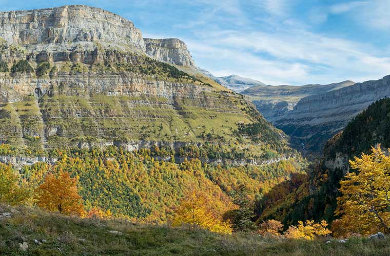
Autumn is one of the best times of the year for visit the Ordesa canyonin the Ordesa y Monte Perdido National Park. The valley is full of beech, oak, willow, maple, hazel, ash and other species that in autumn give a special colour to the landscape, combined with the rugged and rocky walls of the valley. The special colours of the forest lend themselves to contemplation. In addition, the spectacular waterfalls in these months are often fed by the rains, creating landscapes that are hard to forget.
- Cirque de Soaso and Cola de Caballo by the Pelay Girdle. REVIEW7h (return trip), Difficult, 650m ascent. RECOMMENDED TIMEFrom June to October. ACCESS. The route starts in the Ordesa meadow, which can be reached by car from Torla or by the park bus in the summer months. TRACK (Click here). This route offers one of the best panoramic views of the Ordesa Valley: the one that can be seen from the Faja de Pelay, a long terrace on the vertical wall of the Ordesa canyon. THE ROUTE. Starting from the end of the Meadow of Ordesa, we will cross the Arazas river over the bridge that crosses the Path of the Hunters. The path climbs steeply up to the viewpoint at Calcilarruego. Just before it links up with the path of the Pelay Girdlewhich hangs over the southernmost ledges of the valley. We conclude at the Soaso and Cola de Caballo circusto return along the path that descends the Ordesa Valley.
Fuentes del Narcea and Muniellos Forest (Asturias)
The more than 567 square kilometres of the Natural Park of Fuentes del NarceaDegaña and Ibias have amazing natural sites that are even more splendid in the autumn season. The incredible diversity of this place of Asturias was recognised by Unesco as a biosphere reserveThe reserve is home to capercaillies, chamois, foxes, wolves, brown bears, otters and a wide variety of birds that will delight lovers of the natural world. It includes the Integral Reserve of Muniellos and the Cueto Arbás Partial Nature Reserve. The sources of Narcea have one of the most extensive deciduous forests on the Iberian PeninsulaThe autumn colours can be enjoyed in all their splendour. A visit to the Muniellos forest is the equivalent of getting to know the largest oak grove of Spain. At the end of October, the beech and oak trees are dressed in their autumn colours, giving visitors the gift of their magnificent hues.
- Route of Muniellos and its Lagoons from Tablizas, Cangas del Narcea. REVIEW7h30′ (circular route), 18,5 km, Difficult, 1000 m ascent. RECOMMENDED TIMEAutumn is the recommended season, although any season is suitable. ACCESS. The route departs from Tablizas, from the Casa del Guarda, and follows the larger of the two possible routes that this park allows. It is necessary to obtain the permission on the website of the Principality of Asturias. TRACK (Click here). THE ROUTE. Circular route that starts near the Reception Centre, goes up the slope over the valley of the Muniellos River to the area of The Three Crosses. The path is well signposted. When we reach the Island LagoonWe can continue climbing up a steep slope to see the lagoons located at the top, Lagunas de Fonda and Grande. The descent is first through the valley of the Candanosa River and then the Muniellos to Tablizas.
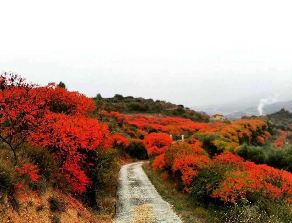
Red sea on the "Sumac Route" (Navarre)
The sumac is a shrub that was brought to the Navarrese village of Estella-Lizarra in the Middle Ages from the East. This shrub, its leaves and branches, was used in the flourishing leather tanning activity in the city. It is now a living legacy of the past and can be found, endemically, on the edges of plots of land, in "ribazos", between abandoned olive groves and vineyards. Today, in the wild, it is gaining ground over other plant species. In autumn, leaves and fruits take on a reddish colour that tints the fields and hillsides.. A nature photographer's delight.
The "La Ruta del Zumaque" trail runs along these slopes that surround the city of Estella-Lizarra, which we can cover in just over 13 km and three and a half hours (four if we opt for the "Valmayor" variant). The Zumaque is the common thread to get to know the cultural and natural history of the place. In the following link we recommend you to listen to the radio audio RTVE that will undoubtedly inspire you to set a date for your visit to this town in Navarre.
- The Sumac Route in Estella-Lizarra. REVIEW4h05′ (circular, through Valmayor), Medium difficulty, 480 m ascent. RECOMMENDED TIMEAutumn, when the sumac turns its leaves reddish and shows itself at its best. ACCESS. You will find the sign of the route in the heart of the monumental quarter, in Rua street at the height of the Puente de la Cárcel, the so-called "Picudo", this will be our starting point. TRACK (Click here). THE ROUTE. The trail leaves the city and returns to it on 3 occasions, so there is the possibility of designing a tailor-made itinerary or choosing the most interesting sectors. The first sector corresponds to the area of San Lorenzo and San MillánThe route is 5km of sunny slopes where we will have the opportunity to reach the highest point of the route. In autumn the variant called "Valmayor will allow us to walk among wild sumacs and immerse ourselves in their reddish tones. We recommend that you walk these 3.5km along the old Camino a Grocin. The second sector is 4.5km that runs through orchards and climbs up to the pine forests of Santa Barbara. Along the path of the milk churns we will reach the Ermita where we will have another of the panoramic views of the city; there, if we look carefully, we will find the remains of an old Carlist Military Fort. We will continue through pine woods and reach the area of La Chantona. The third, despite being the shortest, climbs steeply in just a few metres up to the Cross of the Castles from where we will have unbeatable views of the city and the monumental quarter. We will return to the Puente de la Cárcel point where we can enter the historic district of San Pedro and the Curtidores district. After the route, as good hikers, you will be able to take a local craft beer which has sumac, a species derived from this shrub, widely used in the gastronomy of the Middle East and the Mediterranean Basin. All you have to do is ask for a "Rhus (Latin for sumac) in any bar in town.
Fraga del Eume (A Coruña)
The Fragas do Eume is one of the best-preserved Atlantic riparian forests in the European region. This forest follows the course of the river Eume and is particularly suitable for those in search of solitude and humidity: on its more than 9,000 hectares, only a little more than 500 people live there.
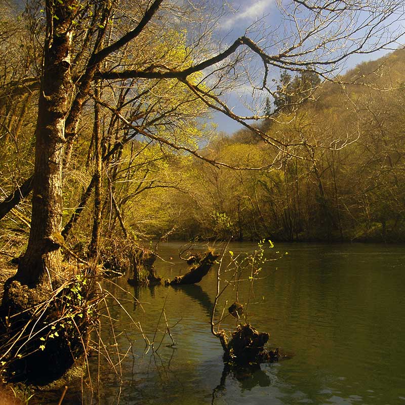
In its trailsIn the park, visitors can contemplate the more than 20 species of ferns and more than 200 species of lichen that live there, together with oak, ash, poplar and alder trees of dazzling colours.
In addition, in the heart of the forest lies the ancient monastery of CaaveiroThe monastery is more than ten centuries old. Since 1975, this monastery has been declared a Historic-Artistic Monument: its oldest remains date back to the 12th century.
- Route Camino dos Encomendeiros - Fragas Do Eume. REVIEW4h30′, 14,8km (circular route), Medium difficulty, 370m ascent. RECOMMENDED TIMEAny time of the year is recommended, but autumn is undoubtedly the most spectacular. ACCESS. Cal Grande Bridge (Eume River), Fragas do Eume, Pontedeume (A Coruña). TRACK (Click here). An essential route in the Fragas do Eume park, which will take us to the monastery of Caaveiro along the banks of the river Eume. THE ROUTE. This is a circular path. The first suspension bridge is Cal Grande. A detour to the left takes us to the Sesín river, which we cross to continue upstream. The old mill and the great medieval bridge of Caaveiro, a cobbled road leads us to the Monastery of San Juan de Caaveiro. Now the cobbled road takes us to the bridge of Santa Cristina, we cross it and continue along the edge of the river Eume on asphalt until we reach the suspension bridge of Fornelos, which we also cross. We now continue along a non-asphalted road to the starting point.
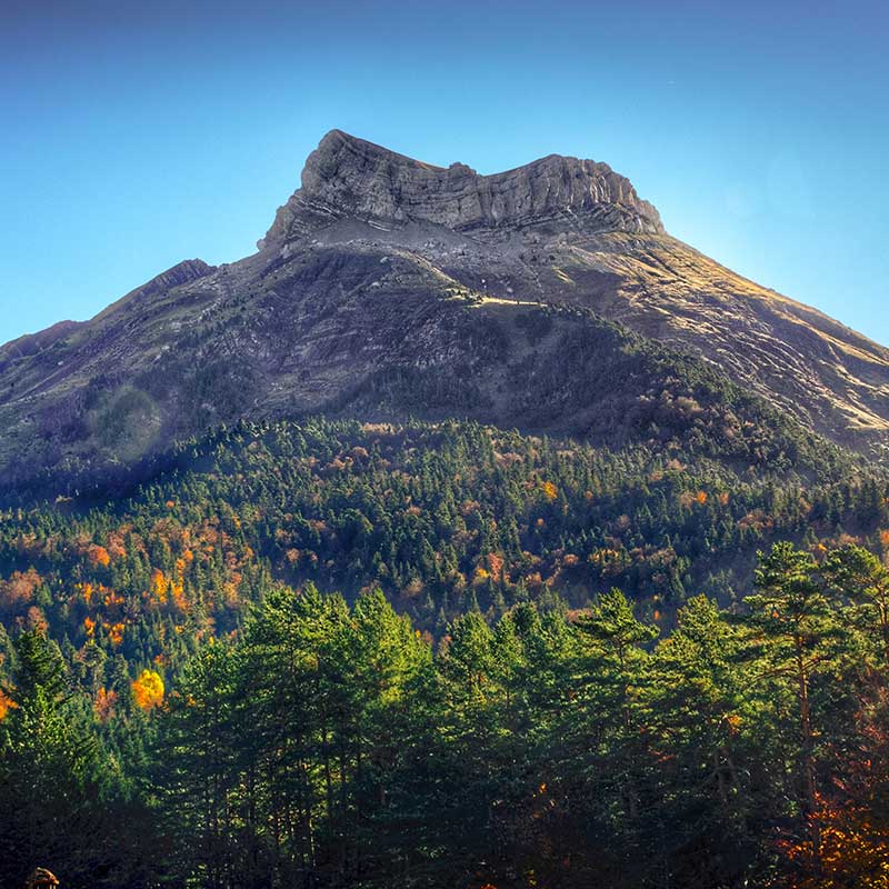
Moncayo Natural Park (Zaragoza)
The Moncayo Natural Park is one of the protected Natural Spaces of Aragon. The Moncayo massif is located in the west of the province of Zaragoza. Its wooded landscapes are ideal for the enjoyment of the hikingThe slopes of the massif are covered by well-marked trails.
This massif has two well-differentiated slopes: the northern one is colder and wetter and the southern one is full of caves, crags and ravines. Strolling along the paths on the north face is the equivalent of finding oak, pine and beech forests, while the south face, although less well known, has a varied fauna.
- Peña Roya beech forest, Moncayo. REVIEW2h20′; 7,8km (circular route), Low difficulty, 270m ascent. RECOMMENDED TIMEAutumn, although the forest maintains its splendour in all seasons. ACCESS. The route starts at the Fuente del Sacristán. TRACK (Click here). A beautiful route that takes us into this colourful forest and shows us the great variety of landscapes on the northern slopes of the Moncayo. THE ROUTE. From the Fuente del Sacristán (car park) we follow the GR-90 signs, the path crosses the beech forest as it ascends slightly. To reach the Prado de Santa Lucía the path shortens the zigzags of the road, which we cross several times. At this point we come across an old snow well and the ruins of the Hermitage of Santa Lucía. Following the signs we turn right and for about 1 km we stay on the road and then continue to the right (signpost). After a gentle descent through the forest and along a forest track we arrive back at the starting point.
Forests of Saja (Cantabria)
The thick forests of the Saja in Cantabria are one of the largest forest masses in the Cantabrian Mountains. A quarter of the park is covered with beech and oakThe forest is covered with three types of oak, chestnut, hazel, ash, maple and honeysuckle trees. As the altitude of the forest rises, the beechThe beech trees, which shelter anemones and orchids in their shade. At 1,300 metres, the beech trees give way to the holly and birch trees. An impressive flora to observe in all its autumnal splendour.
- "Sendero de Rozas" or "Ruta de los Puentes" (PR-S 111). REVIEW: 5h05′, 18km (circular route), Medium difficulty, 320m ascent. RECOMMENDED TIMEAutumn, although it is also a highly recommended route for the rest of the year. ACCESSStarting point: Casa del Monte in the Ucieda countryside. TRACK (Click here). Circular route through the Saja-Besaya Natural Park. THE ROUTE. From the Casa del Monte we take the track that takes us to El Moral, where we will find signs for the PR path. We pass a hut and take the path on the left to enter the forest. In Bujilices you will find unique trees such as the "roble tumbado". Before reaching the Jou de la Collá hut, a shepherds' hut, we will go into small woods, and so we reach the Rozas settlement, with the remains of houses and farm boundary walls. We go back to continue along the path of Monte de las Palancas, returning to the starting point.
Redes Mountains (Asturias)
Located in the Principality of Asturias, the 38,000 hectares of the Redes Park have an important wealth of landscapes and contrasts: glacial formations such as cirques and karst shapes coexist in their spaces, together with mountains and wide fields. And when it comes to vegetation, 40% of its territory is covered with trees.
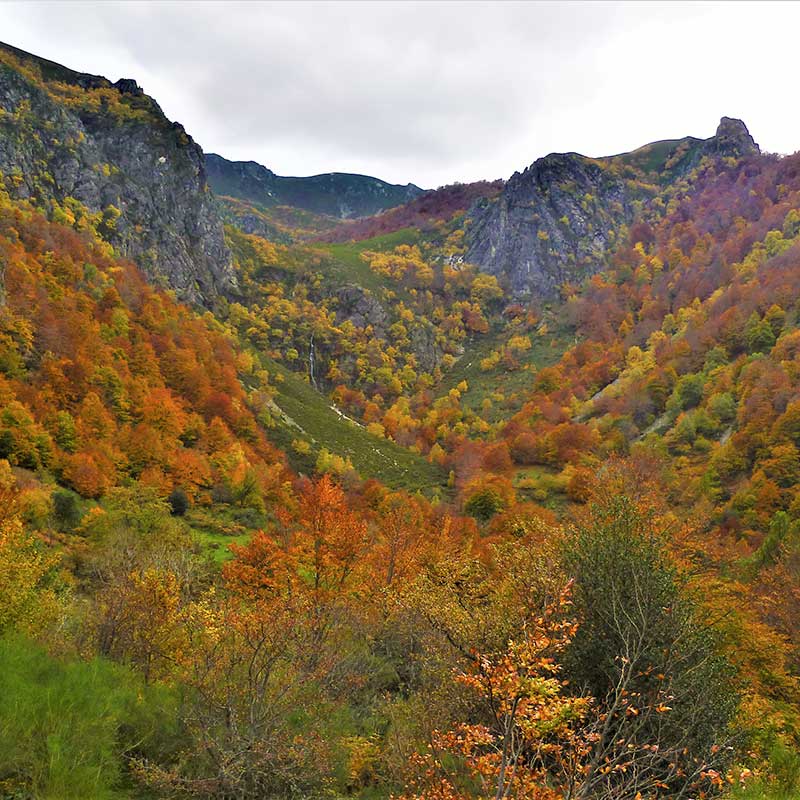
The striking peaks, open valleys and limestone gorges The Redes mountains come to amaze visitors: brown bears, wolves, capercaillies, chamois and Asturian deer also live there. In the Redes mountains there is an abundance of beech forests, dotted with oak, ash, birch, yew and holly trees. In the high mountains there are thickets of creeping juniper, heather and blueberries.
- Castañeru Route, in the Redes Mountains. REVIEW2h05′, 5,3km (circular route), Low difficulty, 220m ascent. RECOMMENDED TIMEAutumn, of course, although it will also embrace you at other times. ACCESS. The route starts in the town of Rioseco. TRACK (Click here). The route is signposted, although at several points you have to be careful not to stray. THE ROUTE. The road that leads to Soto de Agües, crosses the reservoir and turns off to the left towards El Llosu. We now take the track on the right that climbs gently between chestnut trees and leads us to the meadows of La Trepe. Along a cart track we reach the spring of El Focarón and the meadows of La Cruz, enclosed by wooden fences. A little further up in the fields of Cueria we find some huts and stables. Beautiful views of Rioseco and the reservoir. We resume the ascent, we leave the Roces sheepfold, the stables follow one after the other. We can see the Castrín Recreational Area. Once again the panoramic view makes us stop, the silhouette of the Cuyargayos peak is silhouetted on the horizon. The track enters the Castañeru Montes to return to the starting point.
Irati Forest (Navarre)
From Roncesvalles to Belagua extends the Irati Forest. In its grounds, hundred-year-old beech trees mingle with black pines and firs in the mist that is characteristic of the area. The grove is crossed by two trails which were laid out on the path of the ancient shepherds and the traffic of the locals. Autumn is the perfect time to enjoy this area of Navarre.
- Circular route in the Irati Forest: Akerreria and Malgorra from the Houses of Irati. REVIEW6h00′, 15,3km (circular route), Difficulty high due to the confusing nature of some areas, 970m ascent. RECOMMENDED TIMEIn winter the high areas will be less accessible, in autumn the magic of the Irati Forest unfolds. ACCESS: Car park below Casas de Irati / Virgen de las Nieve. TRACK (Click here). THE ROUTE. Circular route through the interior of the Irati Forest in which we will ascend Mount Akerreria (1,317m), Logibeltza (1,287m), Baltsazarras (1,298m) and Malgorra (1,363m). From Casas de Irati we will go up the Camino Viejo a Casas de Irati (SL-NA 60A) until we reach the Akerreria pass, where we will leave the local path to go to the Akerreria mountain. From the summit of Akerreria, the route continues along the ridge, gaining or going around Logibeltza and Baltsazarras, if you prefer, to then enter a confusing area with several peaks of similar altitude. Malgorra, the highest of them all, is broken to the south. Once the summit is reached, the route descends to cross the Malgorra stream to go down along a path to the Koixta reservoir. From here, along a track for approximately 1 kilometre and then along the old road to Koixta, we return to the start of this excursion at the Casas de Irati.
Selva de Oza (Huesca)
The highlands of the Aragonese valley of Fact are crowned by an old forest of beech and fir trees, where the black pine paints its ridge. The twisted gorge of the Hellmouth The Aragón Subordán river rises up to its sources, where the mountains enclose this Pyrenean forest saved from the axes by its inaccessible location.
- Route to the Selva de Oza along the Roman road and the old Oza path and return along the Los Ganchos path. REVIEW5h17′, 13,8km (circular route), Medium difficulty, 856m ascent. RECOMMENDED TIMEAlthough the route runs through the valley, it does not go into the peaks, and this area is not very accessible to the general public in winter. Autumn here is spectacular. ACCESS. Turn off the road towards the bridge of Santa Ana and Gabardito. TRACK (Click here). THE ROUTE. We ascend towards Selva de Oza along the old Roman road, on the right bank of the Aragón Subordan river (GR 11 markings). We descend to the course of the river to cross it and gain height to cross rocky outcrops. Once we have crossed the Espata ravine we return to the river in Selva de Oza. Now it is our turn to return, initially following the road south to the San Juan de Dios campsite where we cross the river again over a footbridge to take the Camino de los Ganchos. The route gains altitude and heads south. Finally it comes out onto the lower slopes of the south face of Peña Agüerri to descend to the ravine. We now cross a metal footbridge and take the track that will take us back to the Santa Ana bridge, our starting point.
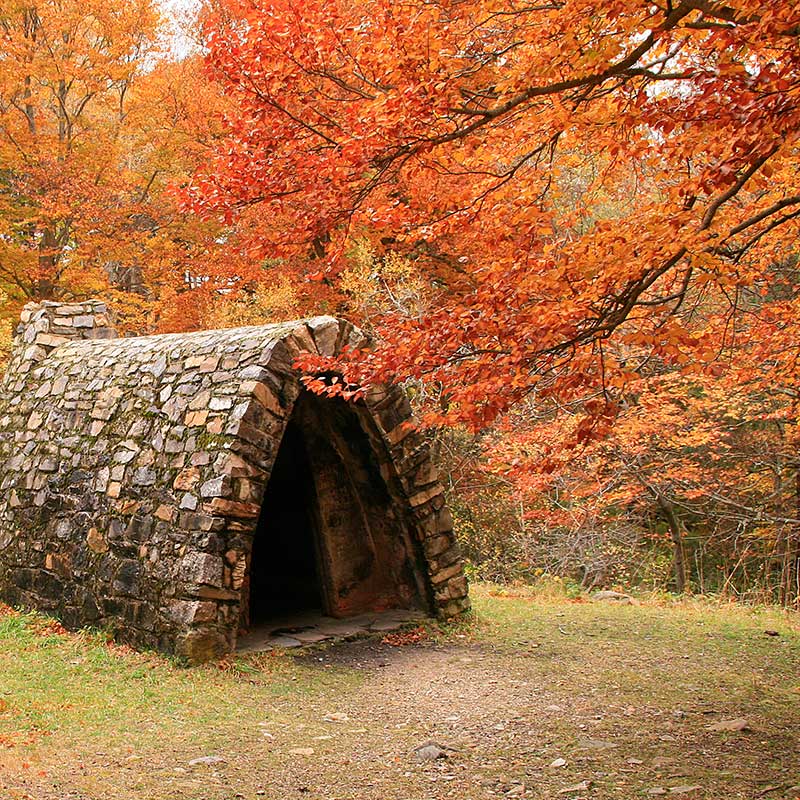
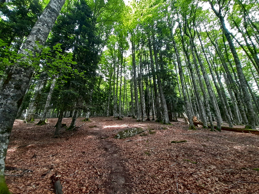
Tejera Negra (Guadalajara)
The autumn colours the mountains of the massif of Ayllonstraddling between Segovia y Guadalajarawhere there is a beech forest (in the picture) which was named after its yew trees. A relict beech forest dotted with dark yew treeswhich has survived the passage of time in latitudes where it should have no place.
- Tejera Negra beech forest: Senda del Robledal (oak grove path) and the Carretas. RECOMMENDED TIME: Spring is usually very busy, autumn is a nice time of the year. ACCESS. Park Interpretation Centre (2.5 km from Cantalojas). TRACK (Robledal Path / Path of the Carts). THE ROUTES. There are two circular routes, signposted and with interpretative panels: the Senda de Carretas (6 km) and the Senda del Robledal (17 km, with the possibility of linking them and continuing along the Senda de Carretas). The Senda de Carretas (3 hours) is a very gentle route and is accessible to the general public, even for families with children. We will discover spectacular corners of the beech forest. The Senda del Robledal (5 hours) is a longer, more difficult route.
Iregua Valley and the Sierra Cebollera (La Rioja)
La Rioja Media is home to a special valley that owes its name to the Iregua River: this is born in the Sierra Cebollera and flows through the whole valley until it flows out near Logroño. Precisely in the Sierra Cebollera is located the Natural Park of Sierra CebolleraLa Rioja's only natural park. The beech forests of this beautiful valley are the last of the native rainforests of La Rioja. It is worth noting that the beautiful landscapes allow visitors to enjoy the hiking trails and walks.
- Path of the Puente Ra waterfalls. REVIEW. Circular path with a link to the Cascadas and back. 6,6 km, 2h00′, Low difficulty. RECOMMENDED TIME: Autumn. ACCESS. Car park at the Ermita de la Virgen de Lomos de Orios (1,400 m), which can be reached by car on the road from Villoslada de Cameros to the Ermita (9 km). TRACK (Click here). THE ROUTE. Excursion of the Lomos de Orios Hermitage to the waterfalls and cascades of the Arroyo de Puente Ra. From the car park there is a forest track leading to the Majada de las Desecadas (stone corrals). At this point the path descends through pine woods to the path of the Ra Bridge Stream. The path to the waterfalls climbs parallel to the stream. We arrive at the waterfalls. We return by the same route. The route reaches the Ra BridgeBefore crossing the bridge, we climb up to the right over varied and rocky terrain to reach the hermitage again.
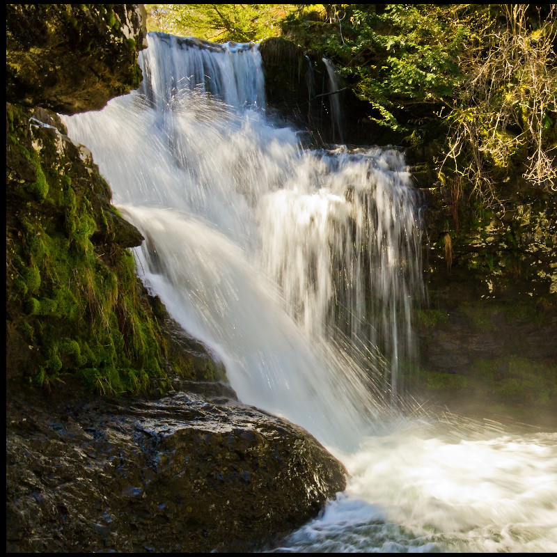
Monte de Santiago and the Salto del Nervión (Burgos and Álava)
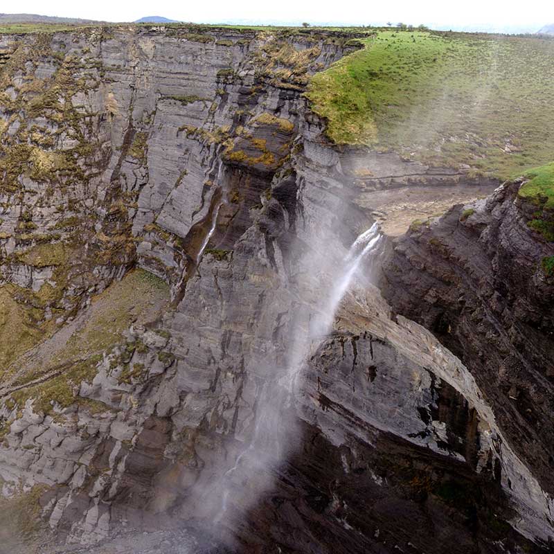
The Mount Santiago at Burgos the beech forest of Santiago: among its fronds, hides the source of the river Nervión. Further on, the river Nervión falls from the Sierra Salvada. This waterfall, called Nervión waterfallIt is considered to be the highest waterfall in Spain: it is an impressive spectacle to contemplate the 222-metre waterfall.
- Walk along the Salto del Nervión path (Monte Santiago). REVIEWCircular route, 1h20′, low difficulty, 125m gradient, 6,4km. RECOMMENDED TIME: Autumn. ACCESS. From the village of Orduña, we climb up to the Orduña pass. At the top we will see the first of the 3 car parks where we can park. TRACK (Click here). THE ROUTE. From the car park we first go to the Esquina de Rubén viewpoint, where we turn left to begin the gentle ascent to the viewpoint through a beautiful beech forest. Descend towards the Salto del Nervión, walking parallel to the cliff along a narrow path. Natural viewpoint. Further on we see a wolf trap, to finally reach the viewpoint of the waterfall. We return along a wide and comfortable path without getting lost until we reach the car park where we started. 100 m before arriving we see on the right the ruins of the monastery of Santiago de Langrériz and on the left the house of the Monte Santiago Park.
Fastpacking is not about going faster. It's about going lighter.
If you come from classic trekking, this is the next step: learning to move with less weight,
more fluid and enjoying every kilometre more.
Join the Outsiders Newsletter and start discovering what lightness feels like.