GR54 : Tour de l'Oisans and the Écrins
Pyrenees and mountains 📩
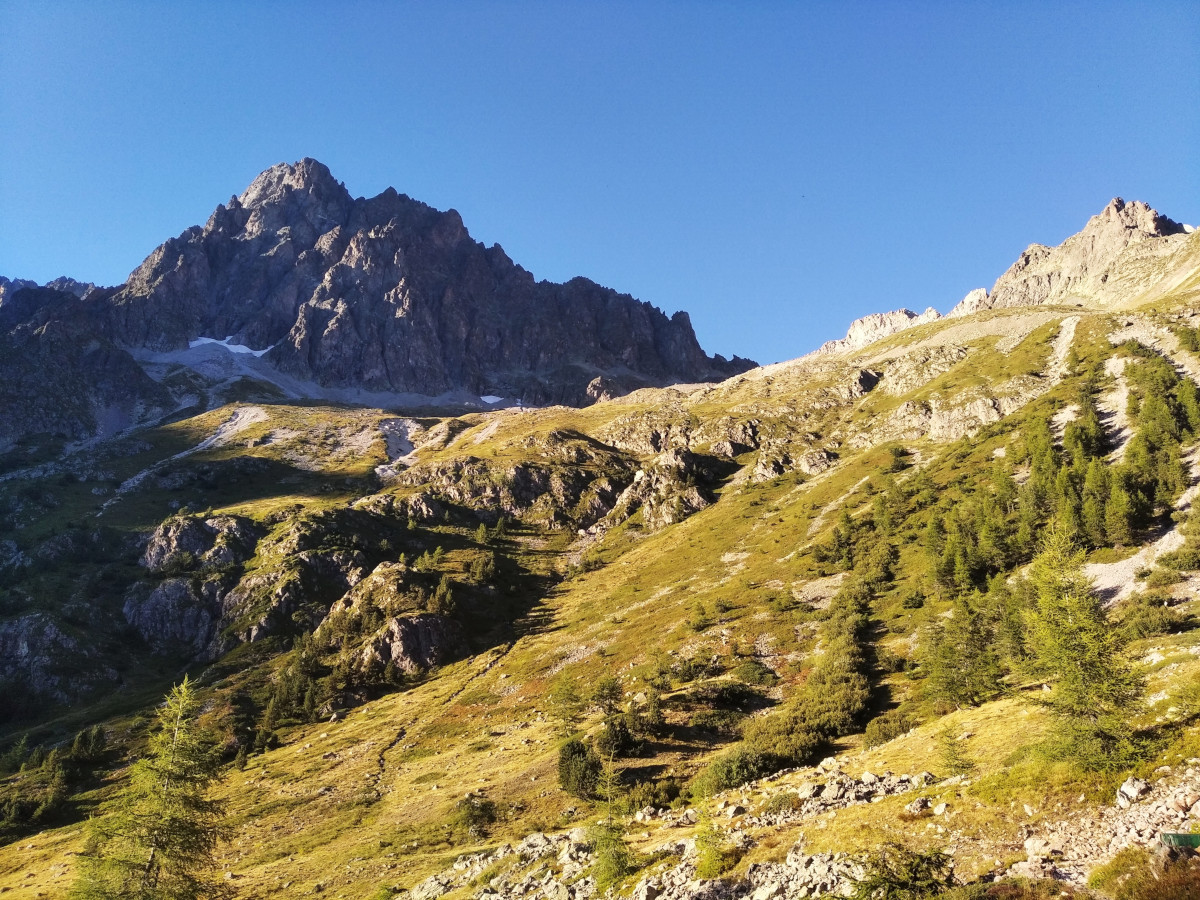
Here 🔥The GR 54 is one of the main hiking routes in the French Alps, along with the Tour du GR 54. Mont Blanc and the Vanoiseis part of the trilogy. A route of 176 kilometres, 14 mountain passes and 12,830 m of elevation gain. It takes place in the heart of the Écrins National Park, with great peaks such as the Meije of 3983 metres, the Barre des Écrins of 4102 metres and many more. A trek through alpine villages, deep valleys and high mountain passes, guarded by a wild environment. The scenery encountered on the Tour des Oisans is spectacular and always varied, which, with charming villages and hamlets to visit en route, makes for a rich and rewarding hiking experience.
- SHORTCUT: Jump directly to the practical guide (Click here)
The Tour of the Oisans covers a distance of 176 km, crosses 14 passes and climbs a total of 12,830 m in 10 to 13 days.. Several stages of the Oisans trek cross unprotected rocky sections, or follow narrow, exposed paths protected by a fixed cable. Others run across steep shale and sand slopes and some of the cols are so narrow that you could straddle the ridge with your legs dangling over the side.
The Tour of the Oisans is tougher and more demanding than most other multi-day tours in Europe.Although this is a trek that does not require technical mountaineering skills, it does require climbing ability and confidence to manage at altitude. The Alpine Massif is one of the most challenging alpine environments, and no one should take on the challenge of this route lightly.
A bit of history
The creation of the route was the dream of Roger Canca humble guide and writer. At that time there was already a tour of Mont-Blanc and it was then that he decided to create the tour of the Écrins. Throughout the winter of 1962 the guide and some friends created and marked the route with whatever they had at hand. In addition to this, they designed a map of the route by hand. After contacting people in the surrounding valleys they were able to offer shelter and other services. In 1964 the route was officially named GR 54 and 10 years later what is now known as the Écrins National Park was opened.
Practical guide
/ When to go? / Difficulty and tips / Team / Cities & Services / Stages /
When to go?
It is generally recommended to do this experience between mid-July and mid-September. Avoid before mid-July (snow on higher passes). Accommodation busiest mid-July to late August. September is ideal and October can be good, although some accommodation closes in October.
It is important to study the weather conditions before going and to observe the impact of snow on the mountain. Some passages near the high mountain are in difficult and risky terrain.
Difficulty and tips
Duro..... perhaps one of the toughest hikes in Europe. High, steep and remote in places. No technical mountaineering skills are required, although you will find some exposed sections unprotected.
Equipment
A good backpack, comfortable and waterproof footwear, an appropriate sleeping bag, a first aid kit, clothing suitable for different climates, a specific map of the area, and much more. We recommend you take a look at our guide: What to pack in your basic trekking kit.
Cities & Services
The two best-known or most frequented points of departure are the Burg d'Oisasns and the l'Argentiére - la - Bessée. The description of stages which we present to you, starts and ends in Bourg d'Oisins, passing through La Grave, Vallouise and La Chapelle-en-Valgaudemar.
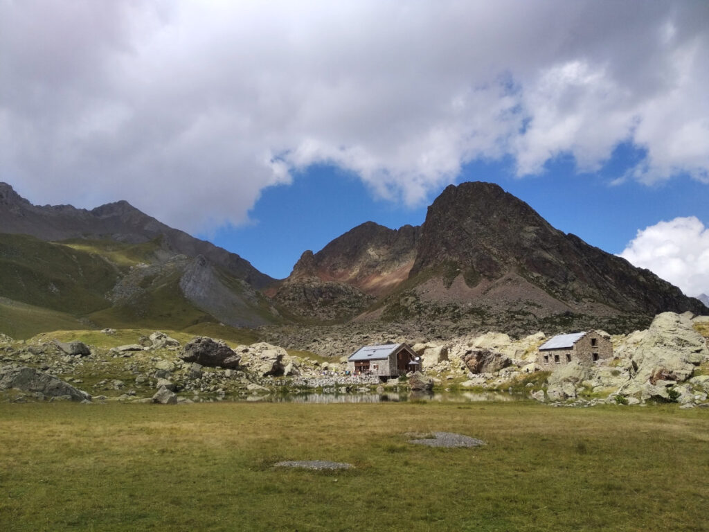
Another thing to consider is accommodation. Open-air camping is possible all along the Écrins route.It is advisable to check the national park regulations for updates and warnings. All along the route you will find campsites, refuges, hostels and other services. As for food, there are some stages where you will have to plan your supplies and food en route.
The stages
A trail with multiple possibilities, we can highlight two alternatives:
GR 54 from Bourg d'Oisans: Following in the footsteps of the pioneers of the Écrins, visiting the most isolated mountain pastures, the high glacial lakes and the mountain stream of Onde.
The route follows the GR54 around the Écrins clockwise over 10 long days and includes some alternative sections to consider.
- Stage 1 Bourg d'Oisans - Besse-en-Oisans
- Stage 2 Besse-en-Oisans - La Grave
- Stage 3 La Grave - Monêtier-les-Bains
- Stage 4 Monêtier-les-Bains - Vallouise
- Stage 5 Vallouise - Refuge du Pré de la Chaumette
- Stage 6 Refuge du Pré de la Chaumette - La Chapelle-en-Valgaudemar
- /Alternative Stage 6/ Refuge du Pré de la Chaumette - La Chapelle by Vallon d'Isola
- Stage 7 La Chapelle-en-Valgaudemar - Le Désert-en-Valjouffrey
- Stage 8 Le Désert-en-Valjouffrey - Valsenestre
- Stage 9 Valsenestre -Refuge de la Muzelle
- /Alternative stage 9/ Valsenestre - Bourg d'Arud
- Stage 10 Refuge de la Muzelle - Bourg d'Oisans
- /Stage 10 alternative/ Bourg d'Arud - Bourg d'Oisans
- GR 54 de la Argentière-la-BesséeTwo days longer than the GR 54 from Le Bourg d'Oisans, this trail starts gently along the Onde mountain stream, up to the foot of La Pousterle pass. It joins the GR 54 at the starting point of Le Bourg d'Oisans, via the Pas de la Cavale and towards the untamed Champsaur. On the way back, the paths separate again at Vallouise. The last stage is gentler and arrives, after the pass of La Pousterle, which we left two weeks earlier, at L'Argentière-les-Écrins.
Fastpacking is not about going faster. It's about going lighter.
If you come from classic trekking, this is the next step: learning to move with less weight,
more fluid and enjoying every kilometre more.
Join the Outsiders Newsletter and start discovering what lightness feels like.