Pic de Neouvielle (3,091m). Circular route.
Pyrenees and mountains 📩
Here 🔥Circular route. To go up, follow the normal ascent route from Aubert lake. For the descent, we take a detour to the Hourquette d'Aubert and then follow a well-marked path back to the starting point.

- Distance:
- Unevenness:
- Timetable:
- Water: There are not many places to get water. At the end of the block crossing there is a waterfall. Carry at least 1.5 litres per person.
- Difficulty: This is one of the most accessible three-thousanders, the reason being an approach by car to the Lac d'Aubert (2,150m) and the absence of a committed climbing pass. In any case, don't climb this ascent, it is a three-thousander. You will have to know how to find your way around the route, move over a terrain of boulders which makes it very difficult to move forward, overcome a snowy ramp which may require ice axe and crampons (this was not the case in August 2019) and overcome some rocky sections where you will have to use your hands. As for the weather, please be aware of the warnings and especially the risk of thunderstorms.
Tour
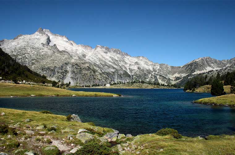
- () Aubert Lake (). Cross the dam and ascend through grassy terrain, along the path that climbs straight ahead in a southerly direction. After a few minutes we pass the crossroads that leads to the Cap de Long reservoir via the Pas du Gat and turn right (West). We advance carefully following the milestones in search of the best pass to flank the Barris ridge that comes down from Ramougn (3,011m).
- () Barris Gap (). On the other side of the ridge, the path becomes blurred and we follow the milestones amidst a chaos of blocks that prevent us from going any faster. We advance with our sights set on the Chausenque gap until at last the valley that we will follow towards the summit is revealed on the left. The snow soon appears, a relic of a glacial past. The end of the snowfields is interrupted by a rocky strip that we cross and from here we head off to the left. At the top we can see the gap towards which we are heading. We overcome a couple of passages using our hands (without exposure) and come out onto the east slope of the peak, which is very steep. Carefully make a short traverse until you reach the channel that leads to the summit.
- () Neouvielle (3,091m). We descend along the same route to the end of the persistent snowdrift.
- () Alternative return (). This alternative makes for a very long and heavy traverse between large boulders that we only recommend if you are very keen to do a circular route. We will be guided by the milestones which, on the other hand, appear everywhere. The positive side are the fabulous views over the Neouvielle and that at least the descent once we are at the Hourquette d'Aubert will be quick.
- () Hourquette d'Aubert (). The path is still stony, but at least now we are advancing quickly. Little by little the first pine trees start to appear and the green becomes the protagonist. We leave the lake of Aumar to the left and we face the last stretch of the descent to the busy
- () Lake Aubert ().
How to get there
From Spain, cross the Bielsa-Aragnouet tunnel on the A-138. Once in Fabian, 10 kilometres from the mouth of the tunnel, turn left onto the narrow road signposted "Reserve naturelle du Neouvielle", "lac de Cap de Long" and "lac d'Oredon". After 10 kilometres you will come to a crossroads, on the left you will go up to the Cap de Long, on the right you will go to the lake of Oredon. The entrance to the nature reserve is restricted to vehicles. It costs 9€ to leave your car in the car park at Lac d'Oredon for 24 hours. To get to Lake Aubert, you can take the bus or drive up between 7pm and 9am. After that, a second barrier prevents access to Lake Aubert.
Practical information
Please note that you are in a National Park and there are some restrictions. The most important ones:
- Vehicle access during the summer months is restricted from Oredon Lake onwards. It is closed between 9.30 am and 6 pm. There is a paying car park next to the lake (€9 per 24h). To go up to Lake Aubert in a private vehicle, you can do so outside these hours and if you go down later there is no charge. Within the timetable there are frequent buses (30min).
- It is forbidden to sleep inside motorhomes, vans and cars within the park boundaries. You can do so just outside. The prohibition starts at the Oredon lake barrier. You can also sleep in the chalet-shelter of Oredon or pitch your tent in either of the two authorised areas (by the lake of Oredon and by the lake of Aubert).
- Dogs are not welcome. They are forbidden even on a leash.
For more information on of the regulation by clicking here.
The Neouvielle "
The Neouvielle massif, Nature reserve since 1936, integrated into the eastern end of the Pyrenees National Park It is one of the most beautiful granite massifs in the whole of the Pyrenees. Its interior is home to a myriad of lakes and extremely jagged peaks (19 of them above 3,000m) from which endless granite ridges jut out. A few glacial relics remain, the most significant of which is the Pays Bache glacier on the Pic Long. Those that used to surround the Neouvielle (in Occitan old snow) are today only permanent snowfields that no longer live up to their name.
The king of the massif is the Pic Long de Neouvielle (3,192m), the most difficult of the 11 three-thousanders with the honour of being the highest point of a massif, which means that it is not very popular. Alongside this, the list of the 19 three-thousanders of the massif is made up of two large groups. Around Pic Long, on the north ridge, Pic Maubic (3,058m) and Aiguille Tourrat (3,014m), on the west ridge, Dent d'Estibère Male (3,017m), Pic de Bugarret (3,031m) and Pale de Crabanousse (3,021m) and on the south ridge, Aiguille Badet (3,135m), Pic Badet (3,160m) and Pic Maou (3,074m). Close to this sector but somewhat separated are Pic Lentilla (3,157m), Campbieil (3,173m) and Pic d'Estaragne (3,006m). The other large group of three-thousanders is concentrated around the Pic de Neouvielle (3,091m). Next to it is the Pointe de Ramougn (3,011m). Following the ridge to the south we find the rest, the Pic des Trois Conseillers (3,039m), the Premier Conseillers (3,035m), the Turon de Néouvielle (3,035m) and the Pointe Reboul Vidal (3,007m).
The Pic de Neouvielle (3,091m), without being the highest, is the most visible of the massif's three peaks. Its rugged silhouette with an impregnable appearance, visible from the lakes of Aumar and Aubert, together with the sharp Ramougn peak (3,011m) just in front of it, are the most recognisable symbol of the massif. The beauty of this peak, together with the low difficulty of the route, make it the most visited of the massif's three peaks. Highly recommended as an introduction to the Pyrenean three-thousanders.
Books and maps
The book of Sua's three-thousanders, the map of randonees...


Fastpacking is not about going faster. It's about going lighter.
If you come from classic trekking, this is the next step: learning to move with less weight,
more fluid and enjoying every kilometre more.
Join the Outsiders Newsletter and start discovering what lightness feels like.