La Porta del Cel, a route that will take you to the highest peak in Catalonia
Pyrenees and mountains 📩
Here 🔥
Quick guide TREKKING SEVERAL DAYS in the Pyrenees
with everything you need to know before undertaking a multi-stage circular route.
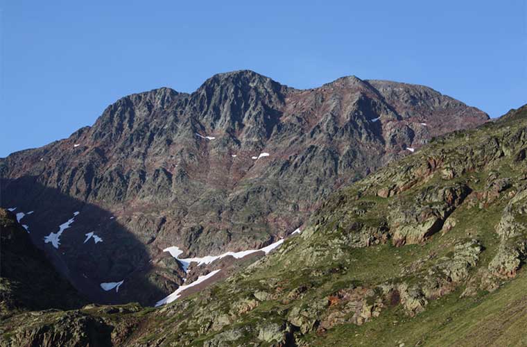
Trekking the trekking route La Porta del Cel is equivalent to climbing the highest peak in Catalonia, the Pica d'Estats. This 3,143-metre-high mountain, located on the border between Spain and France, is also one of the highest in the Pyrenees. And not only that, as the route of La Porta del Cel also includes the Certascan peak, at 2853 metres, and the Cigalera Rock, at 2668 metres, making the scenery truly breathtaking.
The complete circuit of La Porta del Cel links the refuges of Certascan, Pinet, Vallferrera and the village of Tavascan. The route runs between the Catalan Pyrenees and the French Pyrenees and enters the Alt Pirineu Natural Park.
You may be interested in: Discover the most emblematic circular hiking routes in the Pyrenees>>>>.
La Porta del Cel
The Porta de Cel route is a classic Pyrenean route. The proposal is to do it in five stages, through which you will not only climb the peaks of Pica d'Estats, Certascan and Roca Cigalera, but you will also visit a number of glacial lakes along the way.
Among these lakes, the Certascan lake stands out. This impressive water reservoir, also of glacial origin and crowned by the Certascan peak, has a depth of almost one hundred metres. It is the largest lake in the Catalan Pyrenees and the Certascan refuge is located nearby.

What is recommended for those wishing to do this demanding route is that they should be in good physical condition and be used to hiking for several days. The total length of the route is estimated at 64 kilometres, with a cumulative difference in altitude of 5,500 metres, over fairly steep mountain terrain. However, the beauty of the scenery will make it well worth the effort.
The Porta del Cel route
The proposal is to do five stages, covering a daily average of thirteen kilometres, with an average daily difference in altitude of just over 1,100 metres. The best time of the year to do this trekking route is between the months of July and October.
The La Porta de Cel route lasts a total of five days and four nights. One of the nights will be spent camping, while the remaining three will be spent in high mountain refuges, two of which are located on the Catalan side of the Pyrenees and the third on the French side.
Day 1
The first day will be relatively "gentle". The starting point of the Porta del Cel route will be Tavascan, at 1,116 metres, up to the Graus campsite, at 1,360 metres. The distance to be covered on this first day will be 4.2 kilometres, with a difference in altitude of 290 metres and an estimated time of three hours.
This day's route goes through Tavascan, a pretty village with stone houses with typical slate roofs. On leaving the village, you follow an old path along the Tavascan river, crossing an area of meadows until you reach the Graus campsite.
Day 2
From the Graus campsite, the goal is to reach the Certascan peak, located at an altitude of 2,240 metres. Here the distance to be covered is around 12.5 kilometres, while the difference in altitude will be around 1,500 metres uphill and 620 metres downhill. It is estimated that the activity will take about ten hours. The overnight stay will be in the Certascan refuge, located at an altitude of 2,240 metres.
This is the day to enjoy the breathtaking views of Certascan Lake. Although other beautiful lakes can be seen along the route, this one is particularly impressive due to its size.
Leaving the campsite, you will find yourself in a deciduous forest until you reach Noarre. Once in Noarre, you will continue the ascent, passing through the Guerossos hole, on a hard path that climbs up to the Pleta de Guerossos.
Once there, follow the river to the right, passing very close to the Blue del Medio pond. The route continues to separate from the lakes to reach the ridge and the Certascan peak. One option, if you are very tired, would be to go straight to the refuge and skip the climb to the peak. To get to the Certascan refuge we flank the Certascan lake.
Day 3
For this third day of trekking, starting from the Certascan hut, it is planned to reach the Pinet hut, at an altitude of 2,240 metres on the French side of the Pyrenees. The distance to be covered will be 13.3 kilometres and the difference in altitude is estimated at 1,350 metres uphill and the same 1,350 metres downhill. The total activity of the day could take around eleven hours.
This day will be characterised by the movement through high mountain terrain with steep slopes. In many sections the roads are almost non-existent.
Leaving the refuge, you will go down to the small lake on a zigzagging route until you reach the Llurri pass. Then you will pass the Romedo ponds and follow the path of the river until you find a climb that leads to the Puerto de la Artiga.
From there, you pass through a valley of large granite blocks until you reach the wetlands. Once you cross the wetlands, go left up a ravine, then cross to the west to look for the Recós ridge.
Finally, you will have to descend a steep slope until you come out at the neck of Pico Estela. Although there is no path, you will have to descend to pass under the spur. Then the route ascends towards a kind of pass. From this point you can cross the river, holding hands. After this crossing, you will reach the Pinet refuge.
Day 4
We have now reached the fourth day of the trek. This is the day on which you will reach the imposing summit of the Pica d'Estats, at a not inconsiderable 3,143 metres above sea level. On this day you will have to cover some 13.3 kilometres, with a difference in altitude of 1,100 metres on the way up and 1,400 metres on the way down. The total time of the activity for this day will be about 10 hours and the night will be spent at the Vallferrera refuge, once again in Catalan terrain.
The itinerary that will be followed is a high mountain route, little frequented by Catalan hikers and with a markedly wild landscape, passing by a small glacier. The route involves passing the Pica d'Estats, but if you have enough time, you can also climb Montcalm, Punta Verdaguer or Sotllo.
Leaving the Pinet refuge, you go up the river, ascending steep slopes until you reach the Riufred pass. From there, there is a well-trodden path to the Pica d'Estats. The route to the Vallferrera hut will vary, depending on the chosen itinerary.
Day 5
For the fifth and last day of the trip, the plan is to start from the Vallferrera refuge and return to the starting point in Tavascan. The distance to be covered on this day will be 20.3 kilometres, which is estimated to result in a total of twelve hours of activity. The difference in altitude on this last stage will be 1,315 metres of ascent, while the descent will be 2,100 metres.
The route passes the Baborte lakes, climbs up to Roca Cigalera and follows the ridge to pass along the flanks of the Boldís mountains until finally reaching Tavascan. It is possible to shorten the route, going down to the Planes de Boavi through the Sellente valley and down the track to Tavascan, in about eight hours.
Another possibility is that after the mountains of Boldís you continue on to the village of Àreu, until you finally reach Tavascan.
Fastpacking is not about going faster. It's about going lighter.
If you come from classic trekking, this is the next step: learning to move with less weight,
more fluid and enjoying every kilometre more.
Join the Outsiders Newsletter and start discovering what lightness feels like.