St. Donatus for the breach
Pyrenees and mountains 📩
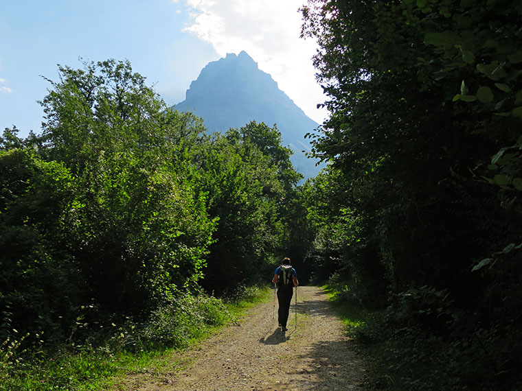
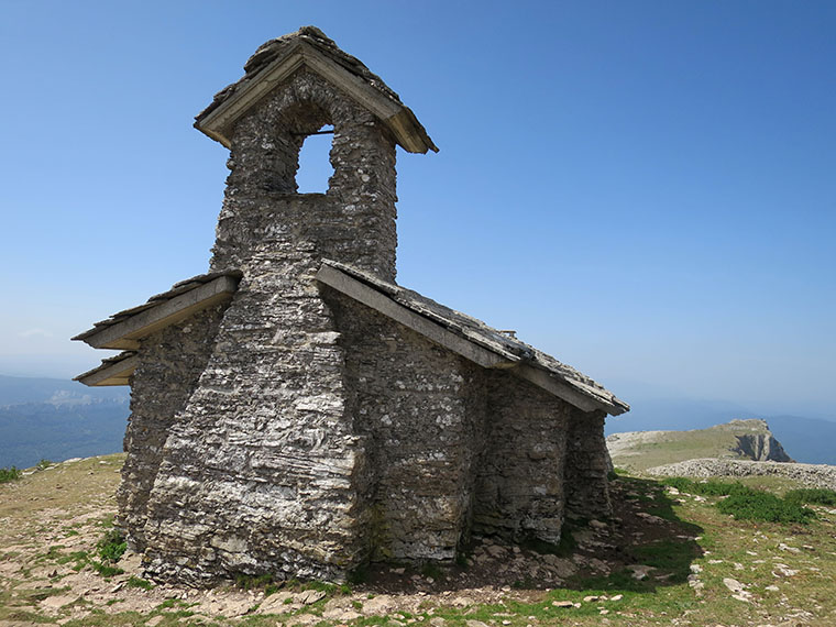
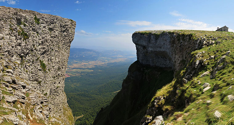
Here 🔥The mountain Beriaín (1,493m) is more popularly known by the name of San Donato due to the hermitage dedicated to San Donato and San Cayetano on the summit. It is the highest point of one of the most important mountain ranges of Navarre, that of Andía, which is part of the Urbasa-Andía Natural Park.
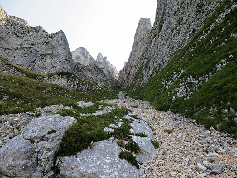
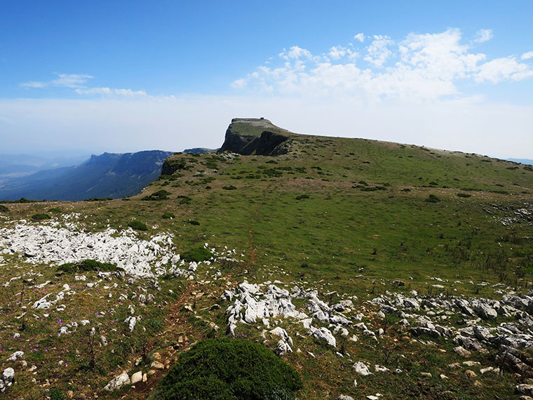
Among local mountaineers it is an emblem. Challenging in appearance, its shape has often been compared to that of a ship. To the north and south, it plunges over cliffs that drop down to valleys 1000 and 850 metres below, while the summit is a large esplanade that narrows as you move towards the "prow" (the "prow").Ihurbain; 1.420m), cut by the spectacular gap that we propose to you to cross.
Difficulty: PD Climbing. The main difficulty is overcoming several ledges up to II+, interrupted by very steep sections of corridor. The other problem is the slippery rocks even on a bright summer's day.
Material required: Although it is usually climbed without a rope, the terrain is frankly dangerous. We recommend that you take a helmet, a 30-40 metre rope and 3 or 4 maillons in case things go wrong and you have to climb out from below.
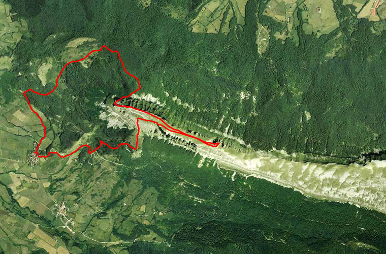
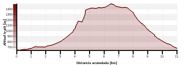
Distance/level: 11kms; 850m positive.
Time: 5 hours; walking time without stops 4h10min.
Type of route: Circular.
Maps/Bibliography: Andia Etxauri mountain range (Sua publishing house; map scale 1:25,000), Montes de Navarra (Sua publishing house), Edges and ridges of the Basque Country
(Sua Publishing House).
Route:
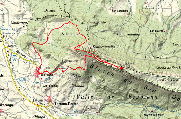
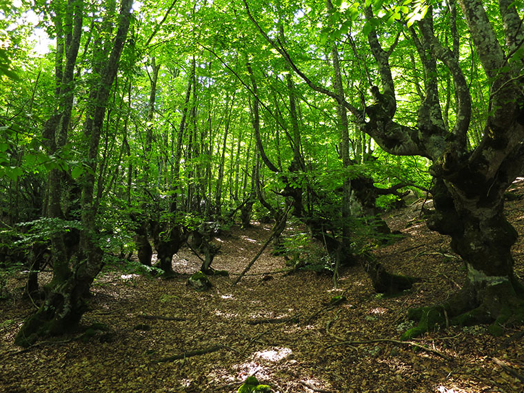
We can leave the car at the entrance of Unanua (0,0kms; 0h00min; 640m) coming from Arbizu, next to the doctor's surgery. There you will see a sign for the Senda del Pastoreo / GR282 indicating Huarte Arakil 7.0 kms. Follow the GR282 along the track that runs alongside some electricity poles in the direction of Huarte Arakil. We pass a first pass (1,2kms; 0h15min; 695m). The track runs between oaks, hazelnut trees and other bushes with our goal as a backdrop.
After a big bend to the left, 10 minutes from the pass, there is a fountain. The track then steepens again on the way to a second col (3,0kms; 0h40min; 798m) where we leave the path for good. Cross the wire fence over a wooden pass and take the path to the right. The path ascends between beeches, blackthorns, hawthorns, etc. We cross a fence and come out onto another path (twenty minutes from the pass) which we follow to the right.
Five minutes later we take a path to the right marked by milestones that climbs steadily up a rocky area. At the end of this, the path turns to the right and forks (left path). We arrive at the base of the wall (4,3kms; 1h30min; 1.170m).
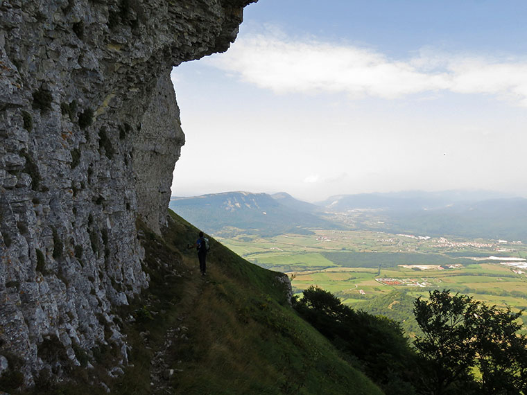
It continues along the base until it reaches the entrance to the Ihurbain gap (4,5kms; 1h40min; 1186m).
The slope is very steep but is relatively easy to climb until the start of the difficulties (15 minutes). The first obstacle is covered in grass. It is overcome on the right.
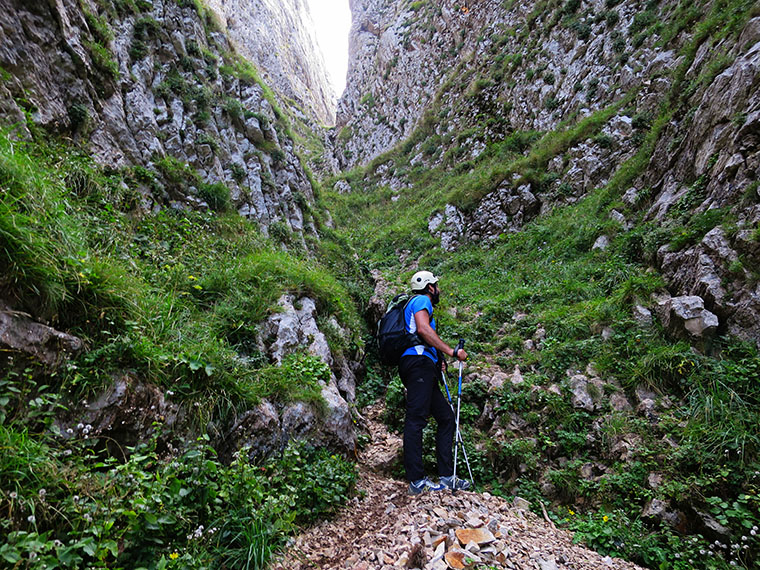
At the exit there is a parabolt. The next ledge is equipped with two parabolts at the bottom.

This is usually done via the crack on the right, although it is possible to climb straight ahead over the parabolts. There are then several sections in which we continue climbing until we reach another parabolt that marks the end of the difficulties of this section.
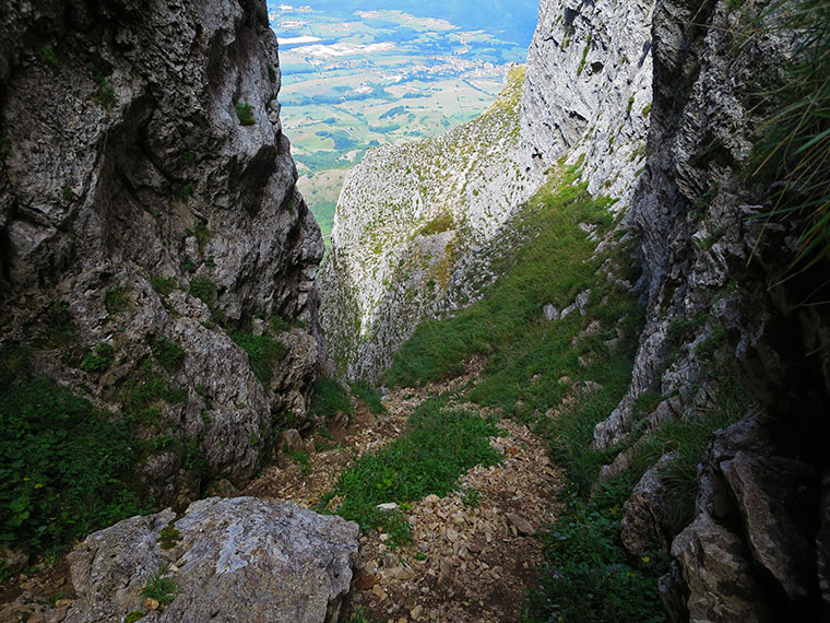

The last ledge is very short and grassy. It takes a total of 15 minutes to overcome the most difficult part of the gap. Once you have passed this last ledge, you are close to the summit. A few last metres without difficulty lead to Ihurbain. (4,8kms; 2h15min; 1.420m).
To reach the top of the sierra you still have to walk 1.5 kilometres.
At the top of Beriain (6,4kms; 2h40min; 1.493m) there is an open hermitage, dedicated to San Donato and San Cayetano, a mailbox and a geodesic vertex.
Very close to the summit, on the northern slope, is La Muela, one of the most spectacular places in the sierra.
To descend, we go back towards Ihurbain for a little more than a kilometre, watching out for a path (7,5kms; 3h00min; 1.420m) which leads off to the left, marked by large milestones. The path goes straight down, through clear terrain. When you reach the trees (8,7kms; 3h30min; 1.110m) turn right, going over rocky terrain. After passing a small clearing we cross a wire fence, we ignore a path that climbs to the left to a pointed stone (a monument to the Navarrese eight-thousander Iñaki Ochoa de Olza who died on Annapurna) and then another that descends to the right. The path descends through the forest in a westerly direction. On coming out into a clearing, the path turns left and enters the forest. Here we take the path that descends to the right down a steep slope until we reach a track and a source (9,7kms; 3h50min; 840m). Below the fountain there is a path that takes several bends to the track. Once on the track, go through a gate and take a new shortcut that descends to the left to the right. Unanua (11.0 kms; 4h10min; 650m).
Fastpacking is not about going faster. It's about going lighter.
If you come from classic trekking, this is the next step: learning to move with less weight,
more fluid and enjoying every kilometre more.
Join the Outsiders Newsletter and start discovering what lightness feels like.