Chemin de la Mature, the Way of the Masts
Pyrenees and mountains 📩
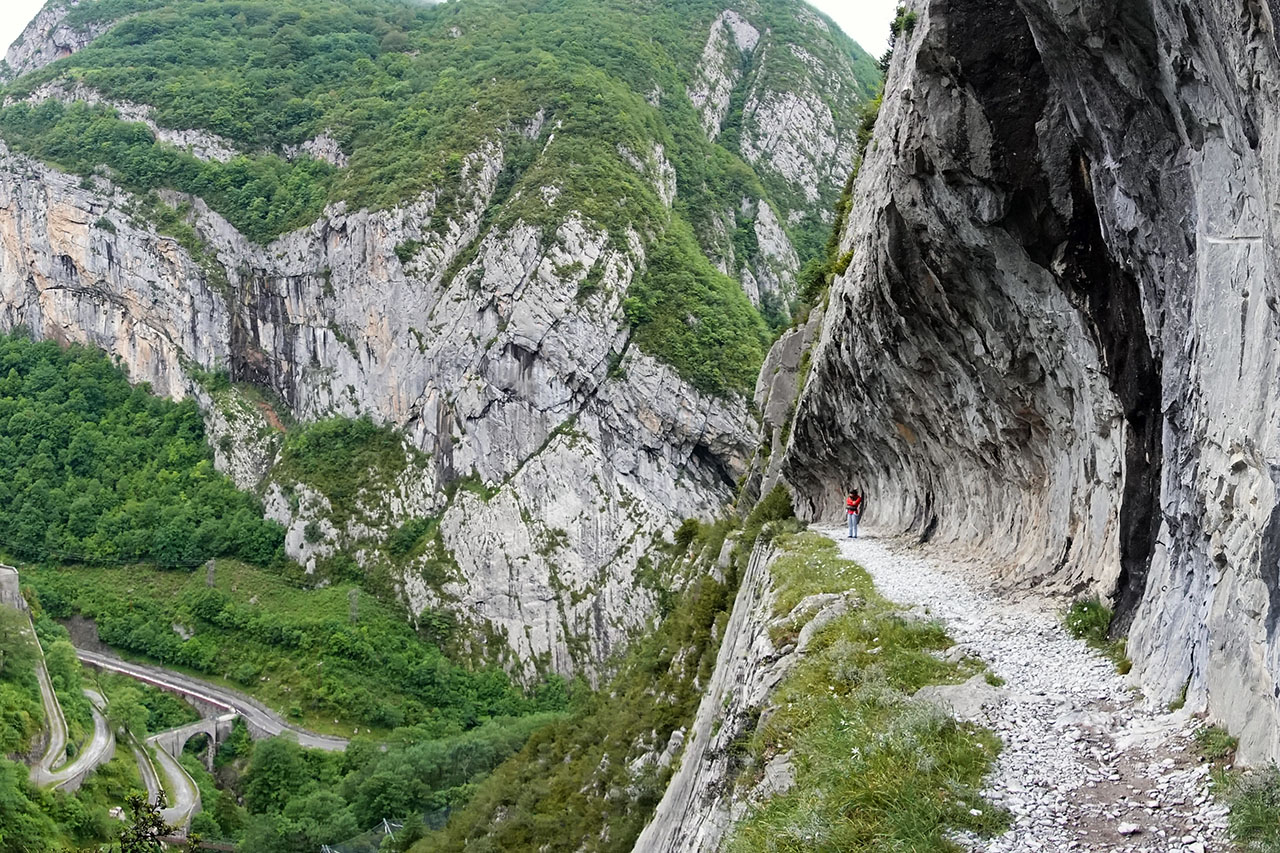
Here 🔥The Chemin de la Mâturetranslated into English as The Way of the MastsThe road was carved between 1771 and 1773 on the steep cliff of the Gorgues de l'Enfer (Aspe valley), which goes all the way up the Sescoué gorge to the Pacq forest. The purpose of its construction was none other than to facilitate the extraction of large trunks of spruce, beech and boxwood for the construction of the great French Royal Navy of the time. This activity was carried out during the 6 years following its construction.
The most spectacular section of the route is less than a kilometre from the small road that climbs from the Pont de Cebers to the Bieus forest. If you are in a car and there is space, you can park it on the first sharp left-hand bend in the road and walk just 1.5 kilometres (one-way). If we go by car or there is no space, we will have to park next to the bridge of Cebers, 500 metres further down.
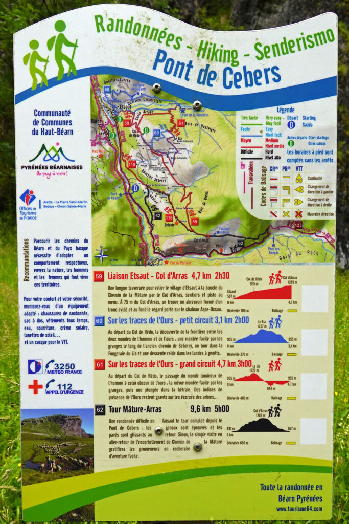
As we said, this is the quickest way to visit the most spectacular part of the Chemin de la Mâture but, if you want to take a walking route, a panel next to the Cebers bridge offers several options.
A bit of history:
During the reign of Louis XIV (1643-1715), a period marked by constant wars, France became the leading European power. This required the creation of a large navy and, consequently, quality timber to augment its powerful Royal Navy.
This fact meant that from that time onwards, between the 17th and 18th centuries, important surveys were carried out in search of the quality wood that was to be found in the forests of the western Pyrenees. And of course, one of them was the Pacq forest, ideal for its beautiful, slow-growing trees, with straight, knot-free trunks, the most suitable for making the masts of large ships.
But getting there was complicated, with impassable walls and vertiginous slopes - even more so if you needed to move all the timber - so they opted to carve a road wide enough to cross the Sescoué Gorge safely, using explosives, so that the oxen used for the heavy work could transport the cut tree trunks to the place where they would be processed. In reality, one pair of oxen to lead the convoy and seven or eight pairs behind to slow it down.
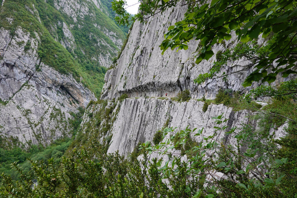
Today, it is one of the most attractive places to visit in this region of the French Pyrenees. An easy route that will delight you with breathtaking views of the ravine and of the Fort of PortaletThe building was declared a Historic Monument in 2005, and although it was built in the 19th century to defend against a possible Spanish invasion, it was eventually used as a prison.
Circular route along Chemin de la Mature or Route 62 (Tour Mâture-Arras)
If you have the time, one of the best ways to visit the Chemin de la Mâture is to carry out the route 62 (Tour Mâture-Arras) which is signposted on the panel next to the Cebers Bridge (see photo of the panel at the beginning of the article).
How to get there
The start of this excursion is located at the Pont de Cebersbetween the villages of Urdos and Etsaut. To get there from Spain, we will cross the Somport TunnelWe will be close to the town of Canfranc. Once on the other side, after passing the village of Urdos and seeing the Fort of Portalet on the right, we will take a detour on the right that crosses the Gave D'Aspe by the aforementioned Cebers Bridge. We arrive at a car park where we can park (motorhomes are obligatory). If there are not too many people, we can go up another half kilometre with the car and park in a sharp bend on the left hand side, where there are a few places, although this is not worth it if what we want is to do the circular route that we propose here.
Itinerary:
We start from the car park of the Cebers Bridge (0h00min). After a few minutes the path sticks to the wall and we get into the Chemin de la MatureThe path carved out of the rock - the most spectacular spot on the route. On the other side of the Sescoué ravine is the Fort du Portalet. We will find two huts (closed), they are the so-called Perry Farm. We drive through a beech forest to reach a turn-off, which we take in the direction of the Col d'Arras (1280m) ( 2h25′) -we have the option of approaching "Pont des Trungas" and observing the torrent-. We start the gentle descent at the beginning, along a well-marked path, with white and yellow markings. The path leads to a track and after a couple of crossroads we reach an asphalted track that we take to the left. We return to the car park ( 5h).