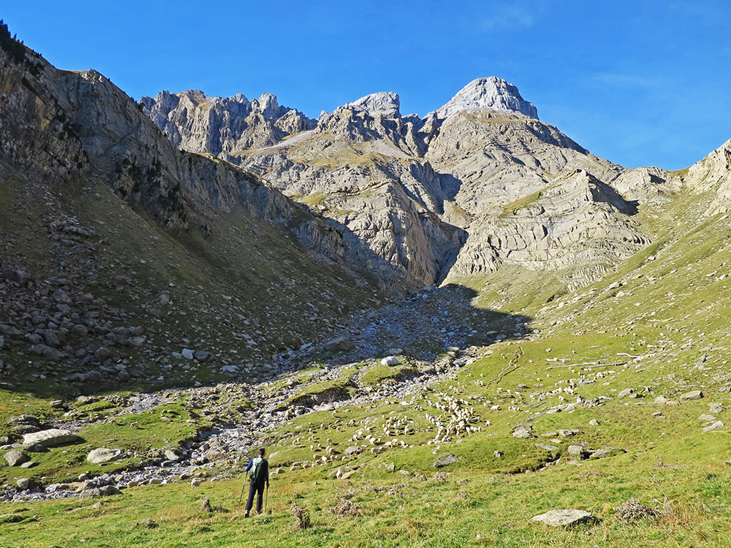
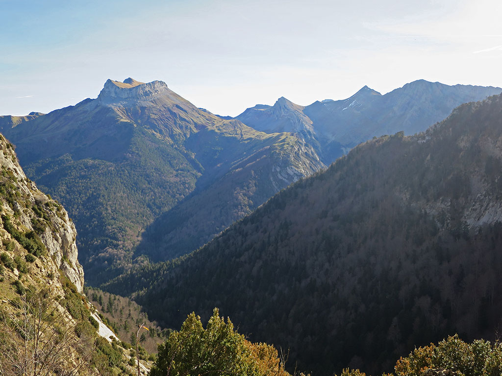
Peña Forca (2,391m) and Rincón de Alano (2,357m) from the Puente de Oza bridge.
Pyrenees and mountains 📩
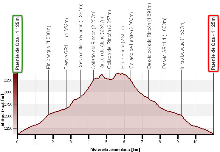
Here 🔥A snowshoe route that climbs the two main peaks of the Sierra de los Alanos: the Peñaforca and the Alano's Corner. The described route starts at the Oza bridge, goes up the Estribiella ravine and comes out into the meadow area that extends below the wall formed by these two peaks. We will first climb up to Rincón de Alano through a steep corridor that ends at the Rincón pass, and then crest up to Peña Forca. The descent will be by the most usual route, that is, via the Lenito pass and the Lenito tube, and then by familiar terrain to the Puente de Oza.
Technical specifications:
Distance: 11.0 km.
Cumulative difference in altitude: +/- 1.373 m.
Timetable: about 6.5 hours Walking time non-stop: 5h40min.
Water: There are no springs, although the Estribiella ravine usually carries water.
Difficulty: The route has no climbing steps. The greatest difficulty lies in going up the steep scree corridor to the Rincón pass. With snow, depending on the conditions, it may be necessary to use ice axes and crampons in this area, on the ascent and descent to Rincón de Alano and Peña Forca and on the descent of Tubo de Lenito. There are hardly any orientation difficulties.
Recommended equipment for the summer: light boots or trekking shoes, walking sticks, GPS (optional), canteensome food, sun protection, sunglasses...
Suggestions: The route can be made completely circular if you go up or down the Barranco de Aguas ravine, where there is apparently a path that crosses the forest and then disappears when you reach the pasture area. The route would be more complete if you go up to Lenito and Puntal de Lenito, in both cases without difficulty.
Itinerary
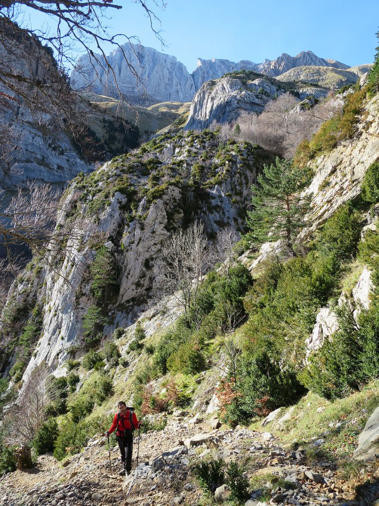
(0h00min; 0,0kms) Oza Bridge (1.125m). At the end of the car park next to the Oza Bridge, a signpost indicates the GR11.1 variant to Zuriza via the Estribiella pass and the ascent to Peña Forca. The path is marked in red and white, and in this first stretch, it coincides with the approach path to the Estribiella ravine, one of the star ravines in the area. The climb is steady and quite steep, under a beech forest that prevents us from seeing the peaks, but which in exchange provides us with good shade on hot days. In a twist in the path (0h40min), the path finally manages to get out of the forest and we can see the Puntal de Lenito (2.285m) and the Lenito (2.339m).
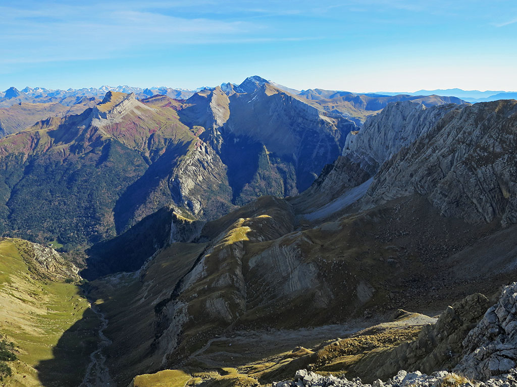
The forest ends shortly afterwards (0h50min) giving way to an area of meadows where our objective reveals itself just in front of us. The Rincón de Alano stands out from the rest, with a slender somite pyramid in shades of white. The greenish-coloured Achar de Alano, on the other hand, goes rather more unnoticed to the left. Behind it, the Château d'Acher closes the horizon.
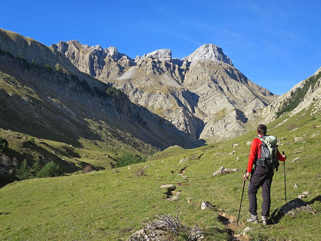
(1h10min; 2,7kms) Path left - we leave GR11.1 (1.652m). Reaching the end of the meadow area, we leave the red and white markings of the Senda Pirenaica to cross the stream and continue along a path marked with milestones in a southerly direction. We head towards a grassy strip where we cross the rocky barrier. The path continues in a southerly direction towards the Lenito pass. We follow it for a while with our sights set on the right, on the Rincón pass. The idea is to go around the rock barrier on the left to access the corridor that leads directly to the Rincón pass.
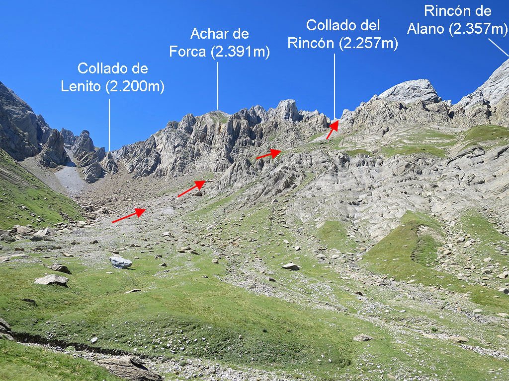
(1h40min; 3,6kms) Leave the main path (1.891m). The path to the Rincón pass, so to speak, is marked with milestones that get lost until they disappear completely. It is of no great importance, it is a matter of overcoming the step at the base on the left and going up the difficult corridor that ends at the top of the...
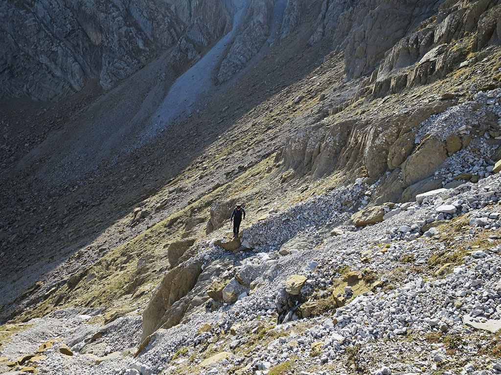
(2h35min; 4,3kms) Collado del Rincón (2.257m). We head first to the right to reach the summit of the...
(2h55min; 4,7kms) Rincón de Alano (2.357m), from where there is a good panoramic view to the north of the peaks in the area and a good perspective to the south of the Peña Forca.
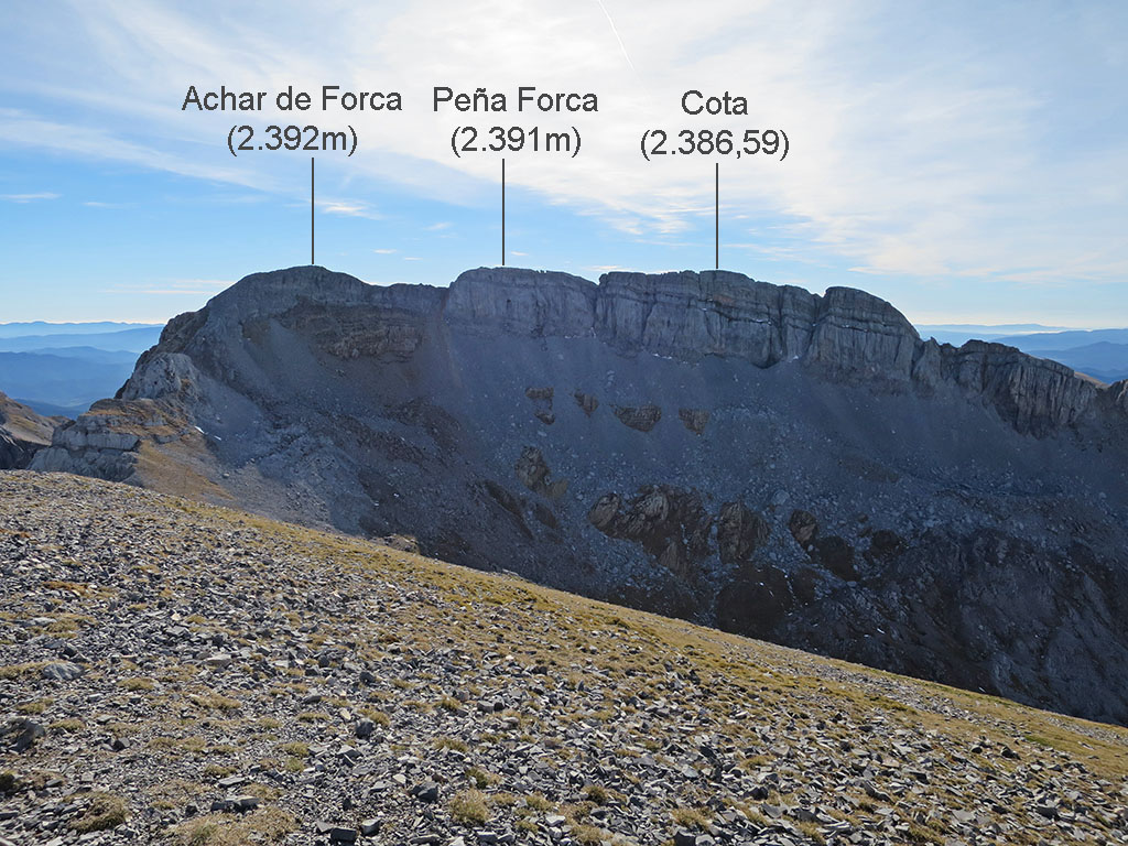
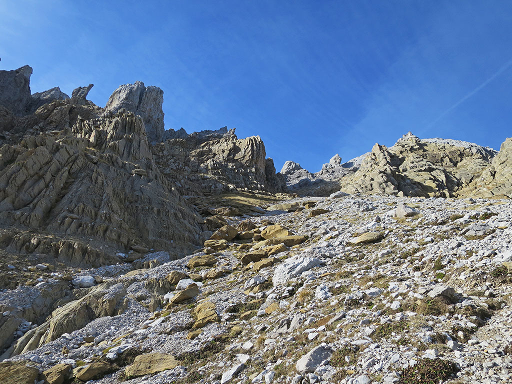
(3h10min; 5,2kms) Collado del Rincón (2.257m). Back at the pass, we continue along the right side of the ridge (west) and then along the left side, towards the Achar de Forca (3h40min) and the...
(3h45min; 5,8kms) Peña Forca (2.391m). The geodesic vertex is located at the second height, some 180 metres away from the first, perhaps higher one. The views lose themselves towards the Navarre Pyrenees, the mountains of Ansó and Hecho, and the first three Pyrenean peaks.

For the descent, return along the same path for about 100 metres and without reaching the Achar de Alano, take a small path to the right (southeast) that descends through the rocky area. It is not long before we reach the...
(4h00min; 6,4kms) Collado de Lenito (2.200m)From there we take a small path towards the Lenito, which is the icing on the cake of this route. With no time for more, we go down the Lenito tube, a stone channel through which in about half an hour we reconnect with the point where we left the path to go up to the Rincón pass.
(4h30min; 7,3kms) Fork Rincón pass (1.891m). The terrain from here on is familiar. So, in just 25 minutes we reach the...
(4h55min; 8,2kms) trail GR11.1 (1.652m)then the...
(5h05min; 9,2kms) beginning of the forest (1.530m) and the end of this route in the...
(5h40min; 11kms) Bridge of Oza (1,125m).
Books / Maps:
- Editorial: The Rambler
- Language: Spanish
- No. of pages: 192
- ISBN-10 : 8495368498
- ISBN-13 : 978-8495368492
- Publication: 2009
The valleys of Ansó, Hecho, Aragüés and Aísa.
Fastpacking is not about going faster. It's about going lighter.
If you come from classic trekking, this is the next step: learning to move with less weight,
more fluid and enjoying every kilometre more.
Join the Outsiders Newsletter and start discovering what lightness feels like.