Stage 1 - Saint Jean Pied de Port - Zubiri.
![Roncesvalles / Photo: Freecat [cc-by-2.0].](https://travesiapirenaica.b-cdn.net/wp-content/uploads/2018/11/Roncesvalles_by-Freecat_cc-by-2.0_800x600.jpg)
Pyrenees and mountains 📩
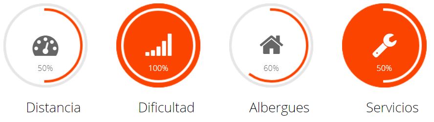
Here 🔥- Total: 49.82 km away
- Maximum height: 1433.27 m
- Minimum height: 172.02 m
- Positive difference in altitude: 1913.03 m
- Negative difference in altitude: 1567.57 m
The Way of St. James Stage One
The beginning of the route shows us how hard it is, as well as all its beauty. A tough stage awaits us to sap the intact strength with which we started our journey. Crossing the Pyrenees has been one of the great challenges for pilgrims since ancient times, but also a set of unforgettable sensations for our senses. Saint Jean Pied de PortThe starting point of our route is the point where the three main roads that run through French territory converge.
Free guide
Camino de Santiago 101
Prepare your first Camino with a quick guide in English and a free community led by a local living on the French Way.
👉 Get free access to Camino 101As it is a town that lives off the Camino, we have many hostels where we can stay overnight before starting our journey (see useful tips on how to get to this point).
We start the hardest stage of the route at the medieval bridge over the river Nive, we continue through the medieval streets of the city until we cross the crumbling walls of the old wall and reach a wooden post. Nailed, next to a shell, we will see a sign indicating Chemin de Saint Jacques de Compostelle, from this point we will find a succession of very hard ramps, we must be careful with the momentum and the feeling of strength that we have the first day and take it easy, to avoid scares and declines in our physical condition that will condition the rest of the way; that will not soften its slope to the small village of Huntto (km5). After Huntto, we take a more gently sloping path with a succession of hairpin bends. After 6.5 km we come to a viewpoint with a panoramic view of Saint Jean Pied de Port, well worth a stop to contemplate this beautiful postcard.
Just one kilometre further on we come to the hostel/bar/restaurant of OrissonIf we haven't replenished our water and supplies in Huntto, this is the time to do so, as the terrain gets tougher from here.
Normally from this point onwards most cyclists do the stage by road because it is too hard, but all cyclists who decide to continue on the road (well trained) will never forget the beauty of the stage and the experience they have had. We continue along a mountain road with steep slopes, and after about four kilometres we come across the statue of the Virgin of Biakorri, adorned with numerous offerings from pilgrims who have passed by. At this point we have left 11.5 km behind us, we still have one kilometre of ascent to go until we reach the Bentartea pass (better known as Napoleon Pass); we realise that the scenery makes us forget the hardness of these first 10-12 km. At this point we start a short descent along a forest track through a beech forest, which takes us to the French town of Arnéguy. At km 15 we come across a wooden sign Roncevaux/Orreaga that shows us that we are in Spanish territory (Navarre). After a crossroads on the right we ascend a stony track that gets progressively harder until we reach the Lepoeder pass, (maximum height of the stage, 1430 metres high), this height is at km 20 of our first stage, from here we can already glimpse the valley of Roncesvalles and see one of the most beautiful landscapes of the Way of St. James.
We come to the first of the many forks along the road to Santiago: either to the left, which is the shortest but with a steep downhill slope (a very beautiful stretch of 3 and a half kilometres) or to the right until we reach the Alto de Santiago. Ibañeta (where the chapel of San Salvador is located (4km stretch). Whatever our decision we will reach the town of Roncesvalles where we can contemplate its collegiate church (starting point of the route for the less intrepid who avoid crossing the Pyrenees).
Roncesvalles is at kilometre 26 of our stage, it has hostels, bars and shops where we can stock up on supplies, but if our strength has left us, it is not advisable to sleep there because it is, as we have pointed out, the starting point of many pilgrims and it will be difficult to find accommodation. We recommend continuing to Espinal km 32 further on without any difficulty, (they indicate that it is a campsite) but in reality it is a well-equipped hostel.
After leaving the Espinal we continue on our way and climb to the top of Mezkiritz which we crowned and after passing through the towns of Bizkarreta y LintzoainAfter a short descent, we ascend the Alto de Erro on a climb with a lot of loose stones and ramps that are quite harder than the Alto de Mezkiritz. Once we reach the top (km 43 of our stage), we are almost at our first destination and the climbs are over, we enter very beautiful forests which we will enjoy, given that the terrain is favourable, after leaving these beautiful places we begin the fast and dangerous descent along a path with a lot of loose stones towards Zubiri. At the end we come to the Rabia bridge over the river Arga, a construction over which we access Zubiri and the Esteribar valley (km 49 and the end of this tough first stage). Zubiri is a beautiful village where we can find all the necessary services.
Stages:
- Stage 1. Saint Jean Pied de Port - Zubiri".
- Stage 2. Zubiri - Puente la Reina".
- Stage 3. Puente la Reina - Logroño".
- Stage 4. Logroño - Belorado".
- Stage 5. Belorado - Hontanas".
- Stage 6. Hontanas - Sahagun".
- Stage 7. Sahagun - León".
- Stage 8. León - Rabanal del Camino".
- Stage 9. Rabanal del camino - Ruitelán".
- Stage 10. Ruitelán - Sarria".
- Stage 11. Sarria - Arzua".
- Stage 12. Arzua - Santiago de Compostela".