Stage 11 - Sarria - Arzua
Pyrenees and mountains 📩
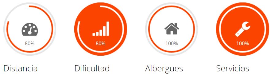
Here 🔥- Distance: 77 Km
- Maximum height: 724.67 m
- Minimum height: 305.8 m
- Positive difference in altitude: 1500.44 m
- Negative difference in altitude: 1539.99 m
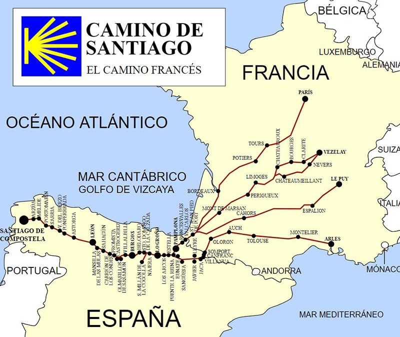
The Way of St. James eleventh stage
This stage will show us all the splendour of Galicia, crossing countless forests and small rivers, small villages and all over a changing terrain from dirt to asphalt in a continuous leg-breaking slide.
As soon as we leave Sarria and after crossing the railway line we enter the first forest (in this case of beech, oak and pine trees) which we leave when we reach the village of As Paredes and Vilei, from here we take a tarmac track to Barbadelo (km 4.5) and Rente; from here along a wooded corridor we reach Mercado da Serra, and continue to Leiman (km 8) which we find as soon as we cross the regional road to Lugo.
We now take a dirt track under chestnut trees towards Cortiñas, Lavandeira and Brea (km 11.5); just past Brea we find the milestone marking 100 km to Santiago (the minimum necessary to obtain the Compostela for walkers, for pilgrim cyclists 150 km are required), a few metres further on is Morgade (km 12) and then Ferreiros.
From here a tarmac track takes us to Mirallos. From here we drive on tarmac to Mercadoiro (km 17), passing through several villages, from here we continue on a tarmac track to Vilachá passing through Moutrás and Parrocha.
All that remains is a sharp and rapid descent along dirt tracks to the Portomarín reservoir on the river Miño, whose village (built new because the old village lies under the waters of the reservoir, except for the church which was transported stone by stone to the new village) is reached after crossing the long bridge over the reservoir and a short but tough climb to the village square.
To leave Portomarín we climb up to San Antonio mountain for 1 km, where the path becomes flat through pine woods, which after a descent brings us to Gonzar (km 30) and from here a further climb of 1 km to Castromaio. Now there is a tough but short climb of 700 metres until we reach the road, which we will cross several times to reach Hospital dela Cruz (km 34).
We will now take the hard shoulder of a road for 10 km in a continuous up and down that will not stop until we reach Pals de Rei, passing through Ventas de Narón, Ligonde, Airexe, Portos, Lestedo and Brea, where we leave the track after 10 km.
Then we ride parallel to the road passing through Avenostre, O Rosario and we reach Palas de Rei (km 48).
We leave Palas de Rei through a continuous passage through villages until we reach a path of eucalyptus and oak trees that leads us to San Xulián do Camiño. From here we reach Pontecampaña via a beautiful 1 km long corridor, and after 2 km of spectacular scenery we arrive at Casanova (km 54). From here in a continuous up and down we leave the province of Lugo and enter the province of A Coruña and its first town Ocoto, which gives way to Leboreiro and San Xoán de Furelos and 2 km further on we reach Melide (km 63) (do not forget to eat octopus a feira in Ezequiel).
We enter a forest of eucalyptus trees and innumerable corridors in a continuous leg-breaker, leading us to the end of the stage, passing first through the villages of Castañeda where we take a tarmac track to Ribadiso da Baixo, from where we ascend for 3 km on tarmac until we reach Arzua, the end of our stage through the lands of Lugo.
Stages:
- Stage 1. Saint Jean Pied de Port - Zubiri".
- Stage 2. Zubiri - Puente la Reina".
- Stage 3. Puente la Reina - Logroño".
- Stage 4. Logroño - Belorado".
- Stage 5. Belorado - Hontanas".
- Stage 6. Hontanas - Sahagun".
- Stage 7. Sahagun - León".
- Stage 8. León - Rabanal del Camino".
- Stage 9. Rabanal del camino - Ruitelán".
- Stage 10. Ruitelán - Sarria".
- Stage 11. Sarria - Arzua".
- Stage 12. Arzua - Santiago de Compostela".
Fastpacking is not about going faster. It's about going lighter.
If you come from classic trekking, this is the next step: learning to move with less weight,
more fluid and enjoying every kilometre more.
Join the Outsiders Newsletter and start discovering what lightness feels like.