Stage 6 - Hontanas - Sahagun
Pyrenees and mountains 📩
Here 🔥- Distance: 95 km
- Maximum height: 910.15 m
- Minimum height: 766.1 m
- Positive difference in altitude: 621.64 m
- Negative difference in altitude: 652.01 m
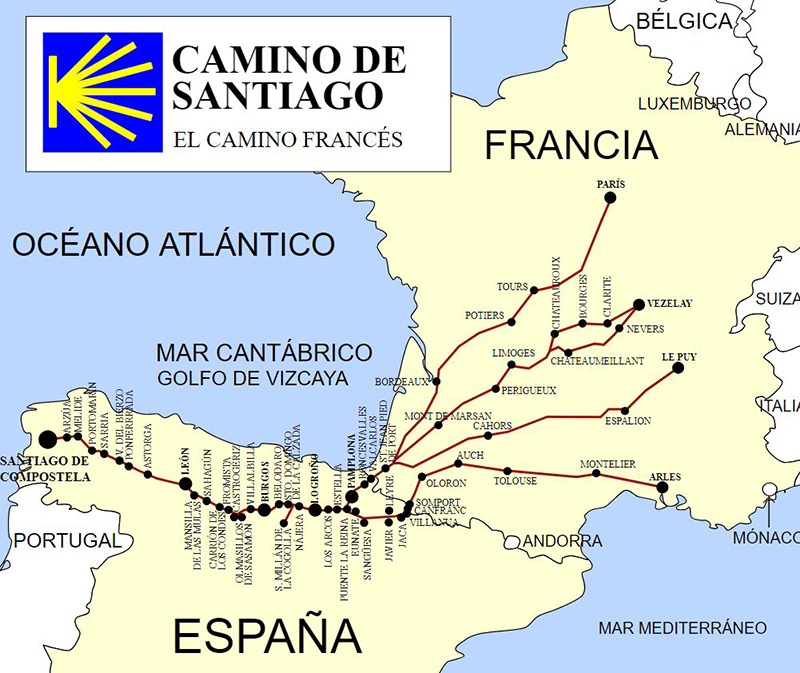
The Way of St. James Stage Six
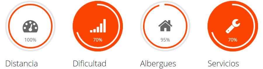
The hardness of this stage lies more in the mileage, which is around 100 km, rather than the orography of the terrain, although on a day with a headwind it can be interminable and a harsh punishment for our already punished body.
Free guide
Camino de Santiago 101
Prepare your first Camino with a quick guide in English and a free community led by a local living on the French Way.
👉 Get free access to Camino 101Another curiosity of this stage is that we cross the entire province of Palencia from east to west, so let's get ready for kilometres of long stretches of road.
We start our way through a cultivated valley, which leads us to Castrojeríz (km 9.2).
As soon as we leave this village we come across the only real mountainous difficulty of the stage, the Matamulos pass (1.3 ascent with an average gradient of 12%). If the ascent is hard and short, be careful with the descent, which is fast and dangerous (18% difference in altitude).
Four kilometres further on, following the path, we reach a picnic area next to the Fuente del Piojo fountain (Km 17).
In just one kilometre we come across the old parish church of San Nicolás (today a pilgrims' hostel), and then after crossing the river Pisuerga we enter Palencia (a province that we will not leave until almost the end of the stage).
A country road leads us to Itero de la Vega (km 20), the first town in Palencia, and through farm tracks we reach Boadilla del Camino (km 28.5). We take a lane parallel to the Canal de Castilla (nice route) until we reach Frómista (km 34).
From this point onwards, there is a walkway parallel to the road for 18 km, which is only broken by passing through towns such as: Población de Campos, Revenga de Campos, Villarmentero de Campos, Villalcázar de Sirga until reaching Carrión de los Condes (Km 54).
At this point we are only half way through the stage and we have already had quite a lot on our shoulders. From here we head towards Calzadilla de la Cueza (km 71) along an interminable and stony straight stretch of 13 kilometres. Stock up on water, as there is no drinking water on this stretch. We take a road parallel to the National 120 (which we will cross several times) that leads us up and down to Ledigos (km 83.4), we continue parallel to the road until we reach Terradillo de los Templarios (km 86.6).
We now take a dirt track that leads us to the village of Moratinos (km 89.3), where we can see its typical mud houses.)
In 2 and a half kilometres we reach the last village in the province, San Nicolás del Real Camino.
Without further ado, we return to the national road 120, along a pilgrim road that will take us to Sahagún (km 95 of the stage). Here we will rest after this long day.
Stages:
- Stage 1. Saint Jean Pied de Port - Zubiri".
- Stage 2. Zubiri - Puente la Reina".
- Stage 3. Puente la Reina - Logroño".
- Stage 4. Logroño - Belorado".
- Stage 5. Belorado - Hontanas".
- Stage 6. Hontanas - Sahagun".
- Stage 7. Sahagun - León".
- Stage 8. León - Rabanal del Camino".
- Stage 9. Rabanal del camino - Ruitelán".
- Stage 10. Ruitelán - Sarria".
- Stage 11. Sarria - Arzua".
- Stage 12. Arzua - Santiago de Compostela".