Haute Route Panticosa-Wallon on cross-country skis
Pyrenees and mountains 📩
Here 🔥The Pyrenees offer a wide variety of routes and crossings for skiing enthusiasts during the winter and early spring. This is when, between March and AprilThe route described below is recommended: the High Route Panticosa-Wallon. At this time of year the temperature is usually more pleasant, and the snow is usually more settled. This route is technically simple, but it requires a decent level of fitness, as it takes two days to complete. However, if you have more days to enjoy the mountains, the variants that this route has to offer are endless. You can extend the journey by going to Respumoso or Oulettes de Gaube for example. However, if you have two days off in a row, put on your skis and venture out on this route, but not before reading the indications we will give you below. It is worth mentioning that these indications are orientative, and that it is highly recommended that you carry a GPS at hand with the recorded track, so that you don't get lost along the way.
Stage 1.
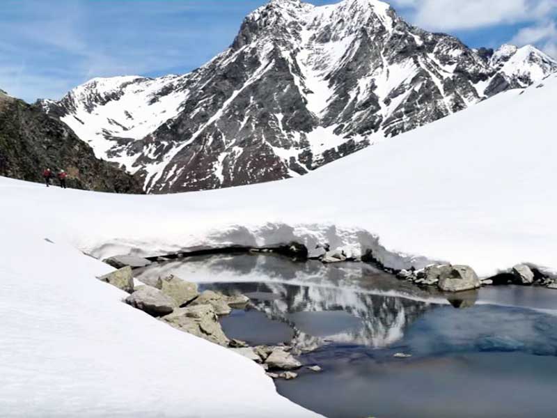
The first day of the route starts at the Panticosa Spaand ends at the Wallon Hut. This refuge is situated at an altitude of 1,865 metres, and is usually open every day except in December and January. The first stage has more than 17 kilometresand it is estimated that it can be completed between 5 or 7 hours. Although it does not present considerable technical difficulties, it is certain that the 1,400 metres of positive difference in altitude They are tiring, and very tiring too. The route, as we will specify below, has two ascents and two obvious descents. The journey begins by overcoming a fairly steep slope. towards the Bacías Peak. The first climb of the day is about 5 kilometres long, and it ends at the Old Port of Brazato. At this pass we leave the normal route up to Pico Bacías to the left. From the pass the descent begins. towards the Ara Valleyunder the feet of the emblematic VignemaleThis is one of those peaks of over 3,000 metres that should not be left unclimbed. However, we will continue along the beautiful descent on wide snow slopes. When you are about 2,150 metres above sea level you can take a variant that can be very practical when there is not much snow at the bottom of the valley. Without having to descend to the bottom and climb back up again, you can take a diagonal route without excessive difficulty. However, this route can be somewhat dangerous if the snow is unstable. In this section you will have to overcome a fairly steep corridor, but it can be climbed on foot, without the need for climbing techniques. Once you cross the corridor and reach the high plateau, you will have to continue ascending through the snow towards the Col d'Arratille. During the ascent, the imposing northwest face of the Vignemale will cover your back. A side of this mountain that is not well known by many mountaineers. The views are certainly worth the effort. Once you have reached the top of the pass you can enjoy the second descent of the day towards the Wallon Hut. During the descent you will be in French territory. The descent is gentle and comfortable, interspersed with downhill and flat areas. It is likely that at the bottom of the valley you will have to carry your skis because of the lack of snow. With your skis on your back you will overcome the last steep slope to get to the Wallon Hut. The views from the hut are magnificent, and you will be able to see the objective of the second day: the Marcadau pass.
Stage 2.
The second day is a little shorter, but the more than 1,200 metres of positive difference in altitude The day begins with the first objective of the day in sight. The day begins with the first objective of the day in sight. The Col de Marcadau is a pass situated at an altitude of 2,541 metres. The climb up to the pass is quite long but easy, and can take about two hours. The route starts on a flat path that leads to the bottom of the valley. It is then that the first ramps appear. However, they are not very steep and are fairly easy to overcome. At the top of the pass you will be back in Aragon. The descent starts on a wide slope in the direction of the Ibón de Bramatuero Bajo. The slope leads to a corridor that becomes steeper and descends through the Barranco de la Canal ravine. This section is very popular with mountaineers, so the descent can be a little uncomfortable due to the visible footprints. Once the corridor ends, walk to the left, following a diagonal until you reach the lake. This is the end of the descent, and the sealskins must be put on again to face the ascent to the Collado Xuansat 2,757 metres. The climb is fairly flat, but it tends to be long, as there is a difference in altitude of around 600 metres to overcome. During the ascent you will have Peña Xuans in front of you; the pass is just to the left. On the pass, you will be able to see the first peak of the Dientes de Batanes. It is highly recommended to climb it, as the views are fantastic. After overcoming a gentle slope and a simple ridge, you will be at the summit of the Batanes Western Tooth at 2,875 metres. The descent to the Balneario de Panticosa is very direct and fun. The first part of the descent is on the west face of the mountain. After descending about 100 metres, you have to look for a pass towards the western slope. During this stretch you will be skiing under the Dientes de Batanes. The descent should be made with a diagonal tendency to the left, in order to find the path you climbed the previous day towards Pico Bacías. From there, the route is easy to follow and you will soon be at the car park of the Panticosa Spa.