How to read a map for hiking

For trekking you will need basic equipment to make it comfortable and, above all, safe. Among the basic items for trekking are topographical maps.
In this article we will go over everything you need to know to interpret a topographic map: the scale, contour lines, the legend, its orientation, etc. The texts have been accompanied by videos. Training Capsules of the Spanish School of High Mountain FEDMEThe report is available in a comprehensive guide on the subject.
Topographic maps: what are they about?
Topographic maps are not the same as the ordinary maps you can buy at the nearest gas station or convenience store. On the contrary, they are specialised maps with a high level of detail.
These maps show the world perpendicular to the terrain. They are very useful as they include both natural and man-made features, as well as the topography of the land.
They have contour lines that represent the topography and connect to points that have the same elevation, allowing you to visualise everything as if it were a landscape. A topographic map is able to "show the 3D world on a 2D surface".
How to read a topographic map
Learning to read a topographic map is vital for you to have a deep understanding of the terrain to be explored. Learning starts with interpreting the following:
Contour lines
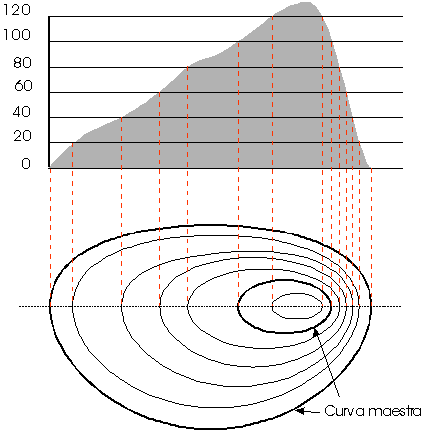
Contour lines are the main indicators of the slope of the terrain. They are connected to points that share or have the same elevation. For example: when they are very close, but do not intersect, they mean that the elevation is changing very fast over short distances.

They also denote that the terrain is steep. You should know that when contour lines are far apart, the elevation changes slowly; this means that the slope is gentle.
But they indicate not only the slope, but also the shape of the terrain. In addition, some concentric circles tend to show a peak, while the areas between the peaks are the dividing ones.
An easy way to interpret contour lines is as follows: if a line is marked as "1,200 m", this means that all those points on the map are located at 1,200 metres above sea level.
The difference in height between contour lines is called equidistance, which depends mainly on the scale of the map, and sometimes on the landscape depicted. The most frequent are 5, 10, 20, 40, 80 or 100 m.
2. Index or master curves
You should know that every 5th contour line has a coarser "index" curve, and that at some point along that line its exact elevation is detailed.
3. Equidistance between contour lines
As mentioned above, the change in elevation of a contour line, relative to the next contour line, is always equal within the same map.
Do you know what an equidistance of 25 m is? If the answer is no, don't worry: here we tell you: a contour line is located 25 m vertically from the next closest line.
You can find out the equidistance of your map by looking at the map legend or by exploring the changes in the contour lines on the map itself.
4. Representation of peaks, troughs and valleys
A circle (contour line) indicates a trough or peak. That's right, a circle with marks inside it indicates a trough. But this is not the only thing to look at; be sure to see how the elevations decrease as you approach the trough or the opposite if you are talking about a mountain peak.
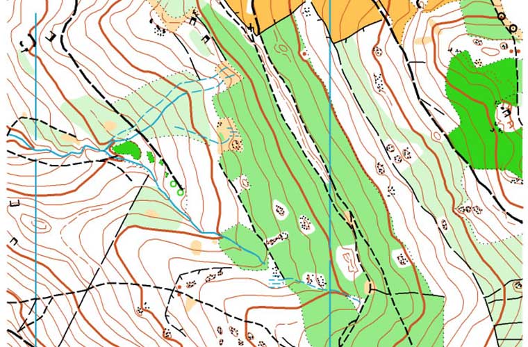
Valleys, on the other hand, are represented by a series of contour lines that are U- or V-shaped and point to a higher elevation. A simple way to detect or identify if a valley has a stream is to see if it has a blue line, as this divides the contour lines.

Scales of topographic maps
As a planimetric map it is more than obvious that it has scales. These indicate how detailed this sort of photograph of the terrain you are exploring is. Numerically a scale of 1:25000 means that one cm on the map actually equals 25,000 cm on the ground.
If it is a larger scale, e.g. 1: 250,000, it means that the map covers a larger area, but with a smaller amount of detail.
Another important point to keep in mind is that topographic maps also include a representative scale - a graphical scale - that allows you to visualise distances in the real world.
In essence, you can use such a scale and a rope, or even the edge of a compass, to get a rough estimate of trekking distances from the map.
Legend of the planimetric map
Never underestimate the legend of your map. It is loaded with useful and valuable information that will help you better read what it contains. You will get clues and navigational data through its lines, symbols and colours.
Yes, even colouring has a meaning and can be interpreted. In this sense, as a general rule, darker shades refer to denser vegetation, while lighter or colourless areas refer to open terrain. As far as streams, rivers and lakes are concerned, they are identified by the colour blue.
Hikers also pay attention to grid systems and magnetic declination. The former is useful for more advanced navigation, and the latter is appropriate for setting location features such as a compass.
A basic aspect of reading a map is that it will mark North at the top of the map. Using a compass together with the map will allow you to point the map in the right direction.
Other notable features of the maps
Topographic maps can be categorised as follows:
1. Cultural / Tourist
From this, roads, buildings, power lines, railways, urban spaces and borders can be identified. They incorporate tourist and cultural elements.
2. Aquatic
They read rivers and streams, lakes, seas, marshes and waterfalls.
3. Natural
They read forests, orchards, vineyards and parks.
4. Relief
They identify mountains, canyons, depressions, plateaus, slopes and valleys.
5. Place names
They read out the names of places, water sources and locations.
In short...
- Topographic maps allow you to visualise the three-dimensional terrain from a flat sheet of paper, thanks to contour lines or contour lines.
- Contour lines form loops and these are indicated by intervals or equidistance.
- The colours make the map easier to read.
- Nowadays, many publishers produce topographical maps for trekking and outdoor activities.
- The most complete maps on the market have the traces of the most important or primitive paths and all the elements of interest that can be found around them.
READ ALSO:
Fastpacking is not about going faster. It's about going lighter.
If you come from classic trekking, this is the next step: learning to move with less weight,
more fluid and enjoying every kilometre more.
Join the Outsiders Newsletter and start discovering what lightness feels like.
