Hollyford-Pyke Loop Trail (New Zealand)
Pyrenees and mountains 📩
Here 🔥The Pyke River is situated in the Fiorland National Park on the South Island of New Zealand. The route is a fairly straightforward 10-day trek for those who are fit, experienced and well equipped.
Practical guide for hikers
Throughout the walk you will experience a sense of isolation and adventure. The contact with nature and the solitude you experience increase the feeling of belonging to nature.
The first day we walked from Hollyfros Roann to Hidden Falls Hut. It is about 9 km long and takes 2-3 hours to complete. During this section you will walk through a tropical forest, full of green bushes and a myriad of waterfalls. A 2-minute detour takes you to Hidden Falls, a place well worth a visit. During this stretch, only the most experienced can go packrafting. It is very complicated because the water level is very high and there are many rapids in the river. We will rest at Hidden Falls Hut.
On the second day there will be a 7.5 km and 10.2 km paddle route. This will take around 4 hours. On this section we will have stunning views of the mountain range at the Hollyford Crossing and the Pyke Rivers. There are also excellent views of the lake, valley and surrounding mountains. We will camp at the end of the trail on McKerrow Island.
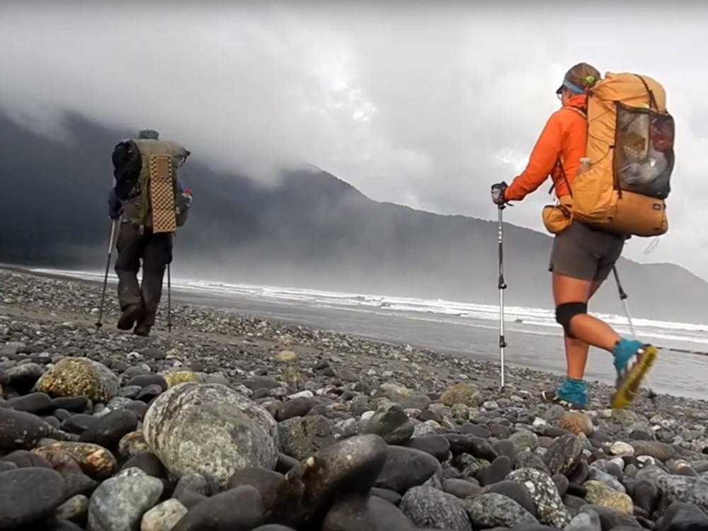
The third day will be a 13.8 km walk, which will take between 5.5 and 7 hours. The trail is through the jungle and is very pleasant unless the weather starts to turn bad. It is important to follow the orange markings along the way. There are about three bridges to cross. It is possible that there will be strong winds which will slow down the pace. You will rest in Hokuri.
The fourth day consists of a walk between Hokuri and Martins Bay. At 4-5 hours and 13km in length, it is an easy walk. The views over Martins Bay are spectacular, especially at sunset.
On the fifth day the route will be between Martyns Bay and Big Bay. It consists of a 16 km route which takes about 5 to 6 hours to complete. There is a large colony of seals at Long Reef. The breeding period is between November and February so it is possible to see pups. The juveniles are also very curious and often come close to the shore.
The sixth day will take us between Big Bay to about 2 km south of Pyke Crossing. This route is 18 km long and takes between 4 and 5 hours. The road from Pyke Crossing to Pyke is fairly straightforward but then it starts to get more difficult. It is a good idea to do the extra 2 km so that the next day you can start more quickly. Tonight we camp in a spectacular camping area. The views are unbeatable.
The seventh day will be an 11.7 km route and takes approximately 5 hours to complete. This route starts at Pyke Crossing and ends at Olivine. It will be a completely packrafting route. It IS one of the best days of the route. The scenery is superb and the route is fairly easy. The wind can be quite strong at Wilmot Lake.
Day eight, the penultimate day, will run from Olivine to Alabaster. It is almost 16km long and will take 5-6 hours to complete. The wind is very strong on this part of the route so caution should be exercised.
The last day of the route will consist of crossing from Alabaster to Hollyford Road. It is 19.5 km long and takes 4-5 hours to complete. This part of the route will be entirely on foot and will consist of the same route as the first stage. This part of the stage is not complicated in any way.
Advice for hikers
It should be noted that the route will be done on foot and packrafting. It is a route that can be done by people who have previously done some kind of rafting experience. Some of the stages can be quite tough, so only experienced people will be able to cope with both the weather and the sections of the different stages.
There are not many places along the route where you can stop to recharge your batteries. It is important at the start of each route to include in your rucksack all the food you need to face the challenge. As it is a route that has many unforeseen events, it is recommended that you always carry a small kitchen kit and plenty of food, as you may have to spend the night somewhere before arriving at a base and you will need to have dinner and breakfast.
Taking into account all the complications that can occur along the way, it is advisable to make a detailed planning. It is important that the route includes all the details and that the route is followed. This will make it easier for the search and rescue team to rescue them in case they get lost. It would be even better if a family member had a copy of the plan.
In case you do not manage to finish the walk, you should not give up. Many people do not manage to cope with this walk, it requires a lot of fitness and effort to be able to reach the finish line. Training beforehand will help to make the effort easier.
Fastpacking is not about going faster. It's about going lighter.
If you come from classic trekking, this is the next step: learning to move with less weight,
more fluid and enjoying every kilometre more.
Join the Outsiders Newsletter and start discovering what lightness feels like.