The best hiking routes in Las Hurdes and Las Batuecas
Pyrenees and mountains 📩
Here 🔥The region of The Hurdesnorth of Cácerestogether with Las Batuecassouth of Salamancais a mountainous territory (Central System) of a great natural, scenic and cultural wealththat needs to be discovered in peace and quiet. A place far from mass tourism that offers countless possibilities for hiking, the best way to get to know it.
The Hurdes
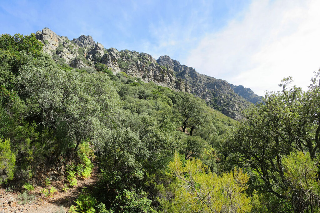
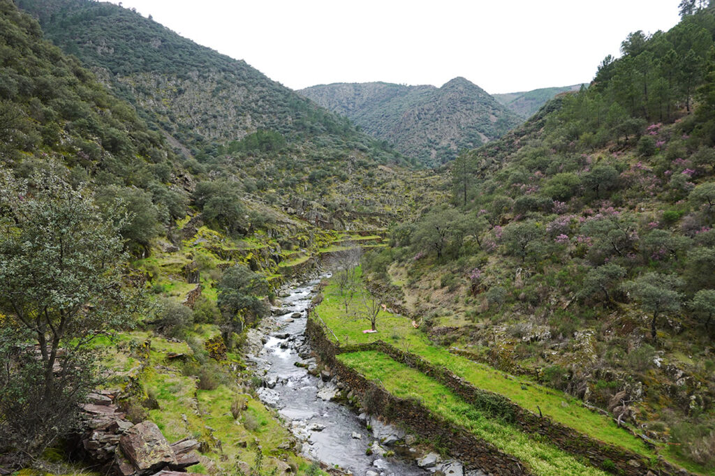
As nowhere else in the Central SystemWhen you go into the The HurdesThe visitor experiences the sensation of being completely surrounded by mountains. Although there are no great heights, the relief of Las Hurdes is chaotic and sinuous, formed by a disorderly succession of mountain ranges (Corredera, Horno, Granjera, Mestas, Carrascal, Cordón, Jineta, los Ángeles...) and intricate valleys (river Malo or Ladrillar, Hurdano, Malvellido, Esperabán, Ovejuela, de los Ángeles...), in which the rivers have drawn impossible meanders.
The Hurdestogether with Las Batuecasvalley belonging to the municipality of La Alberca in SalamancaIt forms a single geographical unit. It is a natural area of great interest that continues to the west with the Sierra de Gatato the north-east with the Sierra de Francia (Las Batuecas Natural Park - Sierra de Francia) and to the south and east with the comarca of Cáparra - Lands of Granadilla.
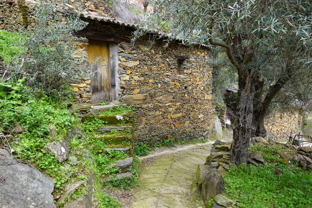
A natural paradise to be discovered from which we cannot leave without visiting its villages, traditionally known as "concejos" and "alquerías" (the smallest ones), with the typical architectureThe roofs of the blackboard and dry masonry walls; its rural surroundings, with a system of terraces of a heroic agriculture; the rock engravings or petroglyphsThe Romanisation of Las Batuecas (from 8,000 BC to the Romanisation of Las Batuecas), which dates from 4,000 BC; its gastronomy (the famous honey, the Gata-Hurdes denomination of origin olive oil, grilled meats, caldereta de cabrito, patatas meneas, migas...); or the natural poolsA must if you visit in the summer.
The best hiking routes in Las Hurdes and Las Batuecas
The Must-Haves
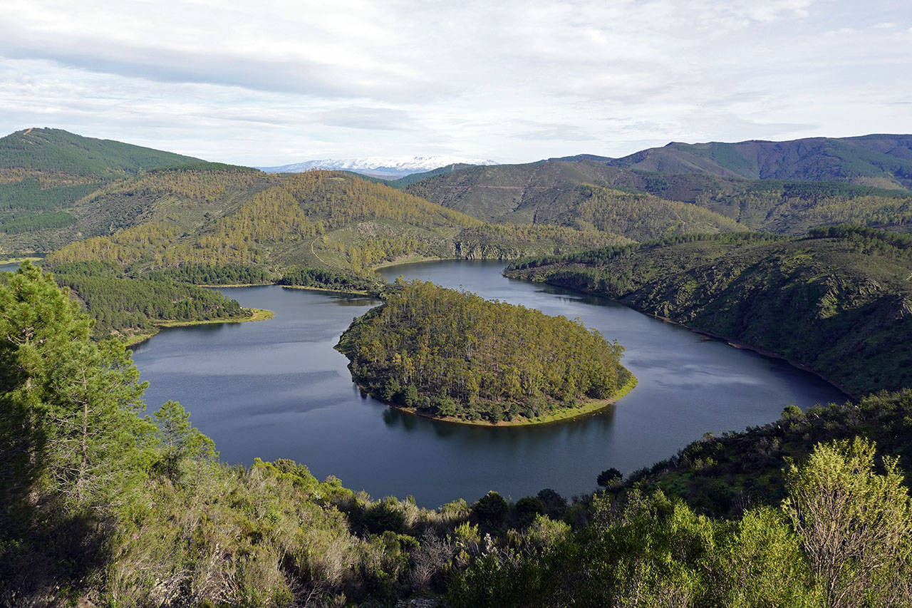
1) Melero Meander
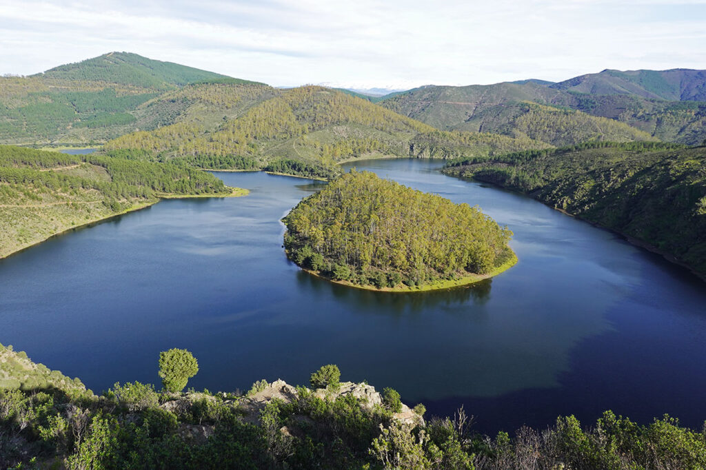
More than a route, what is worthwhile is to visit the Viewpoint of Antigua. To get there (see in Google Maps), you can drive from Riomalo de Abajo on a concrete track of about 3 km, in good condition.
This meander, drawn by the river Alagón at the entrance to the Gabriel y Galán reservoir, is the most impressive of the many that can be found in the area and marks the boundary between Extremadura (Cáceres) y Castilla y León (Salamanca)between the municipalities of Caminomorisco and Sotoserrano. From the viewpoint, the island, a hill of eucalyptus trees connected to the mainland by a thin thread of land, is striking.
Circular route to the viewpoint and descent to the meander
If you want to make a route (4-5 km) and descend to the meander. We can park the car 1.5 km before the viewpoint and walk to it. From the viewpoint you will see a horizontal path that then descends but, to take it, you will have to continue some 200 metres further along the track and go down a very steep firebreak. Once on the bank, if the meander is dry, we can walk along it following the course of the Alagón. To return to the car, take a wide path (N) that leads through the forest back to the car park.
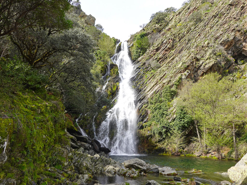
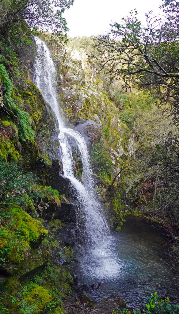
2) Chorro de las Batuecas
The Chorro de las Batuecas is a 12-metre high waterfall that is the icing on the cake of a route that starts at the monastery of San José and who visits the cave shelters of "El Canchal del Zarzalón"and the "Painted Goats".
The route, which is about 10 km long round trip, runs along the canyon formed by the river Batuecasthrough a Mediterranean forest where holm oaks, cork oaks and pines predominate. The vegetation becomes cooler as we approach the pool over which the waterfall cascades and which a path allows us to contemplate from above.
During the route, it is worth taking a detour to contemplate some of the petroglyphs that adorn its caves. The conjunto de arte rupestre de las Batuecas (Las Batuecas rock art site) is one of the most important in the Iberian Peninsula due to the number of locations, more than 30, and its quality. The representations we find here belong to what is known as the Schematic Rock PaintingThis type of art was widespread throughout the Iberian Peninsula between 4,000 BC and 2,000 BC. Here, in Las Batuecas, we find some representations prior to 6,000 BC.
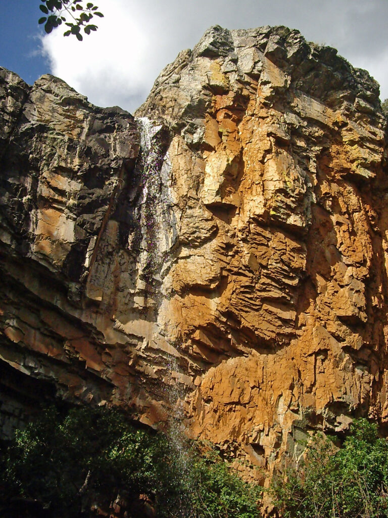
3) Chorro de la Meancera o Miacera
With a drop of about 100 metres, the "Chorro de la Meancera o Miacera". is one of the highest and most beautiful waterfalls of Extremadura.
It is located near El Gasco. To visit it, a 3 km round trip, perfectly conditioned path starts from this farmhouse, following the course of the river downstream. Malvellido river. The beginning runs between small orchards cultivated in terraces in the traditional way, the only one allowed by this steep terrain. Just before joining the Miacera streamThe path turns to the right (south) to go up through a beautiful gorge and, after several switchbacks, reaches the base of the waterfall.
If you want to take a longer route, visit the meanders of the river Malvellido below, walk between terraces and see old Hurdano dwellings, we recommend you continue straight on until you reach the place where the Miacera stream joins the river Malvellido and do the route between El Gasco and Fragosa / Martilandrán (route 7). See below this proposal. Also here, in El Gasco, we recommend you the route to the "volcano" of El Gasco (route 6) and longer (10 km one way), the from El Gasco to Horcajo through the uninhabited area of El Moral and Lombo de las Viñas.
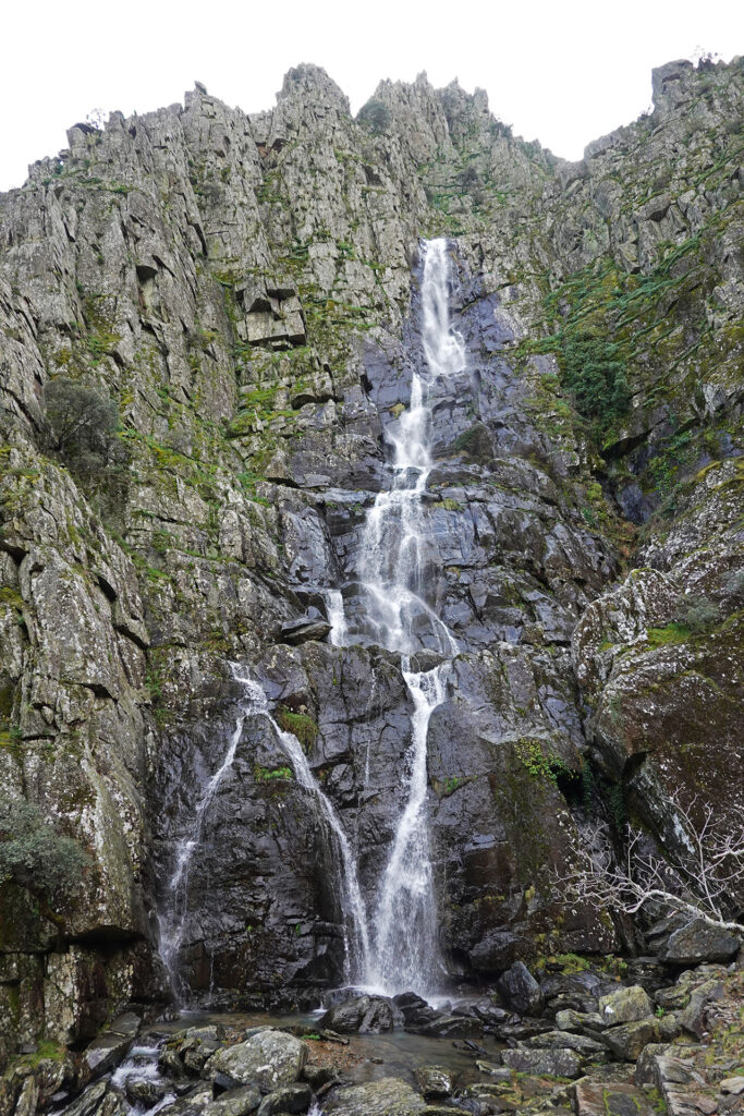
4) Chorrituero of Ovejuela
Another spectacular waterfall is the Chorrituero of Ovejuelaformed by a 70-metre high waterfall that plunges into the sea. Charco de la Tinaja.
It is located 1.8 km from this farmhouse in the municipality of Pinofranqueado. To get there, we start from Ovejuela following a well-marked path that, after crossing the village and passing next to the natural poolThe path goes up the Ovejuela river. The path is pleasant, at first between terraces, stone walls, slate and more slate, small patches of woodland and a lot of scrubland, with the omnipresent heatherwhich can be found around mid-March with their characteristic pink flowers in full bloom, and the rockroseswhich flower a few days later, towards the middle or end of March and beginning of April, depending on the year.
Like most waterfalls, the best time to visit is during the rainy months (especially in spring, if the spring has been generous). On hot days, don't forget to bring a hat as there is little shade and the slates get quite hot. In summer the waterfall does not look the same but it is compensated with a dip in the pool at the beginning of the route, one of the largest in the north of the country. Cáceres.
Circular route to the Chorrituero
If we want to do this circular routeWhen you get to the Chorrituero, you will notice a path that climbs steeply uphill for about 100 metres and connects with the GR10 (Valencia - Lisboa). We only have to follow the red and white markings on the left to return comfortably, always downhill, to Ovejuela.
Other routes/places to visit near Ovejuelain addition to the people themselves, are: the pre-Roman settlement of "Otulia" or "Vitulia".the convent and the waterfall of the Angels (over 100 metres high) and the Los Machos Bridge.
Other routes / places to visit
5) Huetre - Mirador de la Pregonera - Chorro del Ceño
Beautiful route of about 10 km that starts in the village of Huetre up the valley of the Hurdano River and whose main points of interest are the Pregonera viewpoint and the El Ceño waterfall. The route has several possibilities to extend it (up to the Charco de la Serpiente and Majá Robledo) and the problem of not being able to cross the Hurdano river to access the El Ceño waterfall if it is too high.
6) El Gasco Volcano
This natural monument of scientific interest is located on the Castle Peaknext to the farmhouse of El Gasco. Its uniqueness is due to the appearance of rocks with a volcanic appearance that only originate from the transformation of the existing rock by means of an extraordinary increase in temperature (specifically, the element found is ringwoodite, something unique in the world). Three hypotheses have been put forward to explain this: the eruption of a volcano, the partial melting of the rocks that formed the internal structure of a wall of logs and stones, and the one that seems to be the definitive one, the meteorite impact a million years ago.
The route is signposted in the village with an information panel, and is 1.2 km long (one way) with almost 300 metres of vertical drop. Of course, if you do it, you will not take any "souvenirs" of the place with you.
7) El Gasco - Chorro de la Meancera - Fragosa / Martilandran
See route to the Meancera / Miacera stream. Once at the crossing that leads to the Meancera stream, go downstream along the twisting course dug out by the Malvellido river to Fragosa (4-5 km), between terraces that seem to teleport us to China or Nepal (no kidding, although they are not rice fields), is one of the most beautiful routes that we can do in Las Hurdes. If you have stopped at the viewpoint on the road to El Gasco, you will already have an idea of what this route is like. The route is marked as far as Martilandrán, crossing the second bridge. We recommend crossing the first bridge to enter Fragosa The last kilometre of the route from Fragosa to Martilandrán is by road. The return is by road, although it is also possible to go back and return along the terraces on this bank of the river to near El Gasco.
8) Las Carrascas viewpoint
The Carrascas viewpointIt is at an altitude of 1,150 metres and is reputed to offer the most extensive views in Las Hurdes. It can be reached by car on a tarmac road linking Riomalo de Arriba, in the Ladrillar valley, with Robledo, in the valley of the Hurdano river.
9) Chorro de Arrobatuequilla or of the Batuequilla
This 20-metre-high waterfall is located next to the very small farmhouse of Batuequilla. From here there is a beautiful 2 km long trail that runs upstream along the Batuequilla ravine until it reaches a track (accessible in a normal car). The path up to this point can be complicated if the river is very high, as it crosses it twice. From the track there are only 300 metres to go, which is not suitable for small children or people who are afraid of heights. The waterfall can also be seen from above, although once again, the path has a section with quite a steep drop, very easy but dangerous if it is wet. In the small pool that forms below the waterfall there are some yew trees.
The return journey can be made by the same route but, if we want to make the circular route and return along the track, which offers good views that are well worth the effort. Recommended.
10) Yew Valley
The Yew Valleyin the Garganta del CerezalIt conserves 56 of the 230 yew trees distributed in Extremadura. For its conservation, a protected area of some 13 hectares was created in 1999. If you would like to visit it, you can start the route at the Nuñomoral II or Arrocerezal reservoir. From here it is only 2.7 km but with a difference in altitude of 470 metres.
11) Chorrerón del Tajo o Salto del Alavea
This waterfall, located at 5 km from Caminomorisco (9km along a track), can be seen from the viewpoint of Alavea, which can be reached by car from Caminomorisco.
12) Los Angeles Jet
The Los Angeles jetThe waterfall, more than 100 metres high, is located in the municipality of Pinofranqueado. Since 2022, it has had a viewpoint which can be reached by car along a 10 km track that starts on the left-hand side of the Ovejuela road. The recommendation, as always, is to choose a rainy season to see it in all its splendour.
13) Rock engravings
There are currently about 20 known sites where petroglyphs can be found. Of particular note are: "Vegacha del Rozo"in Azabal, "Tesito de los Cuchillos"at the Castle, "The Cura's Orchard"in Aceitunilla, "El Cancho de las Herraduras"in Cambrón, "The Rueca Stone"in Casar de Palomero or "The Riscal"in Sauceda.
Ascents
Most of the mountains of the Hurdes are of little interest for mountaineers because of the tracks and firebreaks, which tear each of the mountain ranges with endless scars. An exception is the Cerro Rongiero or Montón de Trigo (1,622m)the Hurrian roof.
14) Cerro Rongiero, Mingorro or Montón de Trigo (1.622m) from Ladrillar

Circular route from Brickyard The route climbs up to the top of the Hurdes, first along paths and then along a well-marked trail, to the Portilla del Samoral. From here, following the ridge to the east, you will reach the Rongiero Hill. The descent, if you want to do the circular route, is much more difficult. Follow the rope in a SE direction passing through the Col de les Fontsthe Piquito del Moro and the Valleverde passwhere the actual descent begins until it links up with the route of Alfonso XIII. Following this short distance footpath (PR-CC-212) we will return to Brickyard.
See full description of this route >>
Other ascents:
- Tiendas (1,590m) and Salombrero (1,576m) from El Gasco along the whole mountain range around the headwaters of the river Malvellido (7h30min; 17km; +/-1.100m).
- Bolla Grande (1.517m) from Ovejuela following the ridges around the headwaters of the Ovejuela river (7h30min; 18km; +/-1.100m).
- Bolla Chica (1.391m) from Erías. Ascent by the Roldán fountain and descent by the new Erías pass. (6h30min; 16,4km; +/-970m).
Long-distance (GR) and Short-distance (PR) footpaths
GR10
The GR10 is the long-distance footpath that crosses the Iberian Peninsula from Valencia to Lisbon. In its section through Las Hurdes, from the Puerto del Gamo (near Casar de Palomero) to the Cruz del Puerto (near Ovejuela), it covers about 35 km. The itinerary from its entrance would be Puerto del Gamo - Casar de Palomero - Caminomorisco - Pinofranqueado - Sauceda - Ovejuela - Cruz del Puerto.
GR22.3 - Great Route of the Historical Villages of La Raya
The GR22 is a cross-border cooperation project extending over 600 km in Portugal and 300 km in Spain. Extremadura. Las Hurdes has four stages that include sections from Ovejuela to Castillo, from Castillo to Erías, and other key points.
PR-CC 212 Senda de Alfonso XIII (Alfonso XIII Path)
The path of Alfonso XIII is a 22 km long footpath that connects Casares de las Hurdes with Las Mestas. From Casares de las Hurdes it ascends to the Pico de las Carrascas (highest peak) to descend to the valley of the river Ladrillar and runs halfway up the slopes of the mountain ranges of La Granjera and Las Mestas. A fire broke out on 11 July 2022 that affected this path.