The best trekking routes in Andorra

Pyrenees and mountains 📩
Here 🔥You may be interested in: The best trekking routes in Europe "
Andorra, that small country in the heart of the Pyrenees, is a paradise for trekking enthusiasts. With its breathtaking high mountain scenery, glacial valleys, lush forests and towering peaks, it offers a unique experience for hikers. As a trekking and mountain expert, I will take you through the best trekking routes in Andorra, sharing my experiences and tips to make the most of this spectacular destination.
Technical specifications of the Routes
Trekking in Andorra is an unforgettable experience for any mountain lover. From challenging routes such as the GRP and GR11 to more accessible hikes such as the Tristaina Lakes, there is something for all levels and tastes. With good planning and the right equipment, you'll be able to make the most of the stunning scenery this small country has to offer.
Before we go into the details of each route, here is a fact sheet to help you plan your adventure:
| Route | Difficulty | Length (km) | Slope (m) | Recommended time |
|---|---|---|---|---|
| GRP of Andorra | High | 115 | 9000 | June - October |
| GR11 | High | 800 | Variable | June - October |
| Circle of Pessons Route | Media | 5.5 | 450 | June - October |
| Estany Blau Route | Media | 12 | 800 | June - October |
| Tristaina Lakes Route | Baja | 4.5 | 230 | June - October |
| Route of the Pic de Comapedrosa | High | 14 | 1370 | June - October |
GRP of Andorra: The Tour of the Country in 7 Stages
Difficulty: High
Length: 115 km
Unevenness: 9000 m
Recommended time: June - October
The GRP (Grand Country Route) is a spectacular 115 km circular route that covers the entire country of Andorra in 7 stages. It is a challenging route that offers the opportunity to explore the country's most varied and beautiful landscapes. From glacial valleys to high peaks, through lush forests and crystal clear lakes, the GRP will allow you to get to know Andorra's natural wealth in depth.
Stages of the GRP of Andorra
- Aixovall - Claror Refuge
- Distance: 21.5 km
- Unevenness: +2276 m / -924 m
- Time: 9h 30min
- Claror Refuge - L'Illa Refuge
- Distance: 11.1 km
- Unevenness: +754 m / -545 m
- Time: 5h
- Refuge of L'Illa - Bordes d'Envalira (Hotel Peretol)
- Distance: 11.6 km
- Unevenness: +506 m / -995 m
- Time: 4h 30min
- Bordes d'Envalira - Juclà Hut
- Distance: 10.3 km
- Unevenness: +994 m / -689 m
- Time: 4h 30min
- Juclà - El Serrat Refuge
- Distance: 20.4 km
- Unevenness: +1375 m / -2232 m
- Time: 8h
- El Serrat - Comapedrosa Refuge
- Distance: 19 km
- Unevenness: +1816 m / -1110 m
- Time: 9h
- Comapedrosa Hut - Aixovall
- Distance: 21.2 km
- Unevenness: +1068 m / -2391 m
- Time: 8h
GR11: The Pyrenean Path
Difficulty: High
Length: 800 km (along the Pyrenees, including Andorra)
Unevenness: Variable
Recommended time: June - October
The GR11, also known as Pyrenean Pathis one of the most emblematic long-distance trails in the Pyrenees. It crosses the mountain range from west to east, from the Cantabrian Sea to the Mediterranean, covering some 800 km. On its way through Andorra, the GR11 offers some of the most impressive and challenging stages of the entire route.
Stages of the GR11 as it passes through Andorra
- Stage 30: Areu - Baiau
- Distance: 13.8 km
- Unevenness: +1310 m / -30 m
- Time: 6h
- Stage 31: Baiau - Arans
- Distance: 15.4 km
- Unevenness: +750 m / -1450 m
- Time: 7h
- Stage 32: Arans - Encamp
- Distance: 17.7 km
- Unevenness: +1000 m / -1200 m
- Time: 8h
- Stage 33: Encamp - L'Illa Refuge
- Distance: 15.6 km
- Unevenness: +1300 m / -400 m
- Time: 7h
- Stage 34: L'Illa Refuge - Malniu
- Distance: 13.2 km
- Unevenness: +300 m / -800 m
- Time: 6h
Circle of Pessons Route
Difficulty: Media
Length: 5.5 km
Unevenness: 450 m
Recommended time: June - October
The Pessons Circle is a shorter but equally spectacular route. The trail takes you through a series of glacial lakes surrounded by impressive peaks. It is an excellent choice for those looking for a quieter hike full of natural beauty.
Estany Blau Route
Difficulty: Media
Length: 12 km
Unevenness: 800 m
Recommended time: June - October
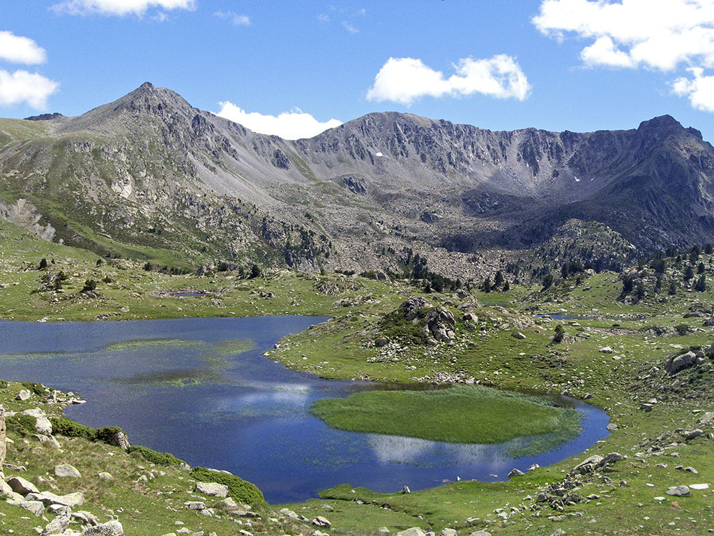
Estany Blau is one of the most picturesque lakes in Andorra. The route to this lake is challenging but rewarding, with incredible views and the possibility of spotting local wildlife. The path passes through dense forests and alpine meadows before reaching the crystal clear lake.
Tristaina Lakes Route
Difficulty: Baja
Length: 4.5 km
Unevenness: 230 m
Recommended time: June - October
This is an ideal route for families and beginners. The Tristaina Lakes are three lakes situated in a beautiful glacial cirque. The trail is relatively short and easy, but offers stunning views and the opportunity to enjoy a unique natural environment.
Route of the Pic de Comapedrosa
Difficulty: High
Length: 14 km
DesDifficulty:** High
Length: 14 km
Unevenness: 1370 m
Recommended time: June - October
The Pic de Comapedrosa, at 2,942 metres, is the highest point in Andorra. The route to the summit is demanding, with a considerable slope, but the views from the top are simply spectacular. It is a hike that requires good physical fitness and mountain experience.
Practical Advice for Trekking in Andorra
Recommended Equipment
To enjoy these routes safely and comfortably, it is essential to carry the right equipment:
- Backpack: 40-50 litres.
- Clothing: Thermal T-shirts, long and short trousers, fleece, waterproof jacket, spare socks.
- Footwear: Waterproof and comfortable boots, sandals or slippers for shelters.
- Sleeping Equipment: Sleeping bag (three or four seasons), sleeping mat and tent (optional).
- Electronics: Mobile phone, GPS, headlamp, batteries and chargers.
- Basic Needs: Toothbrush and toothpaste, soap, travel towel, sunscreen, first aid kit.
- Orientation: Map, compass, hiking apps.
- Various: Trekking poles, sunglasses, toilet paper, bags, knife, water bottle, whistle.
Accommodation
On long routes such as the GRP, you will find free and sheltered shelters, as well as hotels where you can rest. It is important to plan your stops well and take a suitable sleeping bag, as the free shelters may be busy.
Feeding
Carry enough provisions for each stage, especially on high mountain routes where there are no shops or services. Freeze-dried food and energy snacks are a good option.
Security
Always check the weather forecast before you set off and carry suitable equipment for sudden changes in weather. Inform someone of your itinerary and use hiking apps that allow you to share your location in real time.
You can enjoy hiking in the Pyrenees of Andorra. Here you will find the most impressive places in the Pyrenees of Andorra for trekking and mountaineering.
Fastpacking is not about going faster. It's about going lighter.
If you come from classic trekking, this is the next step: learning to move with less weight,
more fluid and enjoying every kilometre more.
Join the Outsiders Newsletter and start discovering what lightness feels like.