Vignemale from Bujaruelo. Ascent via the Moskowa corridor and the Lady Lyster pass and the crown route (8 three-thousanders).

This week we are going on a route to the Vignemale or Comachibosa, the massif with the most alpine character in the Pyrenees. A two-day route following the steps of the first ascensionists through the Moskowa corridor and the col of Lady Lyster, where we will crown eight 3.000m peaks: Pico Central, Montferrat, Espalda Chausenque, Punta Chausenque, Piton Carré, Pique Longue, Clot de la Hount and Cerbillona.

THE VIGNEMALE MASSIF

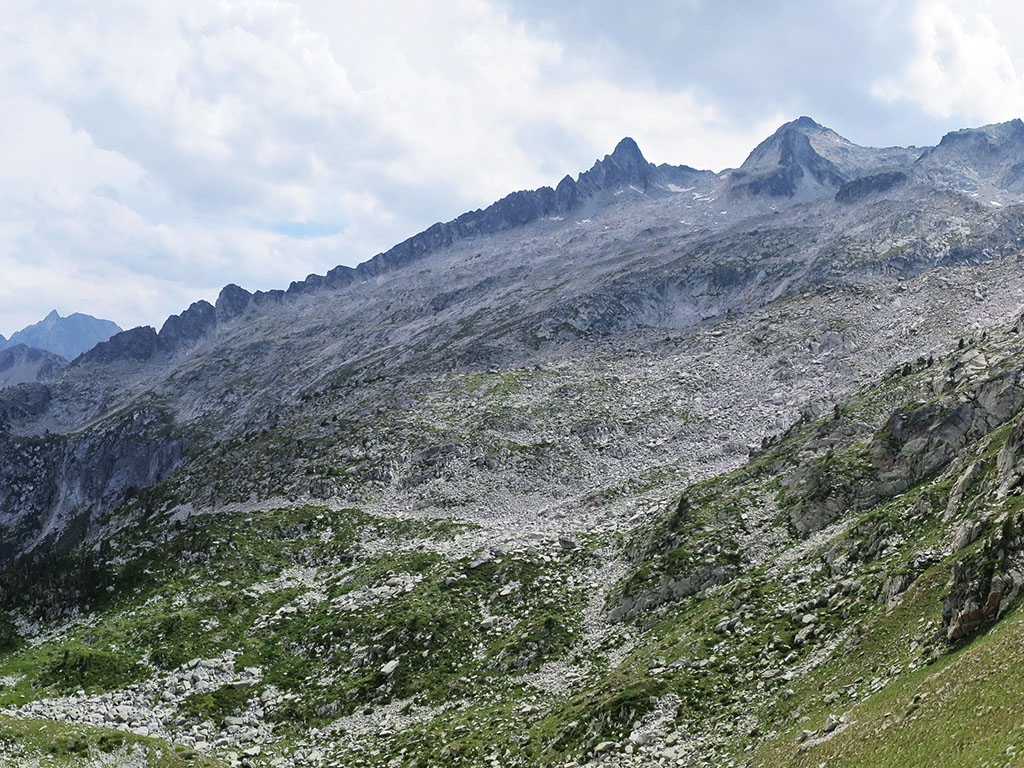
The Vignemale massif is unique in the Pyrenees. Its north face, with the Pique Longue in the centre of the wall, plunges 800 metres towards the Oulettes, and some of the most emblematic routes in the Pyrenees, such as the legendary couloir de Gaube, have been traced along its walls and corridors.

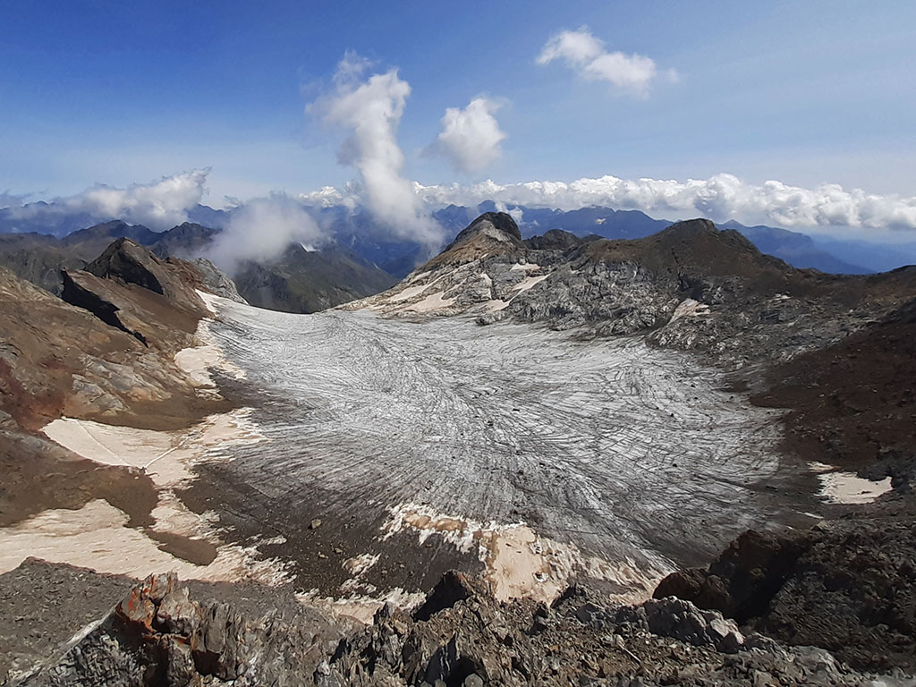
The high part forms an elegant crown of three-thousanders inside which is the Ossoue glacier, the only glacier with a tongue in the Pyrenees and the second largest (32 hectares in 2009, sixteen hectares less than in 2002). The complete route of the ridge is a must for collectors of three-thousanders. Up to 16 can be linked in a single day, as described by Miquel Capdevila in his mythical book of the 212 three-thousanders in 30 days.

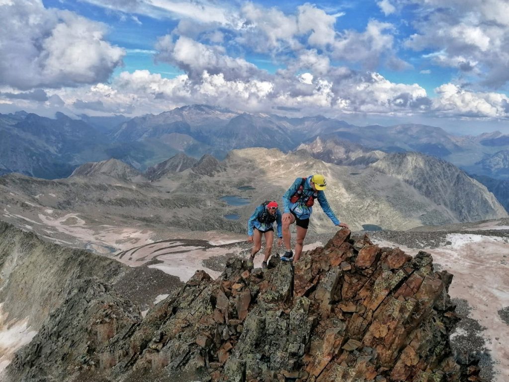
The south face, which looks impregnable, was the only place where the first ascensionists found a feasible place to climb, and it is here, along the key section of the original route, that our route runs.

SUMMARY

From the Bujaruelo refuge we will follow the GR11 up the course of the Ara to the Cerbillonar refuge, where we will spend the night. The next day we will climb up the left side of the Labaza ravine (right bank) to the Labaza snowfields to go up the Moskowa corridor and come out at the Lady Lyster pass. From here we climb to the right following the ridge to the nearby Pico Central (3,235m) and then to Montferrat (3,219m). We descend to the glacier and climb up to Espalda Chausenque (3,154m) to continue along the ridge to Punta Chausenque (3,204m) and Piton Carré (3,197m). Back on the glacier, we will climb the normal route to Pique Longue (3,298m), the highest point of the massif. Continuing along the ridge we crown Clot de la Hount (3,289m) and Cerbillona (3,247m) before reaching Lady Lister col again. The descent, by the same route, is already familiar.

MAP:

DOWNLOADABLE:

> Download Track

HOW TO GET THERE:

See in Google Maps.

Once in Torla, which can be reached on the N-260 from Fiscal (19 kms) or from Biescas (25 kms), follow the road to Ordesa to the Puente de los Navarros, where a barrier prevents unauthorised vehicles from entering the meadow during the summer months. At this point the track to Bujaruelo comes out on the left (6 kms). In total 9 kms from Torla.

Technical specifications:

Distance: 28.0kms (8.5kms on the first day and 19.5kms on the second day).
Cumulative difference in altitude: +/- 2.550m. (+580m/-110m the first day; +1970m/-2440m the second day).
Timetable: 17-18 hours. Walking time without stops: 14h25min.
Water: There are no springs along the route, although there are several streams in this predominantly livestock farming area. The best place to get water is at about 2,200 metres, in the Labaza ravine. Further up the stream disappears. Numerous streams run along the surface of the glacier, when the snow is removed and only the ice remains.
Difficulty: The route is very steep because of the distance and elevation gain, but above all because of the numerous PD/PD+ climbing pitches along the route. The Moskowa corridor, classified PD+/AD-, is easier than expected and quite safe. On the other hand, the descent of Punta Chausenque (PD), on broken terrain, is quite delicate and more complicated to descend than expected.
Recommended equipment for the summer: preferably boots, crampons, walking sticks, GPS optional, sleeping bag, sleeping mat, optional tent, etc. The ice axe is not essential as the slope is not very steep where we cross the glacier. Crampons, on the other hand, are indispensable when there is only old ice left.

ITINERARY:

DAY 1:

(0h00min; 0,0kms) Bujaruelo refuge (1.330m). At the car park at the end of the campsite, we go around the camping area, the refuge and cross the medieval bridge of San Nicolas de Bujaruelo. A sign before the bridge indicates several routes to follow in the area. Following the GR11 signs (red and white markings), we will ascend following the course of the Ara on the right side (left bank). The path crosses a meadow by the river before it comes to a track (0h25min) that you follow until you reach the GR11....

GR11 path with Pico de Ordiso and Garmo Azurillo in the background.

(1h15min; 4,7kms) Ordiso Hut (1.596m)where it ends.

Ordiso Refuge.

Continuing along the path, we cross an area of meadows where several signs warn us of the presence of livestock and the obligation to keep dogs on a leash.

Cerbillona (3,247m), Pico Central (3,235m) and Pico del Medio (3,130m).

You can't get lost on the way to the...

(2h20min; 8,5kms) Cerbillonar or Labaza hut (1.800m).

DAY 2:

(0h00min; 0,0kms) Cerbillonar / Labaza Hut (1.800m).

As soon as we start walking, we leave the bottom of the valley to start climbing to the left of the Labaza ravine (right bank).

Ara Valley.

The path is not very well marked for a normal route to the Vignemale from this slope, although it can be followed without major problems. It is a tiring path, with no rests and, to tell the truth, quite monotonous. At an altitude of about 2,200 metres, before the first rock barrier, it is a good time to take on water, as we do not see any livestock here and further up the stream disappears. Shortly after, the path makes a left turn to overcome the first rocky step and then heads off to the right (NE) towards the Labaza cirque.

Towards the Labaza cirque with Montferrat in the background.

Under the impressive Montferrat marble and next to the Labaza snowfields, relics of a splendid glacial past, we can already make out on the left the gap through which the Moskowa corridor climbs.

Circus and Labaza's marble factory.

The path turns left in the cirque of Labaza to face the strenuous rocky slope that leads to the base of the...

(2h45min; 3,3kms) Moskowa corridor (3.030m).

Moskowa corridor.

We put the poles away and begin the chimney climb (PD+/AD-) which is much easier than expected. Perhaps it is the grade of the winter corridor but the truth is that being quite generous we could classify it as PD. The corridor is divided into two chimneys, one on each side of a small gendarme on the ridge. We will go up the one on the right.

Moskowa corridor.

The climb has good foot and hand holds and is quite safe, with no feeling of emptiness, as it is protected by a wall on each side.

Moskowa corridor seen from above.

The difficulty does not end when you reach the gap and the climb continues along a wide ridge.

We leave the Moskowa corridor behind us and climb up a wide ridge.

Afterwards, you go halfway up the slope over somewhat exposed terrain where the difficulties end.

Along the ridge and halfway up the slope towards Lady Lister's col.

We can now take out the poles again to win the last stretch of the ascent to the...

(3h25min; 3,6kms) Lady Lister pass (3.200m).

Vignemale, Ossoue glacier and Central Peak from the Lady Lyster pass.

If we only intend to climb the Grand Vignemale, the easiest way is to descend directly to the glacier or after first passing the Cerbillona.

If we do not follow this route, we will start ascending on the right hand side to our first 3,000m of the day.

(3h30min; 3,7kms) Central Peak (3.235m).

At the summit of the Central Peak.

We take the opportunity to make a stop and visually trace the route we are going to take. To continue towards Montferrat, we climb up the ridge over easy terrain but where we once again have more than enough poles. The ridge becomes sharp and fun on the marble walls, although if we want to move quickly, a small path on the northern slope avoids this stretch.

The ridge up to Montferrat is one of the most spectacular sections of the route.

Just before the final ascent to Montferrat we reach a pass where we can leave the backpack (4h00min). The final stretch to Montferrat (PD-) consists of a short pass along the ridge with good rock.

(4h05min; 4,4kms) Montferrat (3.219m). Of the two peaks, the first one we come to seems to be the higher one. It is worth taking a few minutes to study the route to cross the glacier to avoid the crevasses. We return again to the pass and descend along a path that goes first to the left and then to the right. When the terrain is easy enough to go straight down to the glacier, we abandon it and go straight down.

On the Ossoue glacier, criss-crossed by numerous watercourses.

If you go in August, as when we did this route, all that remains is grey ice as hard as a rock. We put on our crampons and cross the glacier until we are below the vertical between Punta Chausenque and Espalda Chausenque. We will look for an easy route (I-II) that climbs diagonally from left to right...

Inclined ascent to Espalda Chausenque and Punta Chausenque.

up to the pass (3.147m) on the left of the...

(5h10min; 5,6kms) Back Chausenque (3.154m). We return again to the pass and continue along the ridge (I-II), which is a bit broken down and easier than it looks until we reach the...

Punta Chausenque from the Espalda Chausenque.

(5h25min; 5,8kms) Punta Chausenque (3.204m). The descent, however, is tricky, the most exposed section of this route. The descent down the face of the glacier on steep and uneven terrain is difficult. Climbing it, on the other hand, would be much easier. We pass the exit of the Y corridor and ascend Pitón Carre on steep terrain (F).

Punta Chausenque seen from the ascent to Pitón Carré.

(6h00min; 6,0kms) Piton Carré (3.197m). The descent, easier than that of Punta Chausenque, also has its own special charm.

Descending from the Piton Carré to the Gaube Gap.

We pass the exit of the famous couloir de Gaube and advance along the glacier until we are under the Pique Longue.

A look back to the Piton Carré and Punta Chausenque.

To climb the Grand Vignemale there are several alternatives of similar difficulty (F). On goat terrain, we will climb by hand on numerous occasions until we reach the...

(6h40min; 6,5kms) Pique Longue (3.298m), the highest peak in the French Pyrenees. One of the great Pyrenean giants.

Top!

The route from the ridge to the Clot de la Hount is not clear from here, we will have to get closer to discover the steps. We start by descending along the ridge that joins it with the Pique Longue. The ridge then becomes more difficult and the cairns descend the southern slope for a few metres before climbing up to the right. We leave behind a small path that climbs up to a dead end...

Dead-end gap.

and climb a few more metres to face the key pass, a wall with a crevasse running from right to left. A very pretty pass.

Compact rock at the key pass on the ascent to the Clot de la Hount.

After overcoming the most difficult section comes a stretch of loose rock, somewhat exposed if you are coming up the ridge in the opposite direction, which we will climb with caution up to the summit (PD).

(7h05min; 6,7kms) Clot de la Hount (3.289m).

Top of the Clot de la Hount.

The descent to the Cerbillona pass will be along the ridge. At first wide and then narrower. At the Cerbillona pass (7h20min), if we want to visit the Villa Russel, the first of the caves that Count Russel ordered to be built, we descend a few metres down the glacier towards the Vignemale.

Ossoue glacier on the way to the Cerbillona pass.

The ascent to Cerbillona is not difficult.

(7h30min; 7,1kms) Cerbillona (3.247m), the last of the 8 three-thousanders that we will climb on this route. A short descent takes us back to the Lady Lyster pass where we join the well-known ascent route.

(7h35min; 7,3kms) Lady Lyster pass (3.200m). The descent down to the Moskowa corridor on the steep slope requires attention but is not very difficult until the end, where we will lay our hands on the ridge at some point.

(8h00min; 7,5kms) Moskowa Corridor (3.030m). The descent of the runner is not difficult either. Taking advantage of the good grips for feet and hands, we let ourselves slip by leaning our buttocks against the slope. Once at the base of the corridor we get ready for a very long descent that will take us to the...

Descending into the Ara valley.

(9h50min; 11,0kms) Cerbillonar hut (1.800m)then along the GR11 to the...

Female roe deer on the GR11 trail.

(11h00min; 14,8kms) Ordiso Hut (1.596m) and finally, the...

(12h05min; 19,5kms) Bujaruelo Hut (1.330m).