Stage 1: Cape Higuer - Bera/Vera de Bidasoa
↔️ Distance: 31.6 km
📈 Unevenness (+830 m), (-780 m) 📉
🕒 Time: 7h30min (walking time non-stop) / xhxxmin (with stops)
⚠️ Difficulty: It is a long stage. The route is very well signposted from Irún onwards and the paths are good. It alternates between tracks, roads and some paths.
💧 Water: Throughout the stage we will find several fountains that we indicate in the text, as well as some streams, cisterns, etc.
The start of the stage is at Cape Higuer. To see in detail how to cross Hondarribia and Irun, see the foreword.
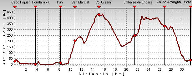
📌 (0h0min; 0kms) Cape Higuer (30m). So, from Cape Higuer we head towards Hondarribia, cross it and continue towards Irún. Once in Irún, we go up the Paseo de Colón, pass through the town hall square and go in search of Alzukaitz street. At the end of this street, just before crossing a stream (Altxuko river), take the path that heads towards San Marcial. First red and white waymarks.
📌 (2h15min; 9,2 kms) End of Irún. We continue along the pedestrian walkway, then cross the regatta and pass under the AP8 motorway. Continue to the right and then take a concrete track that starts to climb steeply uphill to the left. On the way up, you will come across the road that goes up to the...
📌 (2h45min; 10,8 kms) San Marcial Chapel (205m). In addition to the hermitage, the area has a bar, a picnic area and a couple of sources. The ascent continues along a track and then a path. During the route we pass by the Saroiaberri farmhouse - very decorated and with a beautiful garden presided over by a large olentzero - and shortly afterwards a sign will welcome us to the Aiako Harria Natural Park. We continue ascending on the way to the...
📌 (3h45min; 15,1kms) col of Erlaitz (445m) where we find the famous "Piedra del Desertor" or "Mojón de Soroeta".
It is a cairn (mugarri) on which the following inscription is engraved: "From here desertion is punishable by life". This warning was addressed to the soldiers who were stationed there in the 18th century, faced with the possibility of a French invasion, about the consequences of deserting the ranks.
This spot in the Peñas de Aia Natural Park is reached by road from Irún. It is a very popular place, and there are picnic areas and several places to make a fire in the surrounding area, although the only fountain we come across says "not suitable for drinking". The GR11 continues for approximately 1 km parallel to the road, sharing the route with the GR121 (Return to Guipúzcoa) until the Ursain pass, where it turns left and separates from the GR121. The walk continues along a comfortable, descending path in search of the...
📌 (5h00min; 21,6 kms) Endara reservoir dam (250m). We cross the dam following the road and continue along it for about 500 metres until we reach the San Antón hermitage on the right hand side. (source). On the other side of the road, next to the Olaberri farmhouse (bar-restaurant), starts the steep path along which the GR11 continues. In a few minutes we reach the...
📌 (5h30min; 23,1 kms) col of Tellería or San Antón (415m) crossed by a concrete track. At the fork, take the track on the right, shortly after which you leave the farmhouse of Tellería to the left and further on, about 700m from the pass, cross a track and continue straight on. This is a stretch with continuous ascents and descents that runs through woods, meadows and farmhouses. Continue along this path for another 700m, passing several farmhouses on the left until you leave it to take a path on the left that leads to the Gardelsoro farmhouse, where there is a watering place for the animals. A track leads to the farmhouse, which we follow until we come out onto another main track. The GR11 turns right onto the new track and then immediately leaves it along a path that goes off to the left. We join a path that runs horizontally halfway up the slope of Illasmendi (505m). We pass under a high-voltage power line and when the descent begins and the path enters the forest, we come to a small source. We continue down to the pass of...
📌 (6h30min; 26,8 kms) Alaseta/Alasta or Amargún pass (330m) on most maps. Crossing the high-voltage power line that we crossed earlier, next to a pine forest and a water tank in the shape of a farmhouse, the path forks. Straight ahead we go to Bera, and to the right we go down to Lesaka along the GR11.3. We continue to the left. After about 600m we come to a junction that is somewhat confusing due to the felling of trees (on some maps this is the Amargún pass). We continue straight on, going uphill. We leave a crossroads to the right and continue uphill, we ignore a path that descends to the left and shortly afterwards we take the next one. From now on, the markings will take us downhill until the end of this long stage in...
📌 (7h30min; 31,6 kms) Bera (35m)It is accessed by crossing the bridge of San Miguel, famous for the confrontation on 1 September 1813, during the War of Independence, between Napoleonic and English troops.


At Hondarribia there is a variety of accommodation (See accommodation).
At Irun We will find all kinds of accommodation. We recommend the Pension Gema (+34 666 172 552; eigualdeixa@hotmail.es), inexpensive and close to the train station and the GR11; the Hotel Alcazar (Tel: (+34) 943 620 490 / (+34) 943 620 900; info@hotelalcazar.com), comfortable, with a bar and just a stone's throw from the GR11, and the Hotel ETH Irun (+34 943 634 100; irun@eth-hotels.com), comfortable and with a restaurant where you can eat very well and at a good price; it is located on the banks of the river Bidasoa, next to the border and the motorway. Although you have to turn off one kilometre from the GR11, it is not necessary to go back, as you join it in San Marcial following a pretty path. See map.
At Bera we recommend the hostel-restaurant Zalain (+34 948 630 967; sainz.amaia@gmail.com).
At Berathe restaurant Zalain Jatetxea (+34 948 630 967; sainz.amaia@gmail.com), offers set menus, à la carte and takeaway.
At Hondarribia, Irún and Bera We will find all kinds of services, food shops, sports shops, bars and restaurants.
Hondarribia and Irún:
City buses from San Sebastian: ekialdebus.net
To get there by bus from anywhere: www.donostiasansebastian.com/autobuses
To arrive by train, consult routes and timetables at: Renfe, Renfe commuter trains, euskotren o SNCF (from France).
By plane, regular flights from Madrid and Barcelona to Hondarribia airport and from Biarritz (28kms), many international flights.
To reach Bera (communications with Pamplona, Irún and San Sebastian by bus), buses La Baztanesa (/) and buses La Burundesa (/).
SUA edizioak: Bidasoa Bertiz (Scale: 1/25.000)
Rando éditions: Pays basque Ouest (Scale: 1/50.000)
Essential ascent to the Peñas de Aia. Among the most popular trails are the GR121 (Tour of Guipúzcoa), the PR-GI-20 (Tour of the Peñas de Aia) and the Bidasoa Greenway (cycle touring).
Quick guide
GR 11
with everything you need to know before undertaking the Pyrenean Path