Haute Route Chamonix-Zermatt on skis
Pyrenees and mountains 📩
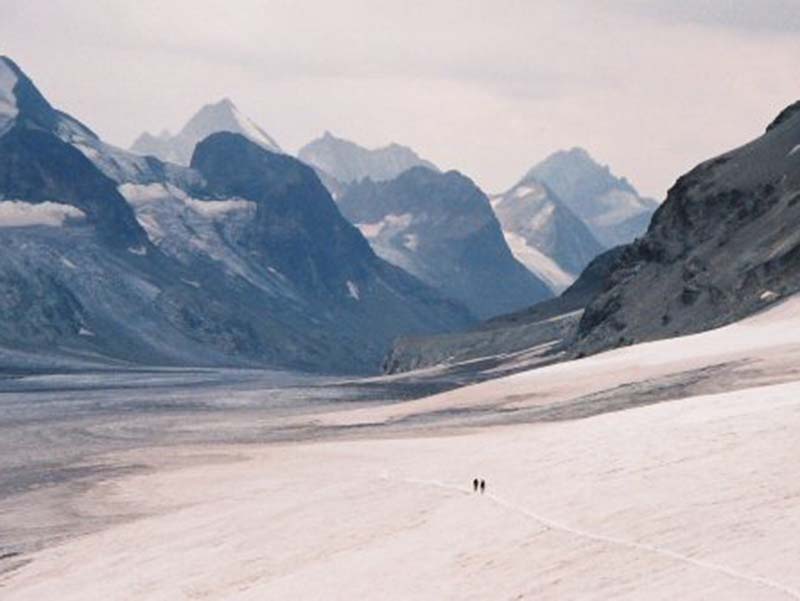
Here 🔥Talking about high altitude ski routes in the Alpsis to talk about the crossing between Chamonix (France) and Zermatt (Switzerland). This magnificent route linking these two capitals of world mountaineering is the most acclaimed and most popular among skiing and mountain lovers. This beautiful route of about 120 kilometresand some 6,000 metres of vertical drop The positive, you'll be able to see the glaciers and cols at the base of the most iconic mountains in the Alps. You'll be able to see how you approach and distance yourself from the Mont Blanc, the Matterhorn and Monte Rosaamong others. More details on this High Route will follow.
READ ALSO: Ski mountaineering in the Alps".
Advice
What you need to do before you embark on this authentic adventure is to be physically ablepsychologically and technically to make the crossing. This is not a case of going out skiing and coming home for dinner. Here you will spend six to seven days in a fully alpine environmentThe hikers are expected to sleep in shelters at high altitude, and to face great difficulties on a daily basis. It is necessary to prepare for the route well in advance. The physical preparation should be focused on the improvement of the aerobic capacityThis will enable you to endure long, steep days. There are no records to be broken, so it is preferable to train at a steady and easy pace.
In addition, technically You also need to be well prepared. It is not an adventure recommended for beginners. During the six or seven stages, the route conceals exposed sites, steep corridors, glacier walksIt would be better if you have experience in the high mountains to be able to overcome the obstacles as easily and safely as possible.
In case you are not an expert in the field, it is advisable and almost compulsory to hire a mountain guide from the International Union of Mountain Guides Associations (UIAGAM).. This professional will ensure the safety of the group, and will take the necessary decisions at all times. The price of hiring these guides is 450 to 750 euros per persondepending on the number of participants in the group.
Stages
Although the guide is in control of the group, the most common itinerary involves seven stages. However, there are variants that provide an alternative route in the event that weather conditions make it necessary to abort a stage.
The following is one of the itineraries that most mountaineers follow:
![Chamonix-Zermatt / Photo: Berria [CC BY-SA 4.0].](https://travesiapirenaica.b-cdn.net/wp-content/uploads/2018/11/Chamonix-Zermatt_zeharkaldia_by-Berria-CC-BY-SA-4.0-1024x990.png)
Stage 1: Grand Montets - Trient Hut
The first contact with the Alps can be quite tough. To cover the distance between the ski resorts and the Grand Montets and the Trient hut will take about six or seven hours. The route starts at the top of the ski resort. After descending the Agentiere glacierThe first ascent of the day towards the col de Chardonnet. Depending on the snow conditions, you will have to take off your skis and put on crampons during the ascent. The descent from the col can be done by abseiling or skiing, depending on the condition of the snow on the northern corridor leading to the Saleina glacier. A final ascent up the glacier, and you reach the Trient Hut 3,170 metres.
Stage 2: Trient Hut - Verbier - Prafleuri Hut
![Verbier Valais / Photo: Norbert Aepli, Switzerland [CC-BY-2.5].](https://travesiapirenaica.b-cdn.net/wp-content/uploads/2018/11/Verbier_Valais_by-Norbert-Aepli-Switzerland-CC-BY-2.5_800x600.jpg)
The second day is ideal for enjoying the descents. At the beginning of the stage we descend the Trient GlacierThe descent ends in the village of La Sella. The descent ends in the town of Champexwhere to catch a taxi to the ski resort of Verbier. From there, the route goes uphill until you reach the Prafleuri Hut. A journey that can take between 6 and 8 hours. However, it is possible to spend the night in the Mont Fort Hutwhich is situated before the Prafleuri Hut. In this case, the next stage would be longer.
Stage 3: Prafleuri Hut - Dix Hut
The route between the two refuges is quite short and can be done in about five hours. However, it passes through places with a high risk of avalanches, so it is worth mentioning a variant to avoid these areas. If it is known in advance that conditions will not be good, it is possible to skip the first two stages and go directly to the village of Pueblo de Arolla. From there, you can reach the Dix Hut without major problems enjoying the wonderful views of Mont Blanc de Cheilon. Because this route is short, it is a suitable day to explore nearby cols and peaks.
Stage 4: Dix hut - Vignettes hut
![Cabane des Vignettes / Photo: Jean Louis-Pitteloud [CC-BY-SA-3.0].](https://travesiapirenaica.b-cdn.net/wp-content/uploads/2018/11/Cabane_des_Vignettes_by-Jean-Louis-Pitteloud-CC-BY-SA-3.0_800x600.jpg)
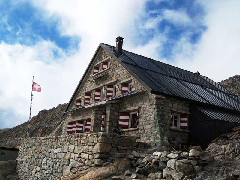
To reach the beautiful Vignettes Hut, a long and hard stage has to be covered. Although the stage begins with the descent to the plains of the Cheilon glaciersoon have to put on their sealskins, to start the ascent to the Col de la Serpentine (3,529 metres). From there, you have to walk until you reach the col of Arolla. Ten minutes from the pass, you can summit the Pigne D'Arolla which is the highest point of the entire route. The peak is situated at 3,790 metres and offers a beautiful view of the Alps. From the summit it is necessary to descend to the hut of Vignette about 600 metres of vertical drop. A descent where you can enjoy good quality snow. The refuge is one of the most spectacular in the Alps, as it is located on the edge of a precipice.
Stage 5: Vignettes hut - Bertol hut
![Cabane de Bertol / Photo: Zacharie Grossen [CC-BY-SA-3.0].](https://travesiapirenaica.b-cdn.net/wp-content/uploads/2018/11/Cabane_de_Bertol_by-Zacharie-Grossen-_CC-BY-SA-3.0_800x1000.jpg)
From the Vignettes Hut you can reach Zermatt in one day, but it is worth splitting it into two and spending the night at the Bertol Hut. The stage consists of descending to the base of the Bertol glacier and then climb up to the refuge, after 800 metres of positive ascent. The access to the refuge is unique and spectacular as you have to overcome a labyrinth of metal stairs.
Stage 6: Bertol Hut - Zermatt
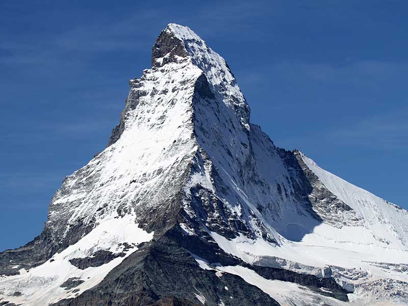
The last day can be done in about 4 to 5 hours. To make sure that the day is not too short, it is recommended to climb to the top of the Tete Blanche (3.710). The climb is easy, as it is on wide slopes. From the summit to the village of Zermatt It's all downhill. In total 18 kilometres of descent under the watchful eye of the Matterhorn.
Additional information
- The price The total cost of the trip with a hired guide can easily exceed 1,200 euros.
- It is necessary to carry technical winter equipment: Gore-texice axes, crampons, carabiners, ropes, harness, skis, boots, poles, a 50 litre backpack, thermal clothing, sleeping bag.
- The following are some of the telephone numbers that you can use to plan your journey:
Argentiere Hut: 33450531692
Trient Hut: 41277831438
Mont Fort Hut: 41277781384
Prafleuri Hut: 41272811156
Dix Hut: 41272811523
Refuge of Vignettes: 41277831322
Bertol Shelter: 41272831929
Grands Montets: 33450540082
Hotel Aiguille de la Tza, Arolla: 41272831406
Gite Alpen Rose, Chamonix: 33450537792
Fastpacking is not about going faster. It's about going lighter.
If you come from classic trekking, this is the next step: learning to move with less weight,
more fluid and enjoying every kilometre more.
Join the Outsiders Newsletter and start discovering what lightness feels like.