The GRP of Andorra: the tour of a whole country
Pyrenees and mountains 📩
Here 🔥
Quick guide TREKKING SEVERAL DAYS in the Pyrenees
with everything you need to know before undertaking a multi-stage circular route.
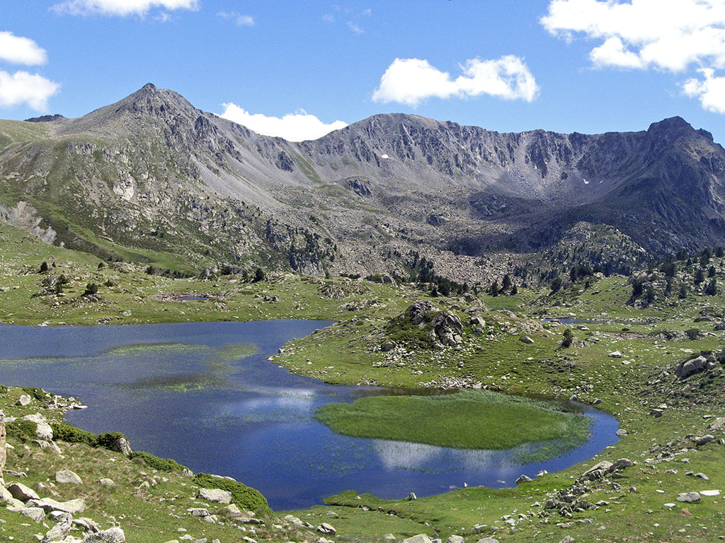
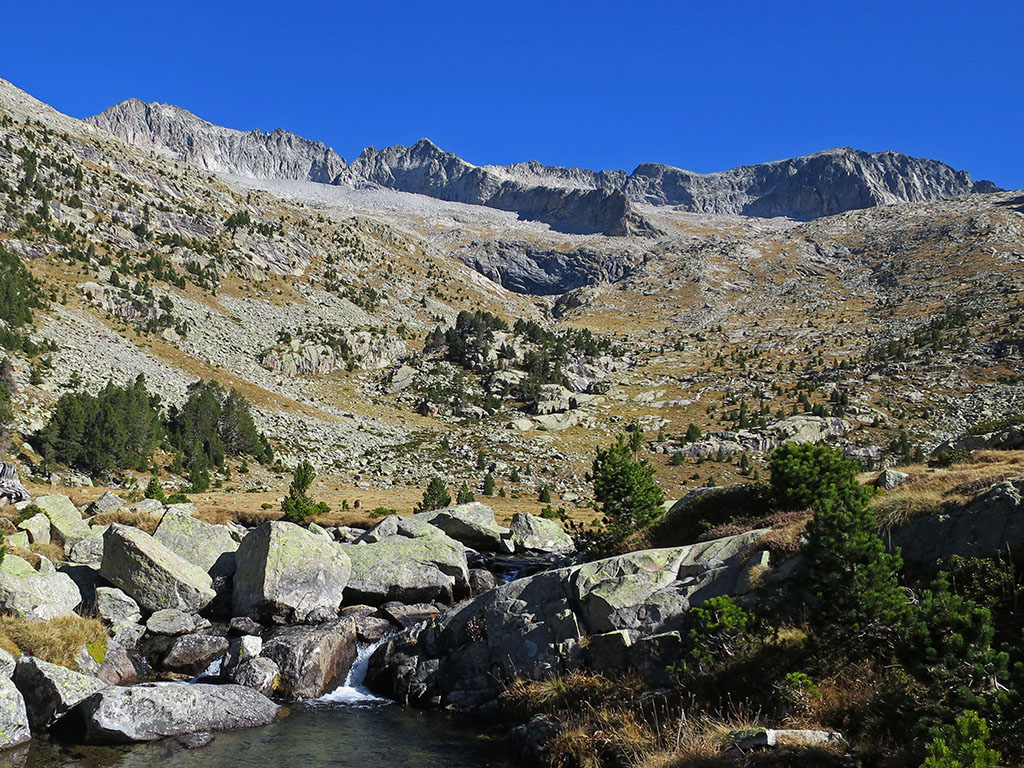
The GRP (Grand Country Route) is the return to a whole country, Andorra. A circular route of 7 stepsalmost 9,000 metres of vertical drop y 115 kilometres The route takes you through high mountain landscapes, high peaks, glacial valleys, forests and mountain villages. The best way to discover the landscapes and culture of this small country in the heart of the Pyrenees.
What is the GRP of Andorra
The GRP is a circular long-distance footpath around Andorra that is fully signposted (red and yellow). As we said, it has an approximate length of 115 kilometres and almost 9,000 metres of elevation gain, which is usually divided into 7 stages. As it is a circular route, you can start from different points and do it in one direction or the other, although, from the Principality of Andorra tourism websiteThe "official" starting point is Aixovall and the direction of travel is anti-clockwise.
Difficulty
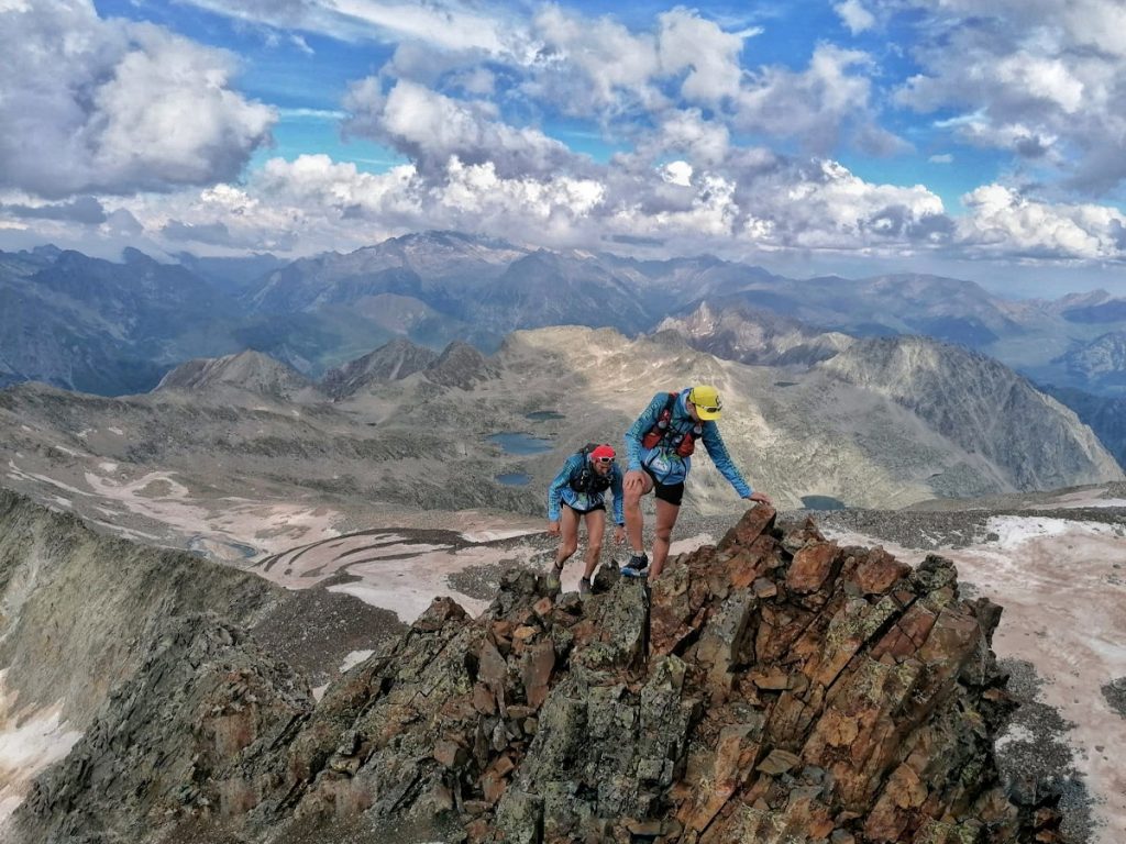
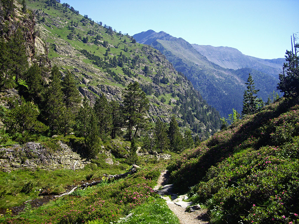
The GRP takes place in the high mountain areas of the Pyrenees, which means that you have to be prepared to walk on rough terrain, loose stones, to overcome steep slopes and to know how to find your way around in this type of terrain.
The difficulty of the stages is variable and will depend a lot on how we want to organise them, although if we follow the classical distribution, we will find two really demanding stages that exceed 20 kilometres and 2,000m of positive altitude gain.That's nothing. In terms of technical difficulty, although there are no climbing passages as such, at some specific points the path is overhead, so chains have been installed.. As in the case of the last stage, on the final descent of the Bony de la Pica.
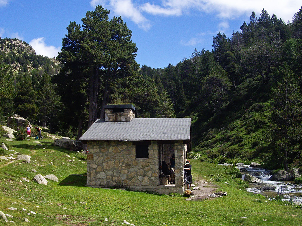
In terms of accommodation, the logistics are straightforward if the proposed layout is adhered to, since at all stage finishes, a free shelter in perfect condition, a guarded shelter or a hotel is guaranteed.. However, free shelters may be occupied by other people and it is best to make provision for this. At the end of the article there is a section on accommodation with all the free and guarded shelters that are passed on the route.
With regard to food and other goods Some things are better to carry from the beginning, as once we get into the high mountain terrain, the more populated areas will be left behind and we will only find shelters and small mountain villages with the basics.
Another factor to take into account is the meteorology. We must be alert to the formation of storms in summer and the presence of snow at the highest points until well into spring and early summer. You will pass several passes above 2,500 metres and up to 2,864 metres at the highest point of the route.
Best time to do the route
The best time to carry out the GRP is in summerwhen the highest passes are free of snow. This generally occurs from mid-June to October or November, depending on the season.
Outside these months, the mountain is completely covered with snow and the signage is hidden, and unless this is precisely what we are looking for, it is absolutely not advisable. For more information on the weather and snow conditions: http://www.meteo.ad/
Equipment needed for the route
This list can help you to prepare your backpack. It is an indicative list and it is designed to do the route in summer.
- Documentation and other essentials: ID cards, credit cards, cash, booking information, etc.
- Backpack: 40-50 litre backpack.
- Clothing / accessories: socks (2 spare pairs), underpants/briefs, 1 pair of shorts, 1 pair of long trousers, thermal T-shirt (1 spare), thin fleece, waterproof jacket, visor.
- Footwear: waterproof, lightweight boots and flip-flops or crocks for the shelters.
- To sleep: Although there are blankets in the free shelters, it is a good idea to bring a 3 or 4-season bag (depending on the weather). A tent and a sleeping mat will not be superfluous if the shelters are occupied.
- Electronics: mobile phone, camera, front, GPSbatteries and chargers.
- Toilet bag: toothbrush and toothpaste, soap, travel towel, water purification tablets, sunscreen, gauze, adhesive tape, etc.
- Orientation: ROUTE GUIDE, map, GPSmobile applications.
- Various: walking sticks, sunglassestoilet paper, bags, razor, lighter, bottlewhistle, whistle, earplugs, food, a book, etc.
Stages of the GRP of Andorra
As already mentioned in the section on difficulty, the distribution of the stages is a general proposal. It can be done in one direction or another and start at different points. Along the route there are enough shelters to plan another distribution more in accordance with our physical condition and the weather..
Remember, don't neglect planning and study the route before setting off, possible alternative routes, intermediate refuges and other stage finishers.
| Stage | Distance | Unevenness | Timetable |
| Aixovall - Claror Refuge | 21,5kms | +2276m / -924m | 9h30min |
| Claror Refuge - L'Illa Refuge | 11,1kms | +754m / -545m | 5h |
| Refuge of L'Illa - Bordes d'Envalira (Hotel Peretol) | 11,6kms | +506 / -995m | 4h30min |
| Bordes d'Envalira (Hotel Peretol) - Refuge of Juclà | 10,3kms | +994m / -689m | 4h30min |
| Juclà - El Serrat Refuge | 20,4kms | +1375m / -2232m | 8h |
| El Serrat - Comapedrosa Refuge | 19kms | +1816m / -1110m | 9h |
| Comapedrosa Hut - Aixovall | 21,2kms | +1068m / -2391m | 8h |
Itinerary
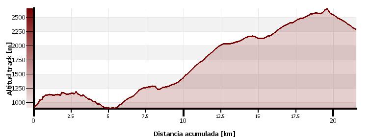
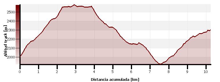
Stage 1: Aixovall - Claror Refuge
Distance: 21.5 km
Unevenness: +2276m / -924m
Timetable: 9.5 hours
Maximum altitude: 2642m
Itinerary:
This is possibly the toughest stage of the route due to the difference in altitude. The route climbs from Aixovall towards the slopes of Rocafort (right bank of the valley), flying over Sant Julià de Loria, and then descending once the village has been passed. The GRP then ascends to the other side of the valley, passing through Sant Julià de Loria. Aubinyà y Juverri on the way to the ski resort of La Rabassa, at an altitude of 2,000m. The route continues past the Roca de Pimes mountain hut towards the Pic Negre (2.642m)The highest point of this stage. A short descent brings us to the Claror's refugeThe end of this tough stage.
Stage 2: Claror Refuge - L'Illa Refuge
Distance: 11.1 km
Unevenness: +754 / -545m
Timetable: 5 hours
Maximum altitude: 2480m
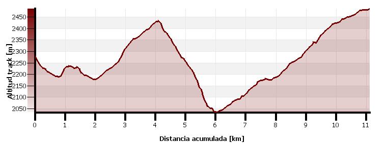
Itinerary:
The GRP continues to Nou Lake and the Perafita shelter towards the col de la Maiana (2,426m)and then descends towards the Madriú valley (Unesco World Heritage) and meet up with the GR11. The path goes up the Madriú valley passing by the refuge Riu Dels Orris and a magnificent environment of mountain lakes, such as the Bova Lake and the Rodó LakeThe end of this phase in the L'Illa sheltered refuge (2,480m).
Stage 3: L'Illa hut - Bordes d'Envalira (Hotel Peretol)
Distance: 11.6 km
Unevenness: +506m / -995m
Timetable: 4.5 hours
Maximum altitude: 2864m
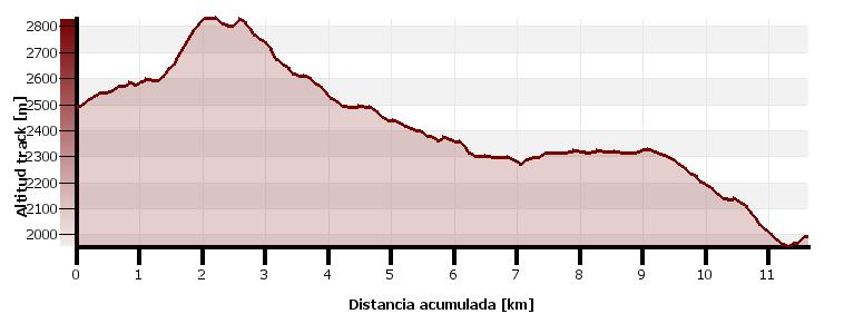
Itinerary:
The route departs from the GR11 shortly after the refuge to continue along the L'Illa Lakethe second largest in Andorra. A short ascent leaves us at the highest point of the GRP, next to the Pic dels Pessons (2864m) and which we take the opportunity to climb to the top. The path runs along the high part towards the crests of Gargantillar, up to the Pessons passwhere you leave the summits to descend towards the Pessons circusThe path goes down to the lake, a beautiful environment with the highest concentration of lakes in the country, more than 20. Estany PrimerIt continues halfway up the slope towards the north, over the Moreto forest. The stage ends descending to the valley of the Valira d'Orient where you will find the bordas de Envalirabefore passing through the refuge of the Pla de les Pedres.
Stage 4: Bordes d'Envalira (Hotel Peretol) - Juclà Hut
Distance: 10.3 km
Unevenness: +994m / -689m
Timetable: 4.5 hours
Maximum altitude: 2580m (between Collet d'Ortafà and Port Dret).
Itinerary:
The stage begins with the ascent to the Collet d'Ortafà (2,554m)This is the steepest climb of the day. Once at the top, the GRP continues to the left, crossing the Port Dret and then halfway up the slope across the Pas de les Vaqueswhere the descent starts heading north towards the Siscaró area. The path passes through the Basses del Siscaró and the Pletes del Siscarówhere the Siscaró refuge. Although the official route descends towards the bottom of the Incles valley to join the path that goes up to the Juclà Hut, this descent can be avoided if from the Pletes de Siscaró you take the path that ascends to the right and continues halfway up the slope to join the previous route one kilometre from the hut.
Stage 5: Juclà Refuge - El Serrat
Distance: 20.4 km
Unevenness: +1375m / -2232m
Timetable: 8 hours
Maximum altitude: 2713m (Meners pass).
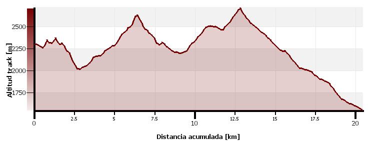
Itinerary:
A long stage that runs from east to west across the north of the country and a mountainous profile in which the metres will be accumulating in the legs. From the Juclà shelterThe GRP continues halfway up the slope in continuous ups and downs before descending to cross the Manegó River. The path continues up the sunny side of the slope on the way to the Cabana Sordanext to the Cabana Sorda Lake. To change to the Coma de Ransol valley, you still have to climb 350m, which separates you from the long ridge that rises from the Pic de la Coma de Varilles. Once at the top, the path descends steeply and then continues more gently halfway down the slope, towards the refuge of Jan's ComsThe GRP continues in the same direction in order to save the GRP. The GRP continues in the same direction in order to save the Collada dels Meners (2,713m) and descend through the valley of Sorteny (Natural Park) towards The Serrat. The descent is long, with more than 1,200 metres of vertical drop. A good option if you want to shorten this stage is to finish it at the Refugy Borda de Sorteny3 kilometres from El Serrat and 500 metres higher.
Stage 6: El Serrat - Comapedrosa Hut
Distance: 19 km
Unevenness: +1.816m / -1.110m
Timetable: 9 hours
Maximum altitude: 2581m
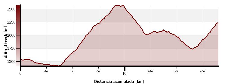
Itinerary:
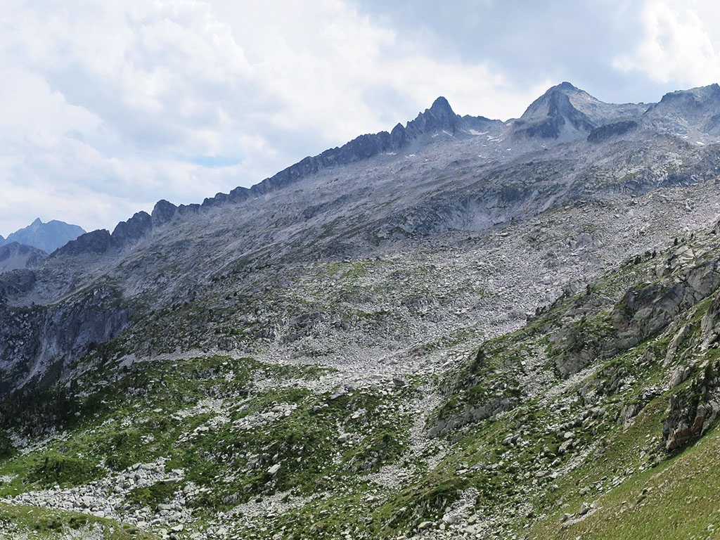
The GRP descends following the course of the Valira del Nord valley as far as the village of Llortswhere it begins a long ascent through the Angonella Valley. The trail climbs up the valley passing by the Angonella shelter and its lakes, which we leave on the right hand side, until we gain the Clot del Cavall ridge. This is the ridge that comes off to the east of the Pic de les Fonts and lies to the south of the lakes. Past the Pic del Clot del Cavall (2,586m)The trail continues towards the Pic de Percanela and then turns right and descends through the forest to the Bordes dels Prats Nous. The route continues westwards in comfort to the Pla de L'Estanywhere it changes direction (SE) and begins to descend. Shortly after the Moixó fountain the descent finishes, when the GRP rejoins the GR11 way of the Comapedrosa mountain hut.
Stage 7: Comapedrosa Hut - Aixovall:
Distance: 21.2 km
Unevenness: +1068m / -2391m
Timetable: 8 hours
Maximum altitude: 2587m

Itinerary:
The stage begins with the climb to the Portella de Sanfons (2,587m)This is the highest point of the day. Then, between chairlifts, the path skirts the peak of Port Negre and begins to descend to join a road along which we follow for half a kilometre until we reach the Coll de la Botella (2,073m). At this point it leaves to continue along a path that flanks the eastern slope of the Alt del Covil and crosses the ski slopes of the Pal ski resort. The GRP skirts the Alt del Covil to gain to the south the Muntaner pass (2,076m)where we face the last ascent of the route, passing through the Pic d'Enclar (2.383m)culminates in the Bony de la Pica (2,402m). The descent of the Bony de la Pica is probably the most technical section of the route and for safety reasons, a handrail has been installed. Be careful at this point not to stray from the route. The path enters the forest, which, passing through Aixàs and then the coll Jovelends up descending to La Marginedain the main valley of the Valira. From here it is only one kilometre to AixovallThe starting point of the route.
Practical information
Accommodation
Along the route we will find free refuges (always in good condition), shelters and also hotels with discounts for members of the GRP.
Although blankets are available in the shelters, we recommend that you bring a sleeping bag. In summer, a three- or four-season sleeping bag may be sufficient, depending on the weather on the days chosen. The free shelters may be busy. Try not to arrive too late assuming that at the end of the day there will be a mattress, blankets and a roof waiting for you.
We recommend you get the Refuge Passport in any Andorra Tourist Officeis free of charge. With this document you will be able to justify the different stages of the itinerary and at the end, you will get a diploma of accreditation of the route.
Stage 1: Aixovall - Claror Refuge:
- Roca de Pimes Hut: free standing, 6 seats, fireplace.
- Claror Shelter: free, 20 seats, water nearby, fireplace.
Stage 2: Claror Hut - L'Illa Hut:
- Refuge of Perafita: free, sleeps 6, water nearby, fireplace.
- Riu dels Orris Refuge: free, sleeps 6, water nearby, fireplace.
- Shelter dand L'Illa: storage, 50 places, bar service, etc.
Stage 3: Refuge of L'Illa - Bordes d'Envalira (Hotel Peretol):
- Pla de les Pedres hut: free, 6 places.
- In the The Envalira mountain ridge: Hotel Peretol (GRP special conditions), see more accommodation.
Stage 4: Bordes d'Envalira (Hotel Peretol) - Juclà Hut:
- Cabaña de Siscaró Hut: free, 10 seats, fountain, fireplace.
- Juclà Refuge: storage, 43 seats, bar service, etc.
Stage 5: Juclà Refuge - El Serrat:
- Cabana Sorda hut: free, 20 seats, fireplace.
- Refuge Cóms de Jan: free, 10 seats, fountain, fireplace.
- Borda de Sorteny Hut: storage, 40 seats, bar service, etc.
- The Serrat: see accommodation.
Stage 6: El Serrat - Comapedrosa Hut:
- Angonella hut: free, sleeps 6, water nearby, fireplace.
- Fonts Refuge: free, sleeps 6, water nearby, fireplace.
- Pla de l'Estany Refuge: free, 6 seats, fountain, fireplace.
- Comapedrosa Hut: storage, 49 seats, bar service, etc.
Stage 7: Comapedrosa Hut - Aixovall
- In Aixovall: see accommodation.
Bibliography / maps:
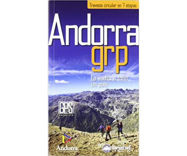
Andorra grp: circular route in 7 stages.
- Editorial: Ediciones Desnivel S.L
- Language: English
- No. of pages: 96
- ISBN-10 : 8498292425
- ISBN-13 : 978-8498292428
- Publication: 2012
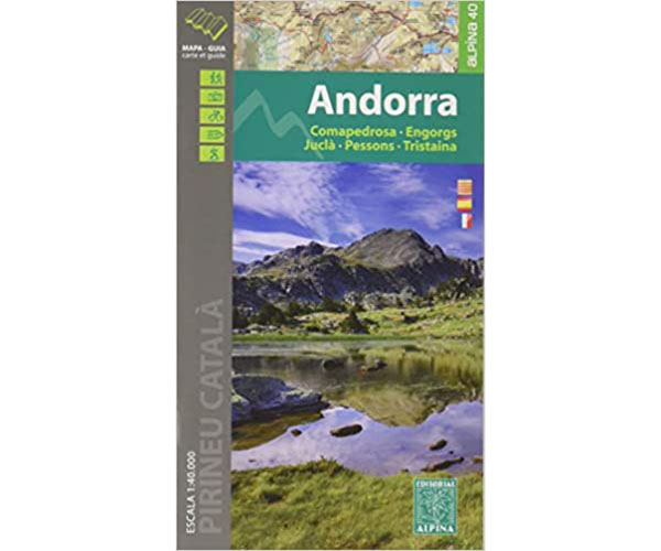
- Editorial: Editorial Alpina S.L
- Scale: 1:40.000
- ISBN-10 : 8480906626
- ISBN-13 : 978-8480906623
- Publication: 2016
Climatology:
All the information about the weather forecast and the snow report in: https://www.meteo.ad/
Emergency telephones:
- Emergencies: 112
- Medical emergencies: 116
- Police: 110
- Fire brigade: 118
You may be interested in:
Fastpacking is not about going faster. It's about going lighter.
If you come from classic trekking, this is the next step: learning to move with less weight,
more fluid and enjoying every kilometre more.
Join the Outsiders Newsletter and start discovering what lightness feels like.
A great experience the transpirena on foot !!!v