Excursion to the circular lake of Bernatuara
![Ibón de Bernatuara_ / Photo: Babylas [CC BY-SA 3.0] Wikimedia Commons](https://travesiapirenaica.b-cdn.net/wp-content/uploads/2017/10/ibón-de-Bernatuara_-by-Babylas-CC-BY-SA-3.0-Wikimedia-Commons_1200x900.jpg)
Pyrenees and mountains 📩
Here 🔥The excursion we propose today will take us to the Bernatuara lakelocated at an altitude of 2,335 metres, in a route that lasts about three hours. This is a high mountain excursion, with a demanding route and a difference in altitude of 970 metres, so it is not recommended for beginners or children.


From San Nicolás de Bujaruelo to the Ibón and Bernatuara Peak
We set off from the refuge of San Nicolás de Bujarueloat an altitude of 1,338 metres. The refuge can be reached via Torla, taking the A-135 towards the north, in the direction of Ordesa y Monte Perdido National Park, and travelling two kilometres to Puente de los Navarros, from where the 6 km track leads to the refuge.
On leaving the refuge we cross the bridge and take the GR path that heads towards the pass of Bujaruelo. After about 45 minutes' walk, once we have passed 1,500 m, next to an electricity pylon, we will find the turning to the left that will take us to the lake - it is indicated with a yellow arrow. We continue along a path that runs parallel to the Lapazosa ravine.
We cross the ravine at the height of the little iron bridge, which is now useless as it has been torn out by the raging waters. It may be necessary to take off your shoes to avoid getting your boots and clothes wet. Once on the other side, and after crossing a small beech We will arrive at the Plana de Sandaruelo refuge (1,680 m).
We then climb up a short but steep slope, before moving on to a gentler section. After a brief stop to recharge our batteries, we face the final demanding climb under the gaze of the peaks of the Bernatuara y Crapera.
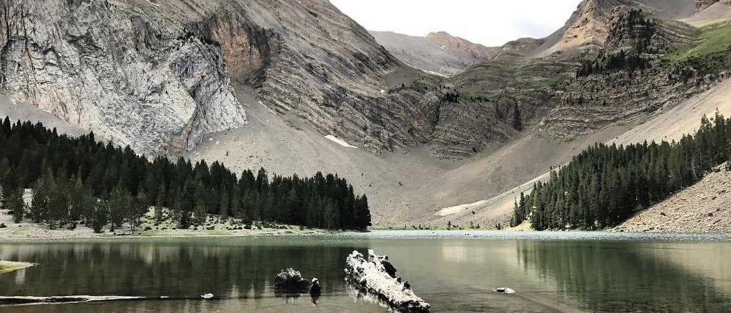
Once at the top, the path turns to the right and heads horizontally towards a pass, under which the surprising Ibón de Bernatuara appears. The Ibón suddenly appears before your eyes, with its crystal-clear, greenish waters. It is large and round in shape, almost a perfect circle..
Bernatuara Peak.
We continue along the left hand side, the path continues to Puerto de Bernatuara (2338m). From here we can climb Pico Bernatuara (2516m) to the left (west). We return along the same route.
A CIRCULAR alternative is from the Bernatuara pass to access the Ara valley and return along the GR11 back to the Refugio de Bujaruelo.
Fastpacking is not about going faster. It's about going lighter.
If you come from classic trekking, this is the next step: learning to move with less weight,
more fluid and enjoying every kilometre more.
Join the Outsiders Newsletter and start discovering what lightness feels like.