Download the track


WARNING: the section between Estanés lake and Candanchú has been discontinued. The new stretch of the route adds another day to the walk. From Estanés lake the route heads towards Lizara via valle de los Sarrios, Bernera bridge and Plana Mistresa. From Lizara you can take the variant GR11.1 or continue along the new stretch: Lizara-Collado del Bozo-Collado de Esper-Tuca Blanca-Tobazo-Candanchú.

Stage 10 (discontinued): Aguas Tuertas - Candanchú
Alternative - Main Route: Aguas Tuertas - Ref. Lizara


Distance/elevation: 14,3 km / (+530),(-600)
Time: 4h30min (walking time without stops).
Difficulty: This stage has been discontinued and around Estanés lake the red and white markings disappear. Take particular care after Estanés lake to take the path to Candachú. You are recommended to avoid the Chorrota de Aspe section if there is a risk of landslide.
Water: Throughout the stage you will find a good number of streams. Avoid taking water where the presence of livestock is evident.
Route/Itinerary:

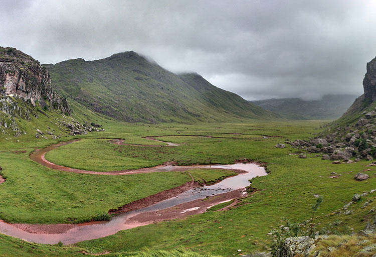
(0h0min; 0kms) Aguas Tuertas (1,620m). The valley in Aguas Tuertas is undoubtedly one of the most picturesque in the whole of the Pyrenees. The river zigzags drawing impossible meanders across an idyllic meadow surrounded by mountains. It is a place that exudes an incomparable sense of peace and serenity. The path heads towards the head of the valley on the left-hand side, where water flows from Barranco de la Rueda. Shortly before, the path turns left (east) and looks for a good place to cross the river (not always easy), on the way to...

(0h50min; 2.9kms) Escalé Pass (1,660m). A signpost signals left to Escalé pass and right to Estanés lake (GR11). You head on up to a col.

(1h35min; 4.8kms) Toronez d'as Cabretas (1,910m). Then take a short descent. Keep a keen eye on waymarking – especially in foggy conditions – so as to avoid walking down to the lake, because you need to skirt round it half-way up in order to avoid the walls that surround it on this side.

(2h05min; 6kms) Ibón de Estanés (crossing) (1,806m). Signpost. The new section of the GR11 no longer goes down to Estanés lake. Instead, it continues towards Lizara mountain refuge across the Valle de los Sarrios. At this point, you ignore the red and white markings and continue along a marked path (green and yellow, belonging to the Camille Trail) that heads towards the lake shore. You leave it to the left and head towards...

(2h25min; 7.2kms) Puerto de Estanés (1,792m), to the east of the lake. Before that you will pass a stream The trail – clearly marked – coincides with other walks that drop down towards the car park at Sansanet, in France. On the descent, 1.4 kilometres from Estanés pass, you need to take care not to miss a path that takes a sharp right turn (Camille Trail). The crossing comes shortly after crossing the stream that you have been following, after a short rise. The path starts out on the hillside, revealing magnificent vistas over the peaks that stand proud above the Aspe valley.

(3h00min; 9.6kms) Frontier - Bosque de Sansanet (1,607m). Just before entering Sansanet forest (Parc National des Pyrénées), you cross over a perfect stream for taking on water. The path continues steadily along the hillside, towards Chorrota de Aspe, where you leave the shelter of the woods, and soon afterwards pass a section where a landslide forced the path to be diverted. Further on, the path passes through another section of woodland. On the way out, you come to a little stream and shortly afterwards, a drinking fountain. Just a short climb awaits up to Causiat pass (1,630m), a border post with ski slopes, followed by a gentle descent to Candanchú.

(4h30min; 14.3kms) Candanchú (1,550m).

Where to sleep:

At the beginning of the Aguas Tuertas Valley, you will find the Aguas Tuertas cabin (free, in good condition, basic).

In Candanchú a number of auberges and hotels are open, depending on the time of year. We recommend: Apartamentos Candanchu 3000 (Tel: +34 976 10 13 32; booking@apartamentos3000.com) and Albergue Aysa (Tel: +34 974 373 023; aysa.somport@gmail.com), in Somport (1km).

Transport:

Between Candanchú and Jaca, there is a regular line on the Mancomunidad Alto valle del Aragón local route. You will find information on timetables on the Comarca de la Jacetania website.


Perfil de la etapa


Stages - GR11

- Prologue: Cabo Higuer - Hondarribia - Irun
- Stage 1: Cabo Higuer - Bera
- Stage 1v (GR 11.3): Cabo Higuer - Lesaka
- Stage 2: Bera - Elizondo
- Stage 2v (GR 11.3): Lesaka - Elizondo
- Stage 3: Elizondo - Pto de Urkiaga
- Stage 4: Puerto de Urkiaga - Burguete
- Stage 5: Burguete/Auritz - Villanueva de Aezcoa/Hiriberri
Stage 6: Villanueva de Aezcoa/Hiriberri - Ochagavia
Stage 7: Ochagavia - Isaba
Stage 8: Isaba - Zuriza (via Belabarce)
Stage 8v (GR 11.4): Isaba - Zuriza (via Ezkaurre)
Stage 9: Zuriza - Aguas Tuertas
Stage 10: Aguas Tuertas - Lizara
Stage 10 (discontinued): Aguas Tuertas - Candanchú
Stage 11: Lizara - Candanchú
Stage 12: Candanchú - Sallent de Gallego
Stage 9v (GR 11.1): Zuriza - Puente de Santa Ana
Stage 10v (GR 11.1): Puente de Santa Ana - Lizara
Stage 11v (GR 11.1): Lizara - Canfranc Estación
Stage 12v: Canfranc Estación - Sallent de Gallego (via C.Izas)
Stage 13: Sallent de Gallego - Refugio de Respomuso
Stage 14: Refugio de Respomuso - Balneario de Panticosa
Shortcut: The pipeline path from Bachimaña to Brazato
Stage 15: Balneario de Panticosa - San Nicolas de Bujaruelo
Stage 16: San Nicolas de Bujaruelo - Refugio de Goriz
Stage 17: Refugio de Goriz - Circo de Pineta (Fuenblanca)
Stage 17v (GR11.9): Refugio de Goriz - Circo de Pineta (Faja de las Olas)
Stage 18: Circo de Pineta - Parzán
Stage 19: Parzán - Biadós
Stage 20: Biadós - Puente de San Jaime
Stage 20v (GR 11.2): Biadós - Ref. Ángel Orús
Stage 21v (GR 11.2): Ref. Ángel Orús - Puente de San Jaime
Stage 21: Puente de San Jaime - Refugio de Cap de Llauset
Stage 21v (GR 11.5): Puente de San Jaime - Refugio de la Renclusa
Stage 22v (GR 11.5): Refugio de la Renclusa - Refugio de Cap de Llauset
Stage 22: Ref. Cap de LLauset - Conangles
Stage 23: Conangles - La Restanca
Stage 24v (GR11.18): La Restanca - Colomers
Stage 25: Colomers - Ernest Mallafré
Stage 26: Ernest Mallafré - La Guingueta
Stage 27: La Guingueta - Estaón
Stage 28: Estaón - Tavascán
Stage 29: Tavascán - Areu
Stage 30: Areu - Baiau
Stage 31: Baiau - Arans
Stage 32: Arans - Encamp
Stage 33: Encamp - Ref. l'Illa
Stage 34: Ref. l'Illa - Malniu
Stage 35: Malniu - Puigcerdá
Stage 36: Puigcerdá - Planoles
Stage 37: Planoles - Santuario de Nuria
Stage 38: Santuario de Nuria - Refugio de Ulldeter
Stage 39: Refugio de Ulldeter - Molló
Stage 40: Molló - Talaixà
Stage 41: Talaixà - Albanyà
Stage 42: Albanyà - La Vajol
Stage 43: La Vajol - Requessens
Stage 44: Requessens - Vilamaniscle
Stage 45: Vilamaniscle - El Port de la Selva
Stage 46: El Port de la Selva - Cap de Creus


Map of the stage


info@travesiapirenaica.com