Stage 21 (GR11.5): Puente de San Jaime - Refugio de la Renclusa


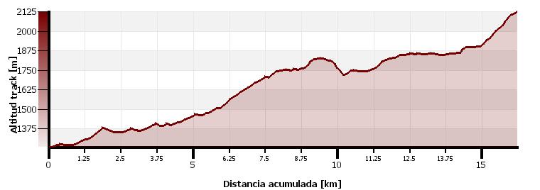
(0h00min; 0kms) Puente nuevo de San Jaime (1,254m). It is 3kms from here to Benasque. Take the track that follows the left flank of the river Ésera. The track runs alongside the river to the Paso Nuevo reservoir. At the tail of the reservoir, just before Plan de Senarta, is the crossing where the variant GR11.5 (ahead) peels off from the main route (right). In 3 minutes you reach the...
(0h45min; 3.0kms) Plan de Senarta (1,362m). Car park and controlled camping area (1 Jul – 30 Sept). Follow the track up the valley. After 200m you pass a crossing (right). The track heads into a mixed forest of fir, boxwood, hazelnut and birch trees among other species. Shortly before entering the valley of Cregüeña, there is a bridge and a path to the lake (3h30min), and you also pass San Farré drinking fountain.
(1h30min; 5.2kms) Puente de Cregüeña (1,465m). The track continues along the right flank to the Puente de los Baños (13 minutes). Without crossing the bridge, you follow the river and come to a free shelter and a drinking fountain. Cross the bridge and follow the path uphill to the Baños de Benasque road. Beforehand you will cross a couple of streams. Continue along the road to the...
(2h05min; 7.0kms) Baños de Benasque (1,660m). Spa, hotel and bar (only in summer). Just before reaching the Baths you take a path to the left towards the Hospital de Benasque. In 8 minutes you pass a crossing that heads up to the Pico de Alba and a river that may well be dry. Further ahead you pass another stream (25 minutos from the Baths). You head up a kind of pass then begin the descent to the Llanos del Hospital road. Follow the road to the right, or head down to the river and continue along a path to the nearby...
(3h25min; 10.6kms) Hospital de Benasque (1,750m). A left-hand fork brings you to La Besurta crossing the Llanos del Hospital. After half a kilometre you cross a stream via a little wooden bridge called a “palanca”. Soon afterwards, the path to the Portillón de Benasque emerges on the left. The path zigzags its way up to Pleta del Tormo, passes Colladeta dels Aranesos and comes out at Plan d'Estan, where you rejoin the rickety road the goes up to Besurta. The GR11 crosses the road and, after 15 minutes, reaches...
(4h35min; 14.5kms) La Besurta (1,897m). Small car park, bar and toilets. In summer, a bus service from Benasque runs up to this point. You pass a small bridge over a stream. In 12 minutes you reach a crossing which, straight ahead, leads to Forau d'Aigualluts. If you are not going to spend the night in Renclusa, you continue straight ahead. Otherwise, take the path to the right that in half an hour takes you up to the...
(5h15min; 16.2kms) Refugio de la Renclusa (2,140m).
At the beginning of the stage Camping Aneto, Camping Ixeia and Hostal Parque Natural.
In Benasque, 3km away from the route, you will find a choice of accommodation. We recommend Hotel San Antón (Tel: +34 974 55 16 11; info@hotelsananton.es) and Hotel Aragüells (Tel: +34 974 55 16 19; info@hotelaraguells.com), both with restaurant.
During the stage, at Plan de Senarta there is an area of controlled camping belonging to the Benasque Town Council (from 1 July to the 30 September). Without crossing the river at Baños de Banasque, just 200m upstream, you reach a free fishing shelter (acceptable condition, with fireplace, 2 rooms for 12 and 10 people). If you continue towards Forau de Aigualluts, there is a cabin in a rather precarious state.
At the end of the stage, Refugio de la Renclusa (/).
Other services:Both Camping Ixeia and Camping Aneto have a supermarket where you can get basic provisions. In Benasque you can find all kinds of amenities: outdoor pursuits stores, a supermarket, ATM, bars and restaurants, etc.
Maps:
Alpina:
Parque Natural Posets Maladeta
(Scale: 1/25,000)
Valle de Benasque. Aneto, Maladeta, Posets, Perdiguero
(Scale: 1/40,000)
Aneto-Maladeta
(Scale: 1/25,000)
Vall de Barravés Ribagorça
(Scale: 1/25,000)
Prames:
Aneto-Maladeta
(Scale: 1/25,000)
SUA:
Maladeta-Aneto
