Download the track


Stage 38: Santuario de Nuria - Refugio de Ulldeter
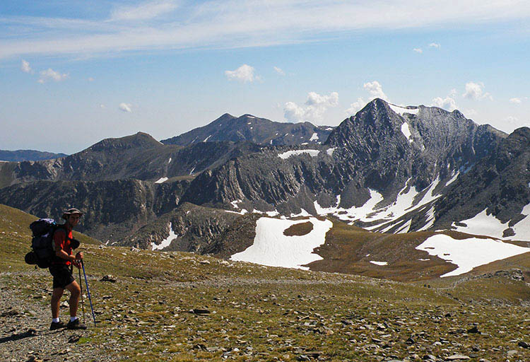

Distance/elevation: 11,6 kms / (+1.000),(-720)
Time: 5h00min (walking time without stops).
Difficulty: an ice axe and crampons could be necessary in snow.
Water: there are several streams along the way, so no problem.
Suggestions: you can make the stage longer by walking on to Setcases (8km;2h40min). Another option is, once you are at the Pic Superior de la Vaca, instead of following the waymarked itinerary, you could easily continue along the ridge of the Pic Inferior de la Vaca (2,820m), the Pic de l'Infern (2,869m) and the Bastiments (2,883m), to later rejoin the GR11 at the Coll de la Marrana.

Route/Itinerary:

(0h00min; 0 kms) Santuario de Nuria (1.967m). Walk round the back of the temple, pass a meteorological observatory and cross a small bridge over the Noufonts torrent. You head right, to join the track rising up the valley, that leads to the Noucreus and Noufonts cols. The track gives way to a path and you soon see the spot where the Noucreus and Noufonts torrents converge. Cross Noucreus torrent via the Pont de L'Escuder bridge and you will quickly come to a crossing.

(0h40min; 1,8 kms) Cruce Noucreus-Noufonts (2.180m). Although in many (older) publications the GR11 route is still indicated as passing through Noufonts, in current times the red and white markings direct you to Noucreus col, a quicker and more direct option. Keep climbing the path to the right that heads up through Noucreus valley passing La Coma de les Molleres and La Coma de Noucreus. Towards the end of this section, the climb gets steeper, you reach the col with panoramic views and turn left in order to reach Noucreus col in about 5-10 minutes.

(2h15min; 4,8 kms) Collado de Noucreus (2.790m). You join the ARP route (unmarked). From this point, the walk follows the ridge that marks the frontier, between peaks of around 2,800m. Pass the Pic de la Fossa del Gegant (2,808m) by the north face and drop down to Carança col (2,726m), then continue up to Pic Inferior de la Vaca (2,826m), past Coll de la Vaca (2,793m) and leave the Pic Superior de la Vaca (2,820m) on the left, to continue along the border ridge to...

(3h05min; 6,6 kms) Collado de Tirapits (2.775m). Turn left (north-west) and begin the descent. After 10 minutes you pass Barraca de Tirapits shelter (only in case of extreme necessity). Continue down through the valley, leaving the Torrent de Les Barraques on the right, until, in a relatively flat area, you rejoin the GR11.7 variant coming from Nuria. At this point you cross a stream that appears on the left, and start the climb to the...

(4h15min; 10,1 kms) Collado de la Marrana (2.524m). Wide open view. The walk drops sharply through the small cirque, then you continue your descent across the valley floor, crossing a ski piste, until you reach the...

(5h00min; 11,6 kms) Refugio de Ulldeter (2.220m).

Where to sleep:

At the beginning of the stage you have the Refugio-Albergue Pic de l'Àliga and the Hotel Vall de Nuria. There is also a controlled camping area ()

During the stage you will pass by the Barraca de Tirapits shelter. This is not really an option – only in case of extreme necessity.

At the end of the stage, Refugio de Ulldeter (/).
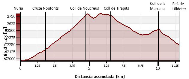

Perfil de la etapa

Stages - GR11

- Prologue: Cabo Higuer - Hondarribia - Irun
- Stage 1: Cabo Higuer - Bera
- Stage 1v (GR 11.3): Cabo Higuer - Lesaka
- Stage 2: Bera - Elizondo
- Stage 2v (GR 11.3): Lesaka - Elizondo
- Stage 3: Elizondo - Pto de Urkiaga
- Stage 4: Puerto de Urkiaga - Burguete
- Stage 5: Burguete/Auritz - Villanueva de Aezcoa/Hiriberri
Stage 6: Villanueva de Aezcoa/Hiriberri - Ochagavia
Stage 7: Ochagavia - Isaba
Stage 8: Isaba - Zuriza (via Belabarce)
Stage 8v (GR 11.4): Isaba - Zuriza (via Ezkaurre)
Stage 9: Zuriza - Aguas Tuertas
Stage 10: Aguas Tuertas - Lizara
Stage 10 (discontinued): Aguas Tuertas - Candanchú
Stage 11: Lizara - Candanchú
Stage 12: Candanchú - Sallent de Gallego
Stage 9v (GR 11.1): Zuriza - Puente de Santa Ana
Stage 10v (GR 11.1): Puente de Santa Ana - Lizara
Stage 11v (GR 11.1): Lizara - Canfranc Estación
Stage 12v: Canfranc Estación - Sallent de Gallego (via C.Izas)
Stage 13: Sallent de Gallego - Refugio de Respomuso
Stage 14: Refugio de Respomuso - Balneario de Panticosa
Shortcut: The pipeline path from Bachimaña to Brazato
Stage 15: Balneario de Panticosa - San Nicolas de Bujaruelo
Stage 16: San Nicolas de Bujaruelo - Refugio de Goriz
Stage 17: Refugio de Goriz - Circo de Pineta (Fuenblanca)
Stage 17v (GR11.9): Refugio de Goriz - Circo de Pineta (Faja de las Olas)
Stage 18: Circo de Pineta - Parzán
Stage 19: Parzán - Biadós
Stage 20: Biadós - Puente de San Jaime
Stage 20v (GR 11.2): Biadós - Ref. Ángel Orús
Stage 21v (GR 11.2): Ref. Ángel Orús - Puente de San Jaime
Stage 21: Puente de San Jaime - Refugio de Cap de Llauset
Stage 21v (GR 11.5): Puente de San Jaime - Refugio de la Renclusa
Stage 22v (GR 11.5): Refugio de la Renclusa - Refugio de Cap de Llauset
Stage 22: Ref. Cap de LLauset - Conangles
Stage 23: Conangles - La Restanca
Stage 24v (GR11.18): La Restanca - Colomers
Stage 25: Colomers - Ernest Mallafré
Stage 26: Ernest Mallafré - La Guingueta
Stage 27: La Guingueta - Estaón
Stage 28: Estaón - Tavascán
Stage 29: Tavascán - Areu
Stage 30: Areu - Baiau
Stage 31: Baiau - Arans
Stage 32: Arans - Encamp
Stage 33: Encamp - Ref. l'Illa
Stage 34: Ref. l'Illa - Malniu
Stage 35: Malniu - Puigcerdá
Stage 36: Puigcerdá - Planoles
Stage 37: Planoles - Santuario de Nuria
Stage 38: Santuario de Nuria - Refugio de Ulldeter
Stage 39: Refugio de Ulldeter - Molló
Stage 40: Molló - Talaixà
Stage 41: Talaixà - Albanyà
Stage 42: Albanyà - La Vajol
Stage 43: La Vajol - Requessens
Stage 44: Requessens - Vilamaniscle
Stage 45: Vilamaniscle - El Port de la Selva
Stage 46: El Port de la Selva - Cap de Creus


Selección: Piolets
Petzl
Glacier Literide
320grs (50cms)
Grivel
Nepal S.A.
440grs (58 cm)
Salewa
Tour-X Pro
470grs (55cms)


Map of the stage


info@travesiapirenaica.com