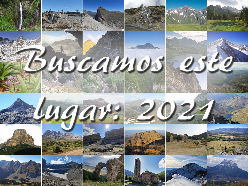
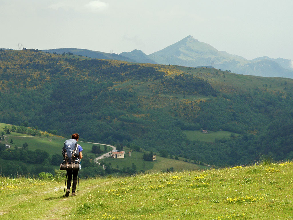
We are looking for this place: 2021
Pyrenees and mountains 📩
Here 🔥Happy New Year, Pyrenees lovers! As you know, during 2021 we set you the challenge of finding a place in the Pyrenees every week. The solution, as always, can be found in the weekly newsletter that we share with you on Thursdays.
This year, without serving as a precedent, we begin with a compilation of all those places that we proposed you to find in 2021.
In addition, as a new feature for 2022, we encourage you to be the ones to propose the place. At the end of the article we leave you a form where you can you can send us your pictures together with the clues and the solution.. Each week we will choose one of the photographs received for publication (CLICK HERE).
And without further ado, these are the 40 places for 2021.
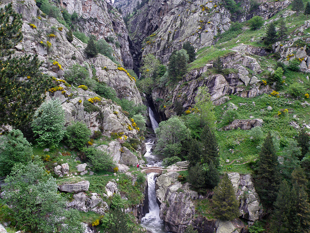
We are looking for this place #1:
The greenery of the French Pyrenees is marvellous. Damp forests, lush vegetation and plenty of water, like this waterfall that we have come to visit today. Do you know which place it is?
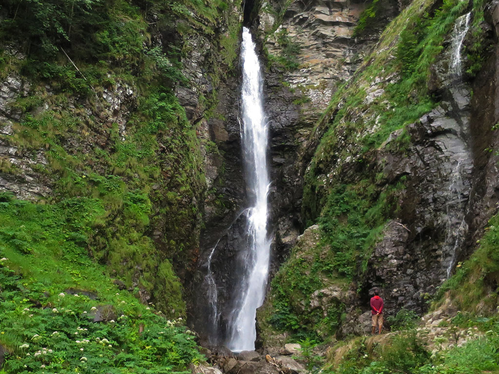
Tracks:
- It is located in the French Pyrenees.
- It is a five-minute walk to get there, suitable for children.
Solution:
The Cascade d'Enfer is a beautiful waterfall near Bagneres-de-Luchon (11kms) which can be reached on foot in a few minutes. In addition, there are several signposted walks in the area which are well worth doing, perfect for a day out.
We are looking for this place #2:
This time we have taken you to the Catalan Pyrenees, to a well-known place where any Pyrenean climber from this land has surely been at some point. But do you know which place it is?
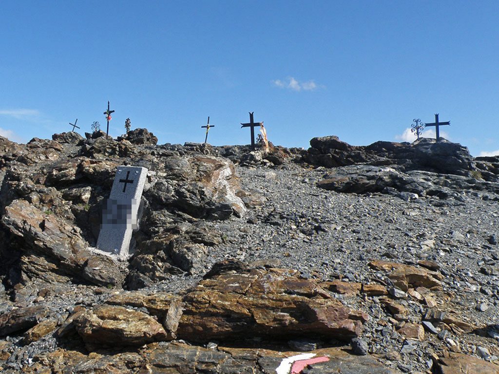
Tracks:
- It is located in the Catalan Pyrenees.
- This is one of the highest points along the GR11.
- This is the location of the boundary stone (xxx), which we have blurred in the photograph.
Solution:
The Noucreus passone of the highest passes that crosses the GR11and which links Nuria with the Ulldeter refuge. There is a boundary marker 510 and 9 iron crosses in memory of a group of skiers who died in the 19th century as a result of the Torb, as this meteorological phenomenon caused by the combination of snow on the surface and hurricane-force winds is known here.
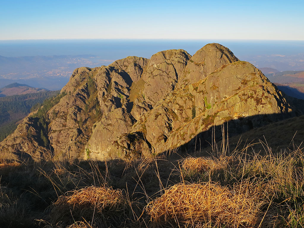
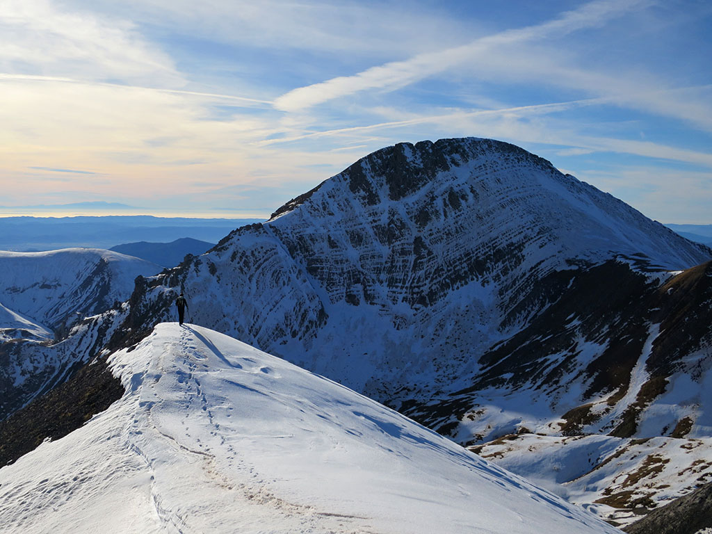
We are looking for this place #3
We are in the Aragonese Pyrenees, do you know which is the peak that appears in the image? Where is it taken from? In the background there is a good clue if you know to which mountain those marble quarries belong.
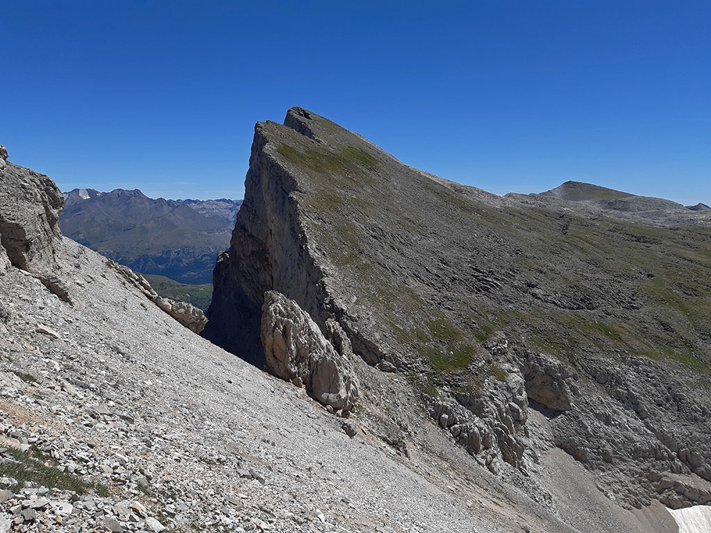
Tracks:
- In the background there is a peak with some very characteristic marble beds.
- The peak we are looking for is no tresmil.
- Reaching its summit is like travelling to the Caribbean.
Solution:
The Puerto Rico peak or point (2.753m)at the western end of the Sierra de Partacua. A little known area due to the remoteness of the place which concentrates a good number of lonely peaks. The photo is taken from the ascent to Peña Retona and if you haven't been there yet, here you have this one. route for masochists from Acumuer.
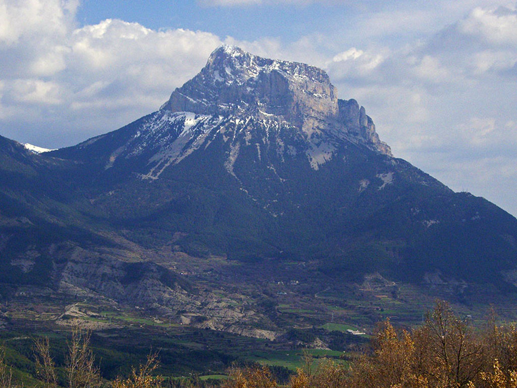
We are looking for this place #4
The statue of a cyclist. Although it could be in many places, there is surely one that we have all thought of first. Do you know the statue? Do you know who it is?
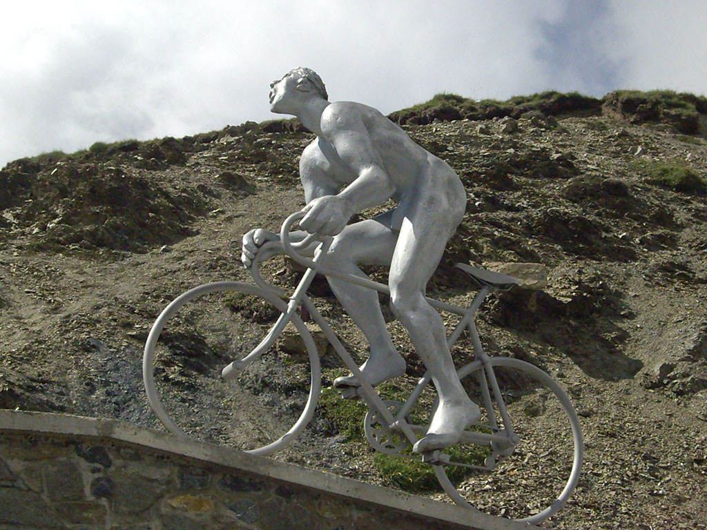
Tracks:
- He is in a mythical place of the Tour de France, but not always. He prefers to spend winters in the valley.
Solution:
The statue we were looking for can be found in the Tourmalet pass (2115m). This 3-metre high, 350 kg sculpture, known as the Octave the GéantIt was built in memory of Octave Lapize, the first cyclist to climb the Tourmalet during a stage of the Tour de France in 1910, in a stage lasting 326 km and 14 hours. As a curiosity, to protect it from the cold between October and June, it is lowered to Gerde, at the Laurent Fignon centre.
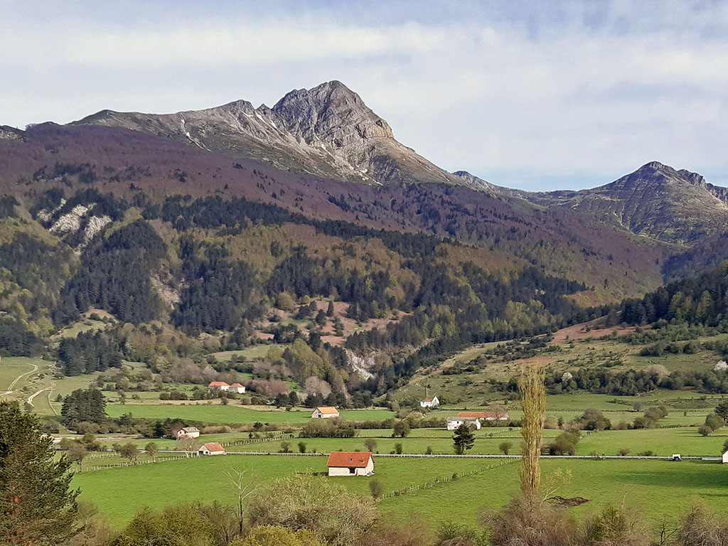
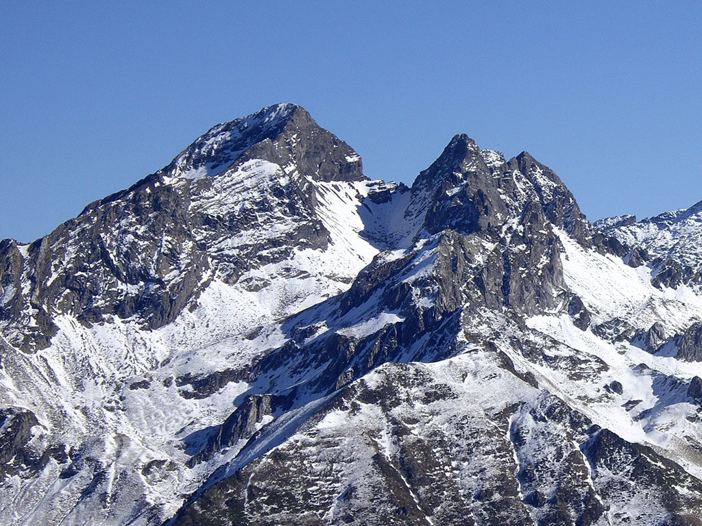
We are looking for this place #5
What a majestic mountain! Its silhouette is unmistakable and, although it is not the highest peak in the region, it is the most emblematic and desired mountain in the whole area.
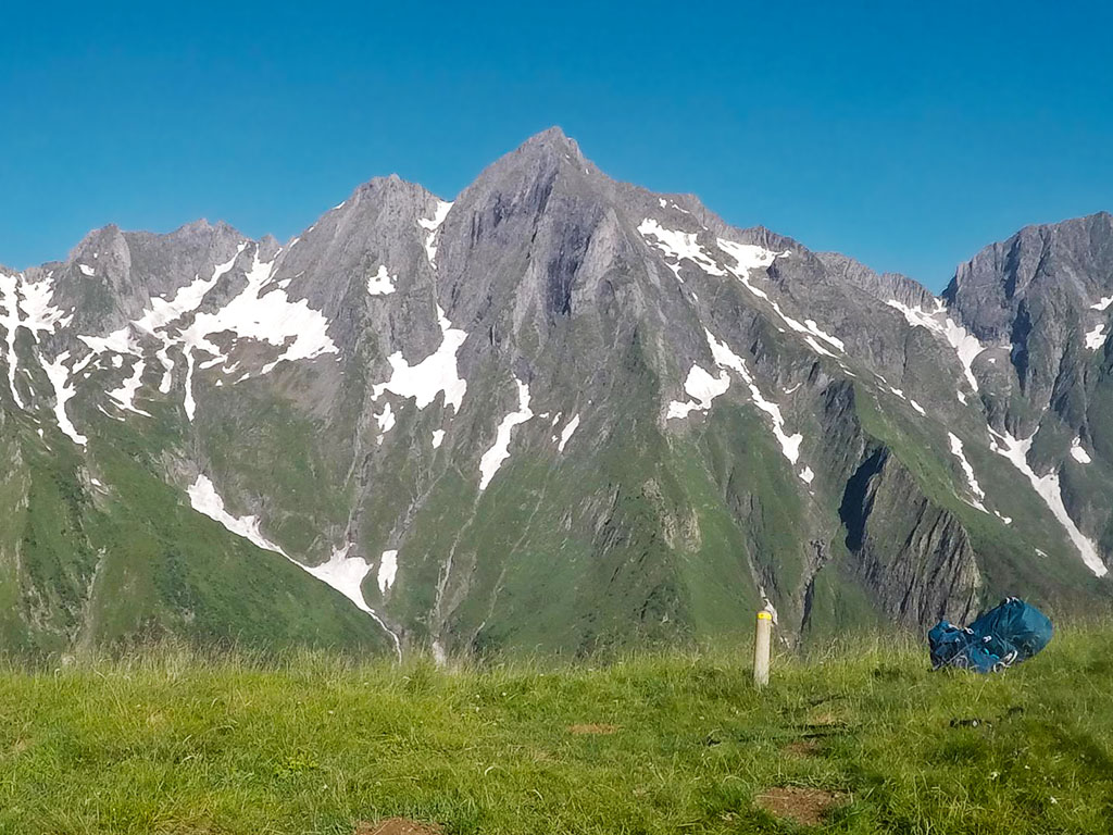
Tracks:
- It lies to the north of the axial axis of the Pyrenees mountain range, slightly separated from a long range of mountains that act as a natural border.
- Although it does not reach 3000 metres, it is by right one of the great Pyrenean peaks.
- The photo is taken from a small variant of the GR10on its way through the Ariège.
Solution:
This unmistakable mountain is... the Mont Valier ("Le Seigneur de l'Ariege). According to legend, its name comes from the bishop Saint Valerius, the first person to reach its summit in the 5th century. The most frequented routes run from the Perosa bridge in the south and from the Estagnous hut in the north, in the middle of the route. Pass'Aran. The photo is taken from the Pic de Lacrabere, during a very long stage of the GR10 between Rouze and Esbintz.
We are looking for this place #6
Routes to mountain lakes are very rewarding, like the one that leads to this lake in the Benasque valley. Do you know which one it is?
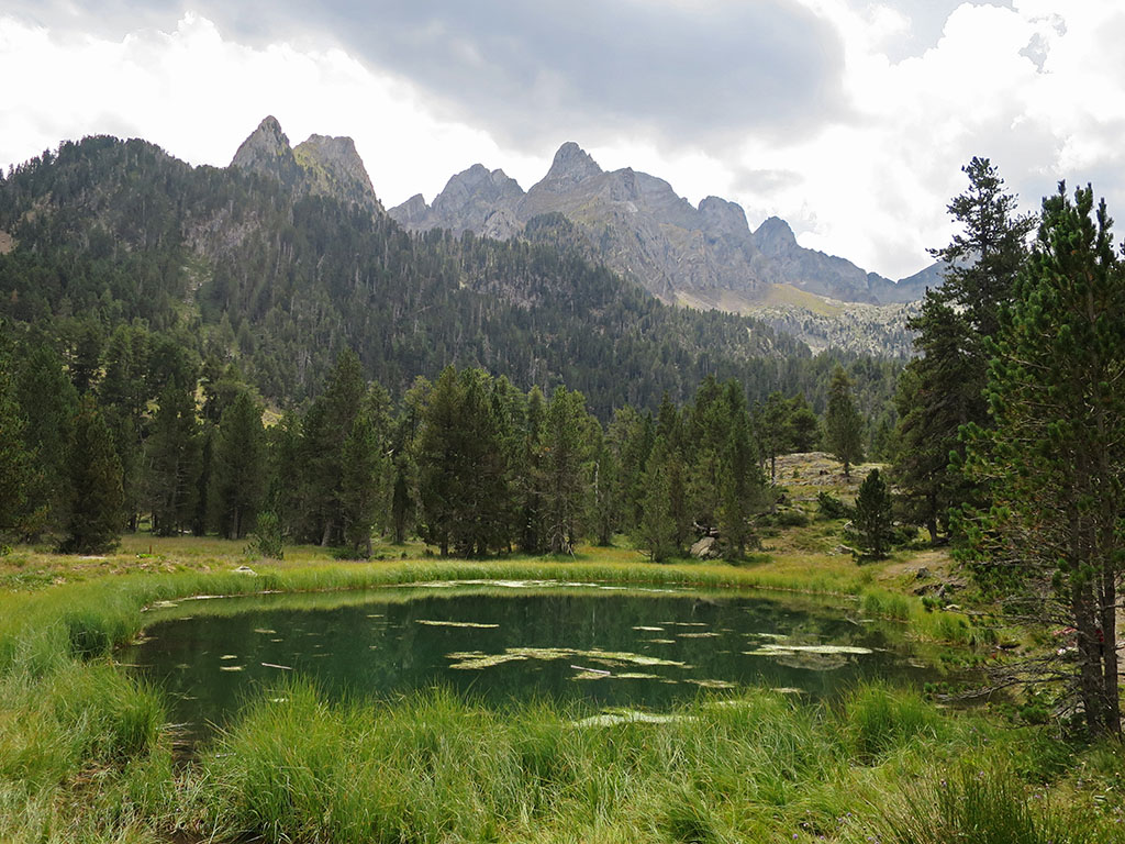
Tracks:
- The lake is located in the Benasque valley.
- The excursion to this lake is one of the most popular in the area and although it is not difficult, you have to walk a long way and climb quite a steep slope.
Solution:
The photograph corresponds to the ibonet de BatisiellesThe ibonet de Batisielles, in the Estós valley, one of the most important tributaries of the Benasque valley, is an idyllic place to relax and spend time contemplating the scenery. The ibonet de Batisielles is an idyllic place where you can relax and let the time pass contemplating the landscape. If you haven't been there yet, here you have this one route from the Estós valley car park.
We are looking for this place #7
This is one of the classic peaks of the Western Pyrenees and, although it is not the highest in the area, its pyramidal silhouette, easily distinguishable from any nearby mountain, makes it the focus of any mountaineer who frequents this part of the Pyrenees.

Tracks:
- Although the most common way to reach the summit is from the western slope, it can also be climbed from the eastern side, from where the photograph is taken.
- The excursion to the lake of the same name is one of the most popular in the area.
Solution:
The peak sought is the... Acherito or Mallo de Acherito (2.374m). The most common way to reach the summit is from Linza, from where we recommend this one. circular route.
We are looking for this place #8
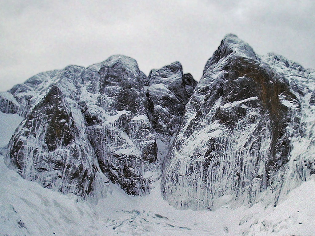
The limestone mountain areas are the ideal setting for speleology and in some places, such as this one, for the exploration of large cavities. However, if this cave is famous for anything, it is not for its depth or its development. Do you recognise it?
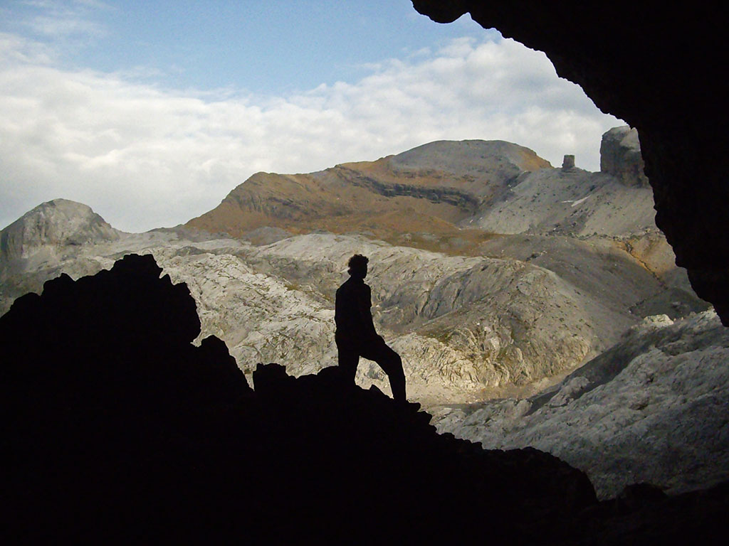
Tracks:
- The massif in which we find ourselves, perhaps the best known and most visited on both sides of the Pyrenees, is a favourable place for the formation of large caves. In fact, some have been discovered very close by that are more than 1,000 metres deep.
- This cave, discovered in 1926, is not particularly large, but it is well known for the unique icy beauty of its interior.
Solution:
This is the Casteret Ice Grottodiscovered" in 1926 by Norbert Casteret. Although it had already been known by some shepherds under the name of Black wig. The cave is located very close to the Rolando Gap, in the Ordesa y Monte Perdido National Park, and is considered to be the highest ice cave in the world (2,765m). Do you want to know more?
We are looking for this place #9
Throughout the Pyrenees we can find a good number of passages equipped with pegs, ropes or staples that, with a certain degree of safety, allow us to cut or save a good amount of height difference in our excursions. Do you know which place is this one in the photograph?
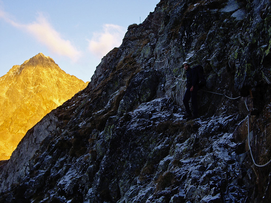
Tracks:
- We are on the French side.
- This pass avoids having to descend almost 200 metres to reach one of the oldest (1920) and most "traditional" shelters in the Pyrenees.
- The peak that appears in the background is one of the great giants of the area and, by a very small margin, falls short of being a 3,000m.
Solution:
Many mountain lovers have heard of the Soaso peaks or the Cotatuero peaks. Less well known, however, are other passages such as this one, the Orteig Pass. A traverse equipped with ropes that crosses the north face of the peak of Lac d'Arrious, connecting the col d'Arrius with the refuge of Arremoulit, and which allows us to avoid a descent of 200m to almost the Lac d'Artouste.
We are looking for this place #10
This week we have made it easy for you. There are few mountains that rise so strongly above the horizon and dominate the landscape as this one does.

Tracks:
- From the top of this lookout point in the western Pyrenees, you can see the Cantabrian Sea on clear days.
- A geodesic vertex on the summit confirms that this is a "dosmil".
Solution:
It could be none other than the Orialso Orhi, Orhy, etc. The Ori (2,018m) is the westernmost 2,000m in the Pyrenees and the first great mountain coming from the Cantabrian Sea. A colossus that rises above the Irati Forest and dominates the Larrau pass, from where the most popular route climbs.
We are looking for this place #11
This is a unique area in the Pyrenees, of incomparable beauty. Water is the main feature of the scenery, with hundreds of ponds that sweeten the landscape, where granite ridges stand out, such as the one we are looking for (on the right).
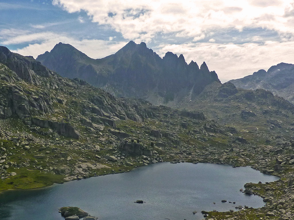
Tracks:
- The 5-pitch traverse (AD+) is one of the great climbing classics of this massif.
- The first ascent of the first two spires was in 1919, while the upper spires had to wait until 1926, a few days before the first crossing of its 5 towers was achieved.
Solution:
The Agulles de Travessanyin the heart of the P.N of Aigüestortes i Estany de Sant Maurici, it is a well-known place for its proximity to the Ventosa i Calvell refuge and for the numerous routes that pass by them, such as the Carros de Foc or the GR11.
In 1919, W. Illges achieved the first ascent of the first two peaks and later, on 11 July 1926, A. Oliveras, I. Folch and I. Bultó managed to climb the upper peaks. The first traverse was made a few days later, on 1 August 1926, by Abadie, Arlaud, Bridenner, Marceillac, Maigné and Mothe.
We are looking for this place #12
Perhaps the last few metres before reaching the summit are the moment of greatest happiness, even more so than reaching the summit itself. First one step, then another, slowly, take a breath and take a look at the landscape. Savour this unique moment and find a space in your mind for the memory.

Tracks:
- It is the culminating point of one of the 11 large areas in which the 217 Pyrenean three-thousanders are concentrated.
- This area is one of the areas with the highest concentration of three-thousanders. Practically one fifth of the total is found here.
- Although the origin of its name is unknown, one of the most probable explanations refers to its "stony seas". This is probably why Schrader, in 1874, claimed that this mountain could be demolished by 100 men in a month.
Solution:
The Red-legged retrieverwhose name is not entirely clear, could be due to the presence of snow partridges or to its "rocky seas". The first ascent may have been made by Parrot in 1817 or by Lézat and his guide Jean Marie Redonnet ("Michot") in 1850.
The Perdiguero (3,222m) is the highest point of the Clarabide-Posets area which, according to the official list, recognised by the UIAA, and included in the book "Pirineos Guía de los 3.000" by Luis Alejos, concentrates a total of 42 3,000m peaks.
We are looking for this place #13
Well, what we are looking for this time is not a place, but this plant which flowers in spring and which, in some beech forests, can be found populating the undergrowth.
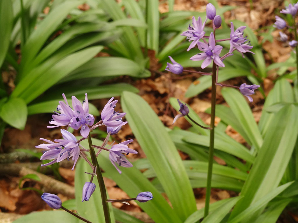
Tracks:
- This species of Hyacinth, endemic to Europe, can be found in central and southern France and northern Spain. It is mainly found in the Cantabrian-Pyrenean axis and some areas of the western Iberian system.
- Its preferred habitat is the shade of a beech forest, in deep, fertile soil.
- In temperate areas of the Cantabrian coast it flowers in March, however, at higher altitudes, around 1800m, its flowering can be delayed until June, before the beech trees put out their leaves and the hyacinths are shaded by them.
Solution:
I am sure that on more than one occasion you have come across a Scilla lilio-hyacinthus, commonly known as the Starry hyacinth, Hill o Scylla of the Pyrenees. Also Berín or Escayera in Asturias, or Joliu or Escila in Catalonia.
We are looking for this place #14
The snow has begun to retreat and, in a few days, the place we are looking for will look very much like the one in the photograph, with only a few snowdrifts, faithful witnesses of winter. The refuge you can see will also come out of its winter lethargy and, as always, since 1899, it will once again be ready to welcome the mountaineers who come up here.
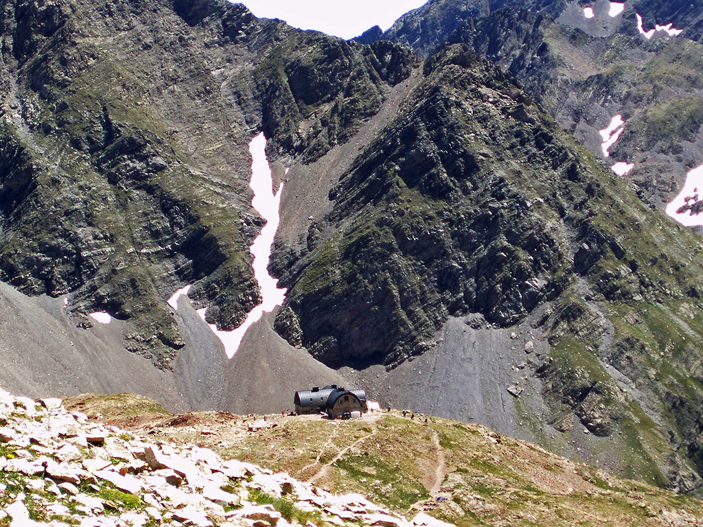
Tracks:
- The refuge we are looking for is an obligatory stopping point in the GR10 and the High Pyrenean Routeand the perfect base camp for climbing the great colossus of this area, one of the most emblematic mountains in the Pyrenees.
- This is one of the oldest shelters in the Pyrenees (1899), but its construction did not initially have the permission of Henry Russel, the owner of the mountain. Russel himself, when a few years earlier he built the Tucarroya refuge together with the CAF, stated that: "There is nothing uglier, more frightening, more repulsive than a house in the midst of the eternal and sublime chaos of the mountains".
Solution:
The Baysellance refuge is the highest sheltered refuge in the Pyrenees and one of the oldest (1899). Enlarged in 1933 and renovated in 2003, it has preserved the peculiar architecture of its time, with a vaulted structure and copper roof.
We are looking for this place #15
We are in one of the most famous spots in the Catalan Pyrenees, which attracts thousands of people every year: tourists, mountaineers, canyoners and devotees. Have you guessed it yet?
Tracks:
- The descent of this canyon is one of the most complete and enjoyable in Catalonia, although it is also technical and dangerous.
- The GR11 runs through this ravine which, in its upper part, gives access to one of the most visited valleys in the Catalan Pyrenees.
- If walking is not your thing, another option is to take the cog railway.
Solution:
With the clues we have given you, it could not be any other place than the Gorgues de Nuria. One way to get to know them is to go on foot, following the GR11 from Queralbs. Another more comfortable option is to take the rack railway. The third, only for experienced canyoners, is to descend the canyon.
The bridge you can see in the photo is very well known among the latter, the well-known Salt del Sastre, a 12-14 metre jump only suitable for people whose legs do not tremble.
We are looking for this place #16
This week we crossed to the northern slopes of the Pyrenees to cross this impressive wooden and steel cable footbridge, suspended 150m above the ravine.
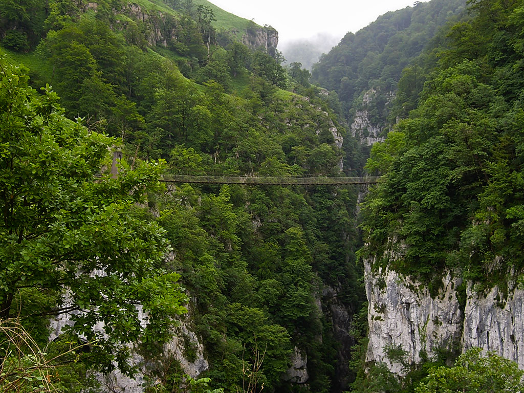
Tracks:
- The constant humidity caused by its northern orientation and its proximity to the Cantabrian Sea give this ravine a mysterious, jungle-like appearance.
- The undoubted beauty of this place has not gone unnoticed, and the one-and-a-half hour walk (there and back) has become a tourist attraction and one of the most popular excursions in the area.
- The starting point for this excursion is the obligatory point of passage in the GR10.
Solution:
This is the Holtzarte footbridgeIt is located on the Olhaldubi ravine, at the confluence with the Holtzarte gorge. It is located in Zuberoa, one of the 3 historical provinces of the northern Basque Country (Iparralde), in the French department of the Atlantic Pyrenees. A small paradise of steep mountains and lush vegetation where, in addition to enjoying this canyon, we can visit two others of equal beauty, Kakueta and Ehujarre. A place not to be missed go and visit.
We are looking for this place #17
A ridge of sharp needles and a deep gorge. At first sight it doesn't look like a very important place, but every year thousands of people pass through here.

Tracks:
- The massif in which we find ourselves needs no introduction.
- Wherever we go, ice axes and crampons are an indispensable part of our equipment. Even more so in the summer, when the snow disappears and only ice remains.
Solution:
This is the Portillón Superior/upper Maladeta pass. Although this is the normal route by which every year thousands of people climb the roof of the Pyrenees, the Aneto, this was not the route of the first ascent (via the Coronas valley).
The first ascent of the upper Portillon took place only 4 days later. Apparently, Tchihatcheff sensed from the summit that the shortest way down to La Renclusa was via the glacier on the north face. Not satisfied with the refusal of his companions to descend this side, he returned to the summit by this original route in the company of Laurent.
We are looking for this place #18
There are places that one never tires of returning to, however, this time it will not be to go into the canyon, but to admire it from above.
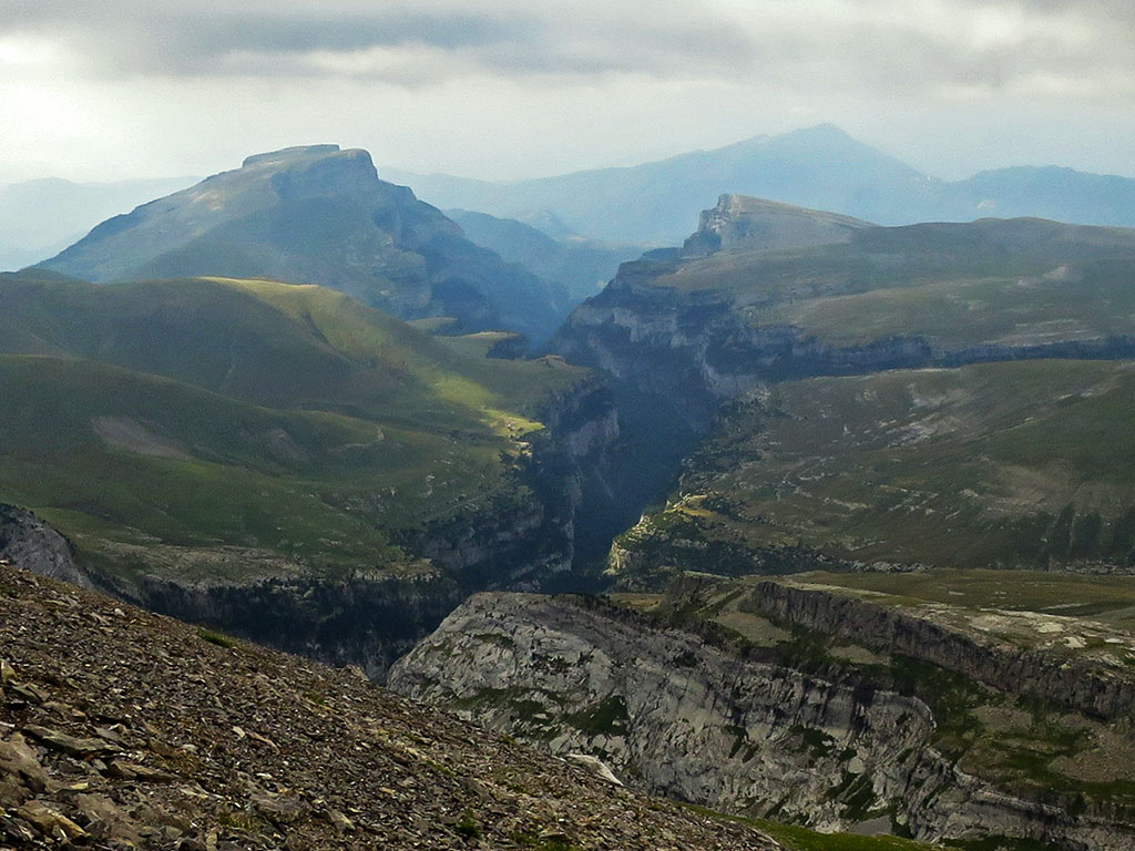
Tracks:
- This is one of the largest and most renowned canyons in the Aragonese Pyrenees.
- The head of the ravine is a perfect example of a glacial trough, but the part we can see is the result of water erosion on the limestone rock.
- This unique place has been part of the National Park since 1982.
Solution:
The Añisclo Canyonin the Ordesa y Monte Perdido National Park. From the vicinity of the San Urbez bridge there are several hiking routes that allow you to get to know it from the inside or to access places from which you can contemplate it. In this case, the photograph is taken from above, at the beginning of the Faja de las Olas, along which the variant GR11.9 of the Senda Pirenaica.
We are looking for this place #19
We are looking for this great peak, stark, slender, one of the must-sees on the curriculum of any self-respecting Pyrenees climber.
Tracks:
- For some, this is the first great mountain in the Pyrenees coming from the Bay of Biscay.
- This mountain, the highest point in the area, dominates like no other the great karst plateau that stretches out at its feet.
Solution:
The peak Anie or Auñamendi is the highest mountain in the Larra massif and the first to surpass the 2,500m barrier from the Atlantic Ocean. It is a mountain of sublime lines, a perfect pyramid that dominates the great karst plateau of Larra as if it were a petrified glacier. A unmissable ascent.
We are looking for this place #20
Between the peaks of Nuria and the Mediterranean, the Pyrenees extend a series of mountains below 2,000 metres with increasingly friendly contours. Among these peaks, one of the most outstanding is the one in the background of the photograph, do you recognise it?
Tracks:
- On the descent from the pass of Lliens to Molló, in the middle of the Pyrenean PathIn the background, a mountain with an attractive silhouette stands out, what could it be?
- Although the Pyrenees no longer have the strength of other central regions such as Cerdanya or Ripollés, the Garrotxa, where our mountain is located, hides within it a rugged landscape of sharp peaks and deep ravines.
Solution:
The Comanegra (1.557m)in the Serra Llarga de Monars. As a curious fact, for conquerors of the useless, Comanegra is the southernmost point of mainland France and the highest and most northerly point of the Garrotxa region.
We are looking for this place #21
What a bucolic picture! We are going to the Western Pyrenees in search of this mountain, so representative and so often photographed in books, brochures and other publications.
Tracks:
- Its presence, at the entrance to the only valley of glacial origin in Navarre, welcomes us to this small corner of the Pyrenees.
- If you have been following Travesia Pirenaica's latest articles, you will have seen that we recently reached its summit.
Solution:
This time it was a trick, the solution is not Lakartxela but Keleta. It is precisely this position in the Belagua valley and the fact that it looks like an inaccessible mountain that often leads to Keleta being confused with the main peak, Lakartxela (1,982m), which is hidden behind it. One of the most beautiful and essential ascents in the Navarrese Pyrenees: Ascent to Lakartxela from Arrako, in the Belagua valley.
We are looking for this place #22
This is one of the great Pyrenean peaks. An emblematic mountain, the cradle of Catalan hiking.
Tracks:
- Although it is not clear where the Eastern Pyrenees begin and end, beyond Cerdanya there is no doubt, we are in the Eastern Pyrenees.
- Don't be fooled by the worn and gentle shape of its summit. The acronym of its name, "bad mountain", is due to the harsh climate and the strong winds that blow through the area. The dreaded Torb.
- You won't find a higher peak from here to the Mediterranean.
Solution:
This is the Puigmal (2.910m)The second most prominent peak in the Pyrenees, only behind Aneto. The most popular climb is the one that starts from the Sanctuary of Nuria. From here, those insatiable for summits can complete the entire route of the 19 peaks above 2,700m that make up the Olla de Nuria. A great classic of mountaineering and trail running.
We are looking for this place #23
Surely you have visited the place on some occasion. A medieval bridge like this one can only mean that we are in front of a historical crossing point, used by pilgrims, smugglers or shepherds since time immemorial.
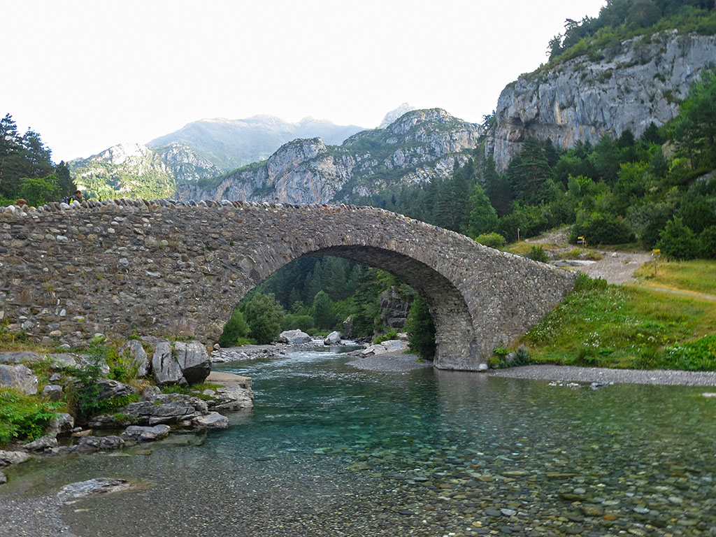
Tracks:
- We are in the heart of the Central Pyrenees. Starting point of some of the most famous three-thousanders of the mountain range and "obligatory" stop on routes such as the GR11 or the High Route of the Lost.
- Next to the bridge is the refuge of the same name, where the old pilgrims' hospital and the ruins of a Romanesque hermitage used to stand.
Solution:
This one is easy, the medieval bridge of San Nicolas de Bujaruelo (13TH CENTURY). Next to the bridge is the refuge of Bujaruelo, a former pilgrims' hospital (12th century) built by the monks of the Order of the Knights Hospitaller of St. John of Jerusalem, and the ruins of the Romanesque chapel of San Nicolás.
The area around Bujaruelo was a strategic place of communication between both sides of the Pyrenees. It was a crossing point for livestock to France, regulated by international treaty since 1390, a crossing point on the pilgrimage routes to Santiago de Compostela, and a defensive bastion in the mid-20th century in the face of the fear of a possible invasion from Europe.
Today, the site is frequented by tourists and mountaineers, among others, who climb from here up to the Taillon, VignemaleOtal, Tendeñera or the Rolando Gapand by travellers making the GR11 or the High Route of the Lost.
We are looking for this place #24
We return once again to the heights, to one of the most emblematic and highest peaks in the Pyrenees. From its summit, the views to the south show these two lakes as two blue eyes. Have you guessed it yet?
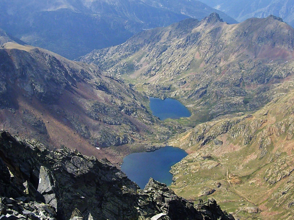
Tracks:
- Although Henry Russel may not have been the first to climb to its summit, he left us the first text about his ascent in 1864.
- Curiously, the neighbouring mountain, 65 metres lower and only 30 minutes away, was climbed much earlier, in 1807. Its position in front of the Ariège must have been decisive, and it was therefore considered to be the highest in the massif.
- At its summit you will find a large cross and a multitude of symbols.
Solution:
The photograph is taken from the top of the Pica d'Estats (3.143m)the Catalan roof. Already in the description we gave you the first clue by referring to the two blue lakes (Estats and Sotllo) as two eyes. This is how Russel referred to them from the summit "What radiance they showed in July 1864! They shone like two eighteen-year-old blue eyes. But today, solid and gloomy, they chilled the soul.
We are looking for this place #25
Its unmistakable silhouette, an icon, welcomes us to the valley.
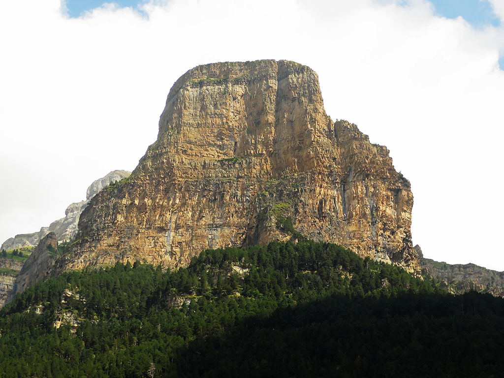
Tracks:
- A magnet for climbers of several generations, it was the first of the great walls of this climbing temple to attract the gaze of the pioneers.
- Its position overlooking the valley and the orange colour of its walls at sunset are a symbol of the National Park, the second oldest in Spain.
Solution:
You recognised it, didn't you, it's the Tozal del Mallo o "Altarpieceas this prodigious wall was known in the old days, which welcomes us to the Ordesa valley.
The first route to directly climb the walls of the south wall was signed by Ravier (N.Biotti, C.Dufourmantelle, C.Jacoux, M.Khan and J.Ravier), in April 1957, a few weeks ahead of the Aragonese team of Bescós, Montaner and Rabadá. However, as a curious fact, a certain Gavín, a smuggler by profession, had already climbed these walls in his imagination in 1944. He would draw a sketch of that "opening" which would later be included in the legendary Ollivier guide.
We are looking for this place #26
There are probably very few places in the Pyrenees that can compare with this place, a paradise for winter climbing and an ideal place for mountain biking or family outings during the summer.
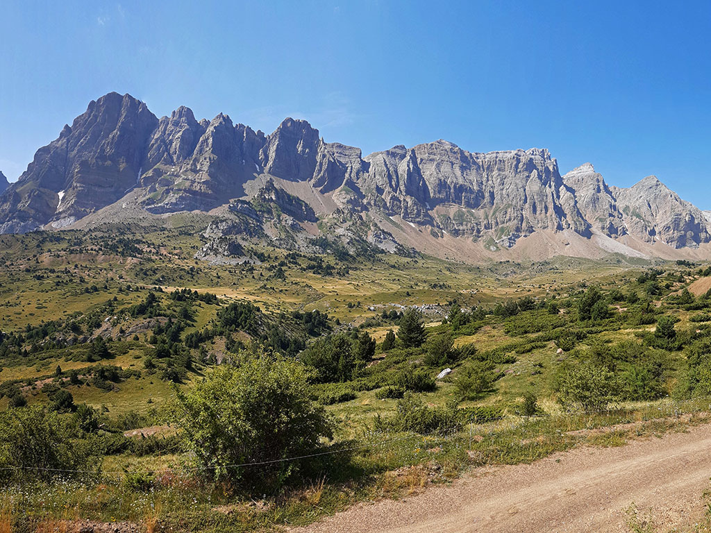
Tracks:
- From left to right we can see almost the entire mountain range. One of the most outstanding inland mountain ranges in the Aragonese Pyrenees. A knife-edge of sharp limestone towers that plunge 600-700 metres into the peaceful valley.
- The photo is taken from the northern slope, from the track that follows a circular route that takes us to the walls of the sierra. This is a well-known route for bicycle lovers.
Solution:
This is the Sierra de la PartacuaIt is best known for being the site of Peña Telera, the highest peak on the left of the image. The Sierra de Partacua is one of the inland mountain ranges that extend to the south of the Axial Pyrenees. The magnificent crest formed by limestone gives it away. If you would like to visit its summits, we recently made this route to Peña Telera which runs along several of the eastern peaks of the sierra, and this other one at Peña Retona from Acumuer, in the westernmost area.
We are looking for this place #27
The place we are looking for this week needs no clues or introductions, we are in one of the most famous, photographed and visited places in the Pyrenees.
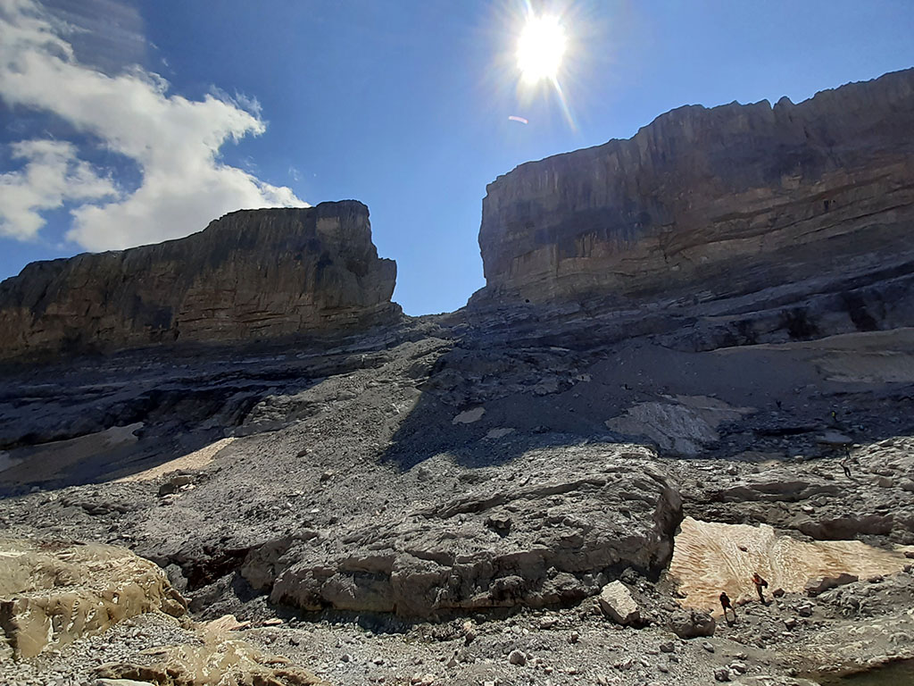
Tracks:
- Although the gap is at an altitude of 2,800 metres, the hike up to it is very easy and consequently very busy in the summer months. No doubt the road on the French side, which leaves us at an altitude of 2,200 metres, is largely to blame.
- The fascinating and mysterious nature of this enormous gorge has given rise to one of the best-known legends of the Pyrenees, from which this place gets its name.
Solution:
The Rolando Gap is located on the border between Spain and France, in the western part of the mountain range Pyrenees-Monte Perdido. The gap, very accessible thanks to the road that goes up to the col des Tentes, is already a very popular place as it is located between the Pyrenees National Park (French) and the Ordesa and Monte Perdido National Park, and is a "must" to reach the Taillon (Punda Negra) from the French side. One of the most accessible three-thousanders.
Back to the Roland Gap. Its name comes from a famous legend that we already told you about some time ago: the legend of the Rolando Gap.
We are looking for this place #28
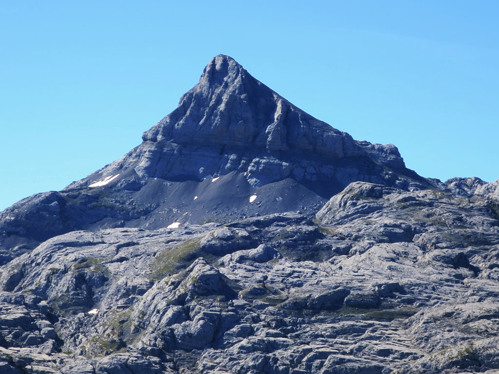
Today we move to the western end of the Pyrenees, to the summit of this unique mountain crowned by three peaks of similar altitude.
Tracks:
- Its summit is a magnificent viewpoint over the Basque coast.
- The rocks that form these mountains are particularly ancient, more than 250 million years old, and of a totally different origin from the rest of the nearby mountains.
- The Gipuzkoa side has been a natural park since 1995.
Solution:
It is about Aiako Harria (Crags of Aya)one of the first mountains in the Pyrenees coming from the Cantabrian Sea. The photograph is taken from Erroilbide (832m) towards Irumugarrieta (806m) and Txurrumurru (821m). In the background is the Cantabrian Sea, just 8kms away.
The spur on the left is the Muganix. This is where the Erlaitz I route ascends, a beautiful climbing route on a rock that emerged from the bottom of the sea 280 million years ago, which we shared with you some time ago: West spur of Muganix (80m, 4b) and Irumugarrieta-Txurrumurru-Erroilbide crest.
We are looking for this place #29
This week we come down from the peaks to discover this small corner of the Eastern Pyrenees, very close to the Mediterranean Sea.
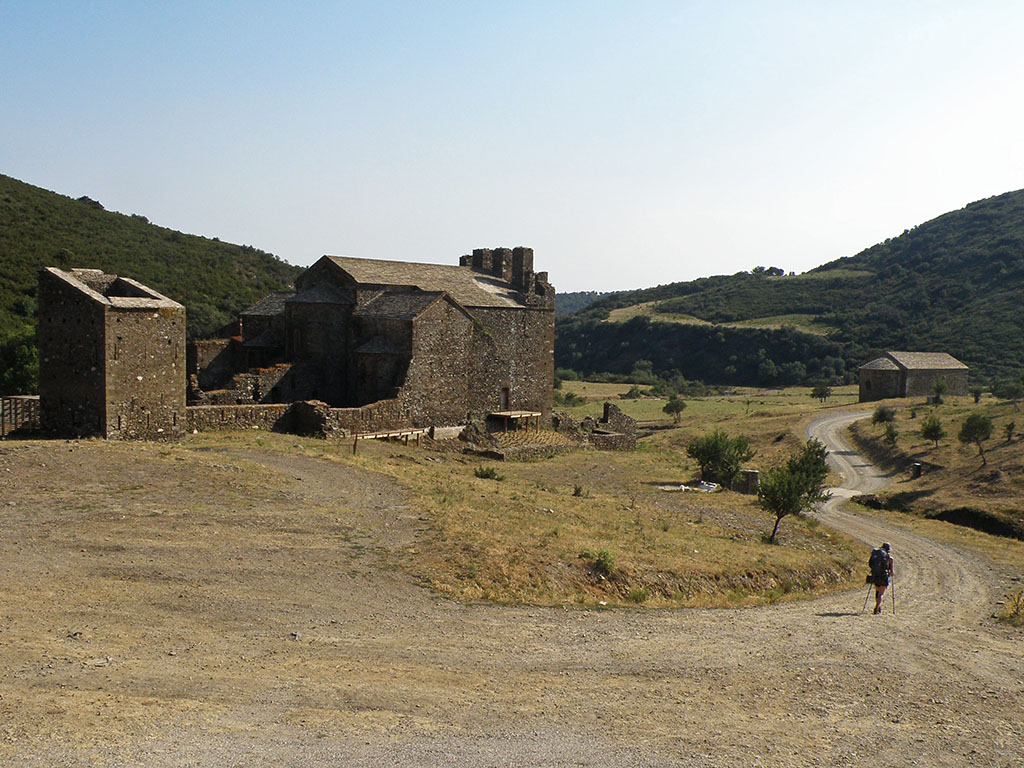
Tracks:
- We are in Alt Empordà, an area of great natural and scenic interest that also has numerous megalithic monuments and human remains, or as in this case, a monastery.
- The area we are in is a Natural Site of National Interest and a Partial Nature Reserve for the protection of the Mediterranean turtle.
- The GR11 passes through this place.
Solution:
The Benedictine monastery of Sant Quirze de Colera. I'm sure that all of you who have ever done the GR11 you have recognised the place. We visited it some time ago when we were walking the Senda Pirenaica, on the stage 44 of the guide available online.
The monastery is currently undergoing restoration. Its origins are somewhat unclear. Although the monastery was consecrated in 935, there are not very reliable documents that speak of the monastery in the 9th century, as well as some tombs found from the 8th century.
We are looking for this place #30
We continue our journey through the Catalan Pyrenees. In the middle of the descent towards this great valley, do you recognise it?

Tracks:
- The sheer size of this valley and its east-west orientation make it an exceptional case in the Pyrenees.
- In 1659, as a result of the Treaty of the Pyrenees between the kingdoms of Spain and France, this region was divided into two territories.
- The photograph was taken in the middle of the Senda Pirenaica.
Solution:
Clearly, we are in the Cerdanya (Catalan) or Sardinia (Spanish). From a geological point of view, this is a completely unique valley. Its East-West orientation, somewhat deviated, contrasts with the predominant North-South or South-North orientation of the main Pyrenean valleys. The great width of this valley is also completely unusual, separating the Nuria mountains to the east from the rest of the Pyrenean chain. So much so that Puigmal (2,910m), to the east of Cerdanya, is the second most prominent peak in the Pyrenees after Aneto.
We are looking for this place #31
This week we are flying over the Aragonese Pyrenees to see this lake from a lesser known perspective.
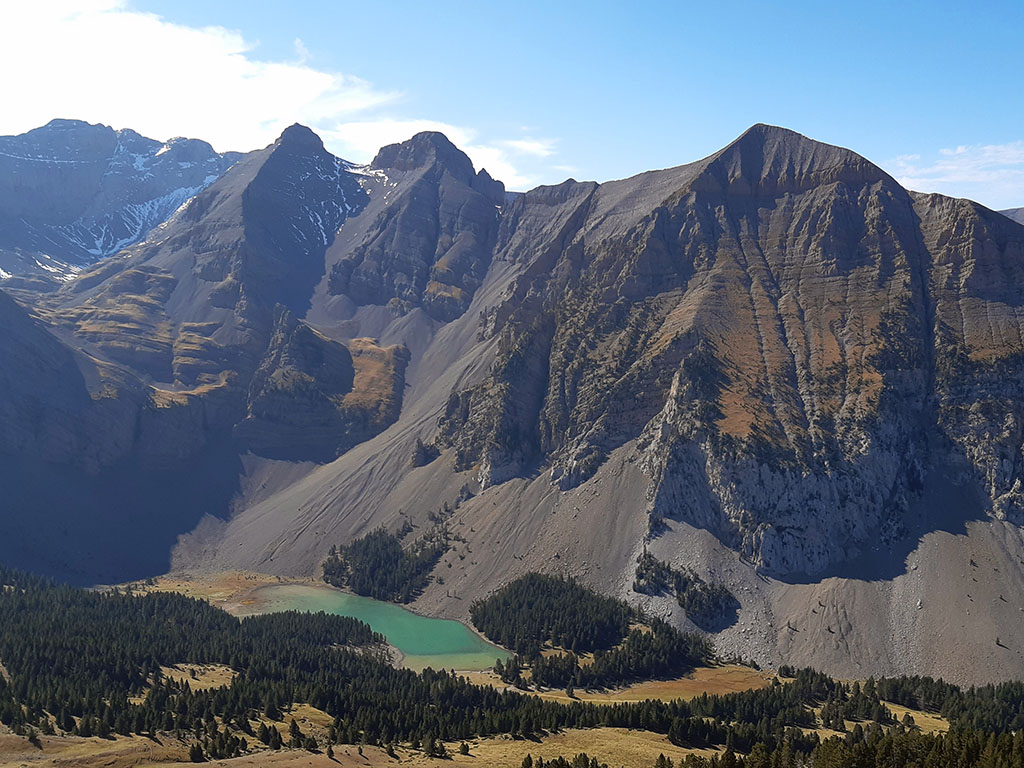
Tracks:
- The excursion to this lake is ideal for children thanks to a track that climbs up to 1900 metres, and which leaves us just 25 minutes from this place.
- The singular beauty of this massif, stark, devoid of vegetation, contrasts with the turquoise waters of the lake and the greenery of the pines and grass on its banks.
Solution:
The ibón de Plan o Basa de la Mora is one of those essential places to visit at least once in your life. It is a very popular place thanks to the track that goes up from Saravillo to the Lavasar refuge, just 25 minutes from the lake.
Although many of you probably already knew about this place, perhaps the photograph, taken on the descent of the Peña del Mediodia, may have misled you. A highly recommended excursion for those who still want something more during their visit to the Ibón de Plan: Peñas de las Diez, Once and Mediodía from the Lavasar hut.
We are looking for this place #32
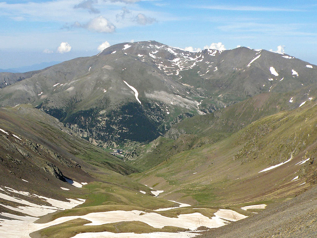
The glaciers of the Pyrenees, like the glaciers of the Alps and other parts of the world, are doomed to disappear. In the Pyrenees it is thought that they will have disappeared irretrievably by the middle of this century, but until then, do you know which glacier it is?
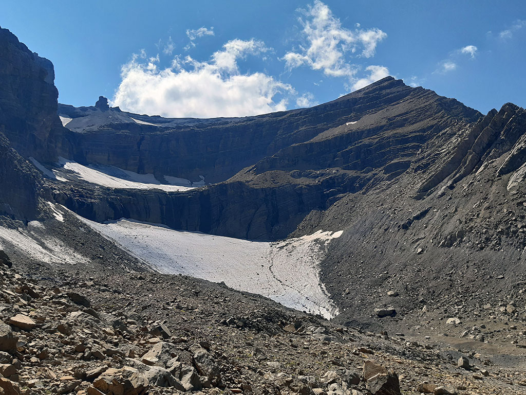
Tracks:
- Like most Pyrenean glaciers, it is located on the north face, on the French side in this case.
- The mountains in the background are a good clue, especially that distinctive crag on the left of the picture.
- The peak on the right is one of the easiest to climb in the Pyrenees.
Solution:
This is the Taillon glacierwith the Dedo (2,948m) and the Taillon (3,144m) in the background. If you remember, a few weeks ago we echoed a photo published on twitter by Météo PyrénéesThe present state of the glacier was compared with that of 1924.
According to the website Pyrenean glaciersAlthough it is a very small glacier (9 hectares in 2013), it is relatively well preserved due to its orientation and the large feeding basin. If you want to visit it, the photo is taken on the final ascent to the Roland Gap hut, during one of the excursions that we propose in the group. Ordesa-Monte Perdido-Gavarnie.
We are looking for this place #33
From time to time the mountains offer us geological caprices like this one, a true wonder of nature. A huge window in which it is irresistible not to stand in front of it and look through it.

Tracks:
- We are in Aragon, in one of the most important inland mountain ranges of the Pyrenees.
- The backlighting behind us does not allow us to distinguish the mountains in the background very well, but we are in front of the first Pyrenean three-thousanders.
- Please don't try but, perhaps many of you remember the incredible base jump of Álex Villar in 2012, crossing the arch at 230km/h in his wingsuit.
Solution:
The so-called Pyrenean interior mountain ranges, formed mainly by sandstones and limestone materials from the Mesozoic and Palaeocene, form a band of mountains to the south of the axial Pyrenees in which erosive phenomena have modelled some places as curious and marvellous as this one: the Piedrafita geotectonic arch, in the Tena Valley.
Its formation can be explained by the presence of a stratum more resistant to water erosion. The water must have worn away the sandstones of the upper levels, uncovering this more resistant band, while an ancient subterranean karst conduit continued to line this tunnel. A place you can't miss and that some time ago we visited in this tough excursion to: Peña Blanca Alta, Peña Parda and Peña Telera.
We are looking for this place #34
The place we are looking for this week, although we may not know its name, needs no clues.

Tracks:
- To visit this place you will have to travel to the Catalan Pyrenees, to one of its most famous valleys.
- As you will have noticed from the architectural style, this is a Romanesque church, Lombard Romanesque to be more precise.
- In the year 2000, UNESCO declared the Romanesque ensemble of this valley (8 churches and a hermitage, although there are more) a World Heritage Site.
Solution:
The church in the photograph is that of Sant Climet de Taüllone of the 9 buildings that make up the Romanesque ensemble of the Vall de Boí, declared a World Heritage Site in the year 2000.
Although we could spend some time talking about these marvellous constructions, we prefer to leave you with the words that Patrice de Bellefon dedicated to them in his mythical book: The Pyrenees. The 100 best ascents and excursions.
"How is it possible that with such crude materials and rudimentary tools a mountain people could build such sublime monuments? We, seasoned mountaineers, who are only impressed by a few terrible mountains, who have our own down clothes and sharp crampons, realise how alien we are, however, to the real world of the mountains. We regret not being humble descendants of those brilliant builders and we would like to have been born in Tahull, to be from this valley".
We are looking for this place #35
This week we travel to the Aragonese Pyrenees in search of this curious mountain with its stratified relief.
Tracks:
- We are in the Huesca Pyrenees, in the Western Valleys Natural Park.
- Although it is a beautiful mountain to climb, the nearby presence of the Bisaurin, the giant of the area, keeps it safe from crowds.
Solution:
The mountain in the background is the Agüerri (2.447m)The second highest peak after Bisaurín, on the left bank of the Aragón Subordán. The photograph corresponds to its north face, the most attractive, and was taken in winter from the summit of Secús. If you are up for it, in the following links you will find the descriptions of how to climb it Secús and the Agüerri from Gabardito.
We are looking for this place #36
This week we've made it easy for you again: who among you has never looked at this huge rock?
Tracks:
- We are in Aragon, in the Sobrarbe region.
- Its position set back from the Pyrenean axis, together with its abrupt relief, make this mountain visible from anywhere and turn it into a real beacon of the lowlands of this region.
- Precisely, all of the above makes this mountain one of the most prominent in the Pyrenees and the Iberian Peninsula.
Solution:
This is the Peña Montañesathe highest point of the Sierra de Ferrera. Peña Montañesa is a well-known mountain, which does not go unnoticed despite its modest altitude (2,294m) and which, just a few kilometres from the historic town of Aínsa, or every time we take the road towards Bielsa, Pineta or the Chistau valley, is sure to have caught our attention.
We are looking for this place #37
This week we propose you to find this inseparable pair of peaks. Two solitary mountains with elegant edges and sharp fangs.
Tracks:
- Many of you will probably be familiar with this picture as it is the legendary cover of Miguel Angulo's second book, Pirineos 1000 ascensiones.
- Precisely, the full title of this book is, "Pyrenees II - 1000 ascents. From Somport to Vignemale". With this we would already have them well located.
- The face of the mountain we are looking at in the photograph is the south face. To climb it, it would be better to cross to the other side and access it from the north side.
Solution:
The Lurien (2,826m) and the Pics d'Arrious or Pics d'Arrius (2.748m and 2.728m) are located on the French side, between the valleys of Ossau and Azun, next to the road that crosses the Portalet pass. The most common starting points for climbing them are the Lac de Fabrèges and the Lac d'Artouste. The photograph is taken from the Grande Raillère, from the neighbouring Midi d'Ossau.
We are looking for this place #38
With this winter weather, we couldn't resist sharing this photograph that will surely leave you frozen.
Tracks:
- We are on the French side of the Pyrenees, in front of one of the most important three-thousanders of the mountain range.
- The most famous snow and ice itineraries in the Pyrenees have been traced on this great wall.
Solution:
The photograph, taken from the Oulettes de Gaube hut, is of the north face of the Vignemale. The north face of the Vignemale has historically represented the greatest challenge for Pyrenees mountaineering. It is the most "alpine" wall in the Pyrenees, 800 metres of verticality under the Pique Longue, glaciers and a vertiginous chimney that divides the wall in two, the Couloir de Gaube, the most famous and prestigious winter climb in the Pyrenees.
We are looking for this place #39
This week we invite you to look for this impressive canyon, does it ring a bell?

Tracks:
- We are in the Navarrese pre-Pyrenees, overlooking this magnificent viewpoint.
- Although perhaps not the best known, this is the largest gorge in the community.
Solution:
This is the Foz de Arbaiun. Almost 6 kilometres long and more than 300 metres deep, the Arbaiun gorge, crossed by the river Salazar, is a Nature Reserve and SPA. The largest colony of griffon vultures in Navarre is conserved here, with 199 pairs according to data from 2018.
This is the most typical view from the viewpoint of the Iso pass. If you feel like walking a little, from Peña Cornota or along the Canaleta route, you will find two different perspectives.
We are looking for this place #40
What is it about waterfalls that attracts us with such fascination? Is it pure beauty, is it the roar of the water as it rushes down, is it the coolness they give off in summer, or is it, as in this photograph, the struggle not to end up frozen.
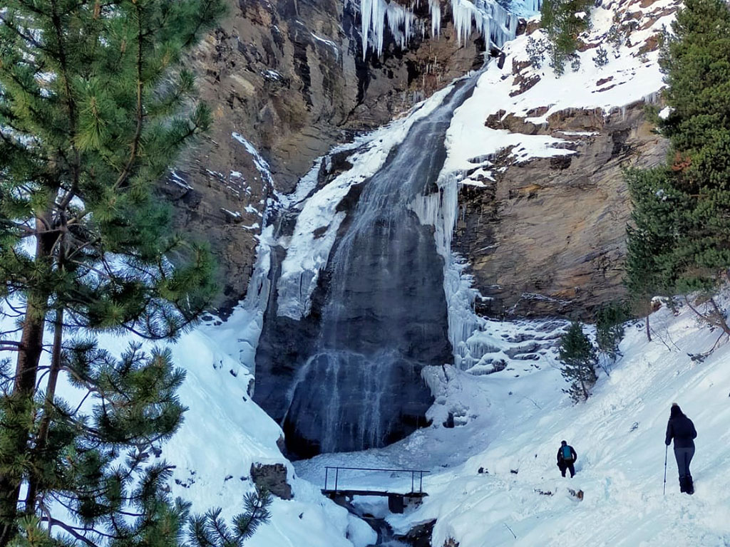
Tracks:
- The excursion to this waterfall is one of the easiest and most pleasant routes in this valley, which has the highest concentration of three-thousanders in the whole of the Pyrenees.
- A visit to this waterfall is usually accompanied by a visit to two other nearby waterfalls.
- The starting point of the route to this waterfall sounds like a ski resort.
Solution:
The Ardonés waterfall o Bom waterfall is located near the village of Cerler. If you want to visit this waterfall together with the other two that usually accompany the route, there are two options, the first is circular and starts from the village of Cerler itself (7kms; +/- 250m), the second route is shorter (4kms; +/-120m) and starts from kilometre 9.5 of the road that goes up to the ski resort of Cerler.