The best treks and climbs in Africa
Pyrenees and mountains 📩
Here 🔥Trekking is not usually one of the main reasons to travel to the African continent and as a tourist destination, it seems inevitable not to end up thinking about safaris, deserts and pyramids. However, the reality is that in a continent so vast and so unknown to most people, there are countless routes for mountain lovers. A whole world of wilderness to discover. These are some of the the best treks and climbs in Africa.

Ascent of Toubkal (4.167m) "
Type of route: ascent. It is generally a round trip, although there are other options. Duration: 2-3 days. Best time: can be done all year round, although it is advisable to avoid the sweltering summer heat and the cold, short days and heavy snow in winter.
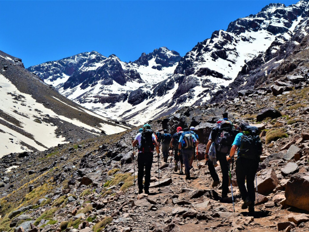
JBbel Toubkal
Jbel Toubkal (4,167m) in Morocco is the highest mountain in the Atlas Mountains and in the whole of North Africa. The Toubkal massif is home to the majority of the four Atlas mountains, 11 out of 14. The other three are in the M'Goun massif. Although the climb to the Toubkal is usually a round trip, the massif has many possibilities for trekking and climbing some of these four-thousanders. A great mountain range just a stone's throw from home, where you can discover some of the best treks and climbs in Africa.
Ascent of Toubkal
The most common starting point is Imlil on the northern slopes, just an hour and a half's drive from Marrakech, which has an international airport.
The climb usually takes 2 days. The first day you climb from Imlil (1.740m) at Toubkal refuge (3,207m) In about 4 or 5 hours and with all security, you will be offered a mule to carry your backpacks. Depending on the time of year, if it is spring, you will find snow before the refuge. If this is the case, you will need to use ice axes and crampons from the refuge onwards. The ascent and descent from the refuge to the peak can take about 7 hours, to which we will have to add another 3 or 4 hours to Imlil if we do not want to spend another night up there.
Simien Mountains. Trekking and ascent to Ras Dashen (4.553m).
Type of route: trekking-ascension. Duration: 7 days including an acclimatisation day. Best time: October to May, during the dry season.
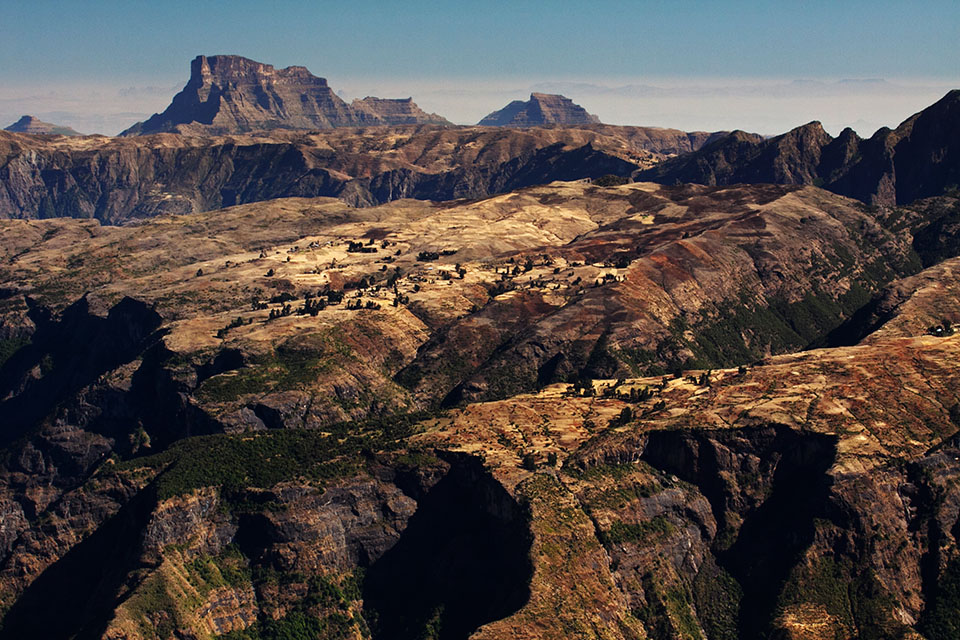
Simien Mountains:
The Simien MountainsThe Amhara Mountains, in northern Ethiopia's Amhara region, form one of Africa's major mountain massifs, the fourth highest in altitude. It has been declared a UNESCO World Heritage Site.
The relief of these mountains is very rugged, with deep gorges for which it is nicknamed the Grand Canyon of Africa and steep mountains that exceed 4,000 metres in altitude. The vegetation is surprisingly lush, with several endangered species surviving, including the Walie Goat, the Ethiopian Wolf and the Gelada, a type of baboon that is easy to spot. In addition, throughout the mountains there are numerous inhabited places. Lost villages where time has not passed.
The Ras Dejen or Ras Dashen (4,553m) is the highest elevation in Ethiopia and the 10th highest mountain in Africa (the other 9 peaks are concentrated in Kilimanjaro, Kenya and Rwenzori).
Trekking in the Simien Mountains and ascent of Ras Dejen / Ras Dashen:
The trek takes place all the time at high altitude, almost always above 3,000 metres, so it is advisable to take it easy and dedicate a day to acclimatise properly.
- Day 1: Buyit Pas - Sankaber Camp.
- Day 2: Sankaber Camp - Geech Camp.
- Day 3 (acclimatisation): Immetgogo (3,926m), Saha (3,785m) and Kedadit (3,760m).
- Day 4: Geech Camp - Chenek Camp.
- Day 5: Chenek Camp - Ambiko.
- Day 6: Ambiko - Ras Dashen (4,553m) - Ambiko.
- Day 7: Ambiko - Chiroleba.
The Danakil Depression.
Type of route: It is not really a trek in this area, but rather a visit to various places of interest that can be reached by off-road vehicle. Duration: it usually takes about 3 days to visit the area. Best time: winter. Mid-November to mid-March.
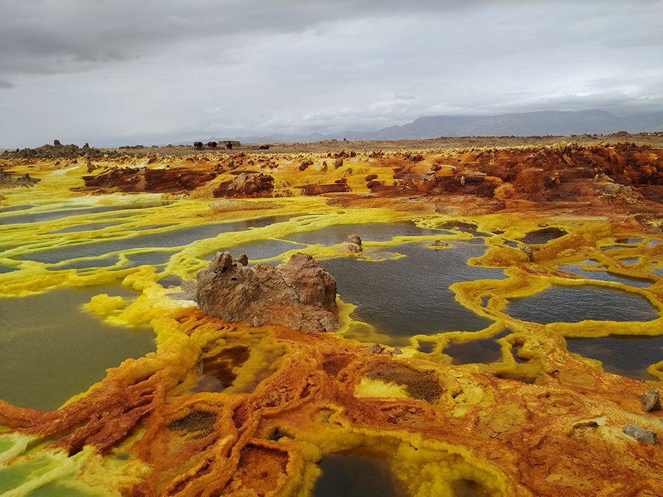
The Danakil depression, with a depth of 116m below sea level, is located in one of the most inhospitable regions of the planet, in the Horn of Africa, between Eritrea, Ethiopia and Djibouti. It is said to be the hottest inhabited place (Afar ethnic group) on the planetWith an average annual temperature of 47ºC, winter is the best time to visit.
The landscape is Martian. An incredible place to enjoy the geological phenomena and the numerous volcanoes. The desert is dotted with salt flats, sulphur springs, sulphur-yellow rocks and pools of steaming water. There are around 30 inactive volcanoes in the area, and one particularly active one, the Erta Ale. Although it seems that the great attraction of this volcano, the pool of lava that could be seen bubbling inside, was practically covered up at the beginning of 2020 as a result of a landslide. Even so, the place is still spectacular.
On the other hand, anthropology enthusiasts will be interested to know that the oldest hominid ever discovered, more than 3 million years old, was found near this site in the Afar Depression.
Trekking in the Rwenzori Mountains and ascent to Margaret Point >>
Type of route: racket-type trekking-climbing. Duration: It usually takes 8-9 days. Best time: January-February and July-August.
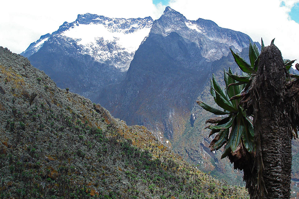
Rwenzori Mountains:
The Rwenzori Mountains o Rwenjura (Rain Mountains), as they are known to the local population, are a mountain range stretching from north to south for 100kms. They are known as the "Mountains of the Moon and was named as early as the 3rd century BC by Ptolemy as the location of the sources of the Nile.
Trekking in the Rwenzori Mountains and ascent to Punta Margarita:
The trekking ascent to Punta Margarita is without any doubt one of the most beautiful treks in the world. This does not make it a tame place, on the contrary, it is a wild route where you will not find the comforts of other routes such as Kilimanjaro or Kenya. The route is demanding. In the lower part you have to cross swampy areas where it is better to walk with plastic wellies than with trekking boots, then mud, a lot of mud and a final ascent on the glacier, where you will need ice axes and crampons, and of course, a good acclimatization to the altitude.
The ascent to Punta Margarita is relatively easy but you will need an ascent permit which is obtained by hiring one of the two companies that share each of the two ascent routes.
From Nyakelengija (Rwenzori Mountaineering Services Company):
- Day 1: Nyakelengija - Nyabitaba Hut.
- Day 2: Nyabitaba Hut - John Matte Hut.
- Day 3: John Matte Hut - Bujuku Hut.
- Day 4: Bujuku Hut - Speke Peak (4,890m) - Bujuku Hut.
- Day 5: Bujuku Hut - Elena Hut.
- Day 6: Elena Hut - Marguerita Peak (5,109m) - Kitandara Hut.
- Day 7: Kitandara Hut - Guy Yeoman Hut.
- Day 8: Guy Yeoman Hut - Nyabitaba Hut - Nyakelengija.
From Kilembe (Rwenzori Trekking Services Company):
- Day 1: Kilembe - Sine Hut.
- Day 2: Sine Hut - Mutinda Camp.
- Day 3: Mutinda Camp - Bugata Hut.
- Day 4: Bugata Hut - Hunwick's Camp.
- Day 5: Hunwick's Camp - Marguerita Camp.
- Day 6: Marguertita Camp - Marguerita Peak (5,109m) - Hunwick's Camp.
- Day 7: Hunwick's Camp - Kiharo Camp.
- Day 8: Kiharo Camp - Kilembe.
Trekking on Mount Kenya (5,199m).
Type of route: trekking-climbing. The most common is to combine different routes up and down, with the circular ring around the top of the mountain, and to climb Lenana Point (4,985m), the highest peak without real difficulties. Duration: about 5 days. Best time: January-February and from the end of August to the end of September.
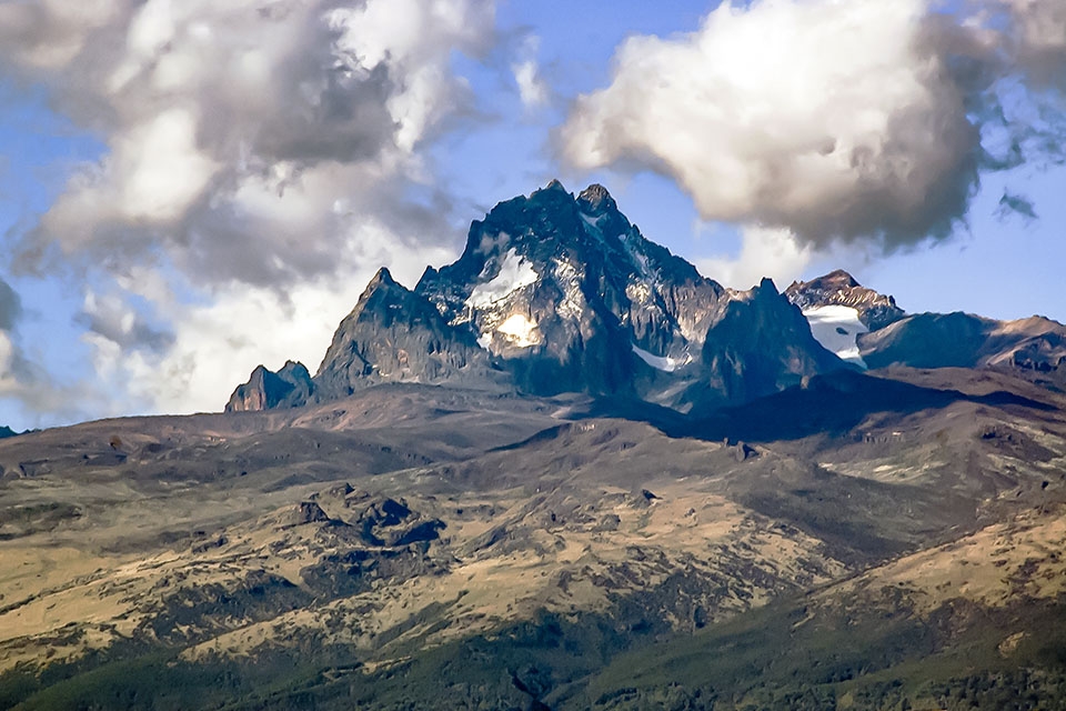
Mount Kenya
The Mount Kenya (5,199m) is the second highest peak in Africa. after Kilimanjaro, 300 km away as the crow flies. The name comes from the Swahili Kere Nyaga (Luminous Mountain) and by contraction Ke-nya, which also gives the country its name.
It is located in the centre of the country, about 150 kilometres from the capital Nairobi and just 16 kilometres south of the equator, which inevitably results in an equatorial climate with unstable weather and two rainy seasons.
Volcanic in origin, the upper part is made up of several alpine peaks and up to 11 glaciers in frank retreat. Like Kilimanjaro, it is an isolated and gigantic mountain. The top is formed by two main peaks, the Batián (5.199m) and the Nelion (5.188m)The climb is not easy, with a climbing grade of IV+, on difficult terrain.
The main trekking routes on Mount Kenya:
To go up to the top of the mountain, inside the National Park, there are 8 main routes with a duration of 2-3 days of ascent. Along these routes we will pass from wet forest and muddy terrain, to the complete absence of vegetation, the realm of rock and glacial relics. Of these 8 routes, the most frequented are three: Chogoria (East), Naro Moru (West) and Sirimon (North).
Whichever route you choose, once at the top, the most common is the circular route to the peak. "Peak Circuit Path and use it as a link between the different uphill and downhill options. This circular route can be done in a single day (10kms and 2000m of ascent), although it is more usual to take 2 or 3 days. The Lenana Point (4.985m)Together with the Austrian and Top refuges, it is the highest peak that can be climbed without climbing and it is enough to carry ice axes and crampons, and sometimes not even that, if there is a good track on the glacier.
Kilimanjaro: Ascent to the Roof of Africa".
Type of route: trekking-climbing. A good idea is to use different routes up and down different slopes. Duration: The Marangu route, the most common route, takes 4 days uphill and 2 days downhill. Best time: January-February and July-October. Outside the rainy periods typical of equatorial climate.
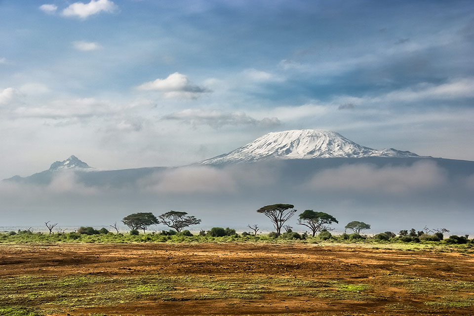
Kilimanjaro:
Kilimanjaro (5,892m) is the highest mountain in Africa. It consists of three volcanoes, two of which are extinct (Shira y Mawenzi) and an inactive one, the Kibo, the highest and most recent one, where the Uhuru PeakThe top of the mountain.
Kilimanjaro is located in TanzaniaA few kilometres from the Kenyan border, on the Great Rift Fault, which is responsible for the volcanic phenomena that have given rise to the highest mountains on the continent: Kilimanjaro, Kenya and Ruwenzori. Kilimanjaro is a stratovolcano of colossal dimensions. A huge volcanic cone (actually three) with a diameter of 90 kilometres, it rises 5000m above the savannah at its feet, at an altitude of only 900m.
Kilimanjaro ascent treks:
The point of departure is usually the airport of NairobiThe trip will be followed by a taxi to Moshi or to the corresponding village, depending on the route chosen. It is estimated that of the 20,000 people who attempt to climb to its summit each year, the 40%The most common causes of failure are problems with altitude and poor physical preparation.
Ascent routes are regulated and it is compulsory to bring a guide and to pay the relevant fees.. In total there are 11 routes and variantsThe most common and easiest are those on the southern slopes.
The most common route is the Marangu route. It has comfortable refuges all along the route and is the oldest and easiest, but also the least spectacular and most crowded. It takes about 4 days to climb and two days to descend.
The other 10 regulated routes are: Rongai Route or Loitokitok Route, Mweka Route, Umbwe Route, Machame Route, Lemosho Route, Shira Route, Great Western Breach Route, Southern Circuit or Summit Circuit Variant, Northern Circuit Variant and Mawenzi and The Saddle Variant.
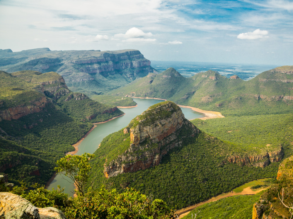
The Blyde River Canyon in South Africa.
Type of route: short routes of less than 10kms. Duration: one or two days are usually taken to see the most famous sites in the canyon. Best time: can be visited at any time of the year.
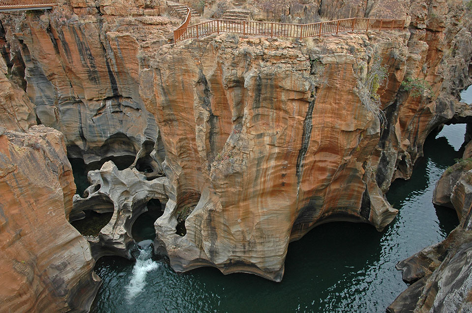
Blyde River Canyon:
North of the Drankensberg massif, at South Africathe second longest canyon on the African continent opens up, the Blyde River Canyonwith an average depth of more than 700m.
Blyde River Canyon Trails
An approach to get to know the canyon can be made by car, driving along the road known as the "canyon of the canyon". "Panorama Route. There are 18 kilometres of road close to the edge of the canyon, where we can visit some interesting places such as the viewpoint at "God's Window and go for a short 1 km walk through the forest, or visit Bourke's Luck PotholesWe can take a 10-kilometre trek (Belvedere Day Walk) to discover a hidden corner where the Treur River meets the Blyde, and contemplate curious forms of fluvial erosion (giant marmites).
Another of the main points of interest is located next to the Forever Blyde Resort, the starting point of several signposted routes (about 7 kilometres long) such as the Leopard trail, Guinea trail o Loerie trailwhich can be combined with each other.
Trekking in the Fish River Canyon in Namibia.
Type of route: linear crossing. Duration: usually takes 4 to 5 days. Best time: Between May and August temperatures are pleasant and the weather is dry. In the austral summer (heat and rain), the canyon is closed for safety reasons.

Fish River Canyon:
The Fish River Canyon is one of the largest canyons in the world, 160 kilometres long and with a maximum depth of 550 metres.
Fish River Canyon Trek:
The part that is the central section, between Hobas and Ai-Ais.. The route runs, depending on the entry point, for 80-90 kilometres through the bottom of the canyon carved out by the river. The route is demandingThe hike is for people who are used to walking and will have to be accustomed to high temperatures. During the 4-5 days it takes to hike, you will have to carry everything you need to survive in there, with little chance of escape. Among the canyon's attractions are the Palm Springs hot springs, the curious rock formations shaped by the water, the wildlife and the many species of birds that inhabit the canyon.
Other places to trek in Africa " : Morocco | South Africa Tanzania |
You may be interested in: The world's most interesting treks and trails".
Fastpacking is not about going faster. It's about going lighter.
If you come from classic trekking, this is the next step: learning to move with less weight,
more fluid and enjoying every kilometre more.
Join the Outsiders Newsletter and start discovering what lightness feels like.