Las mejores rutas de trekking en Grecia
Pirineos y montaña 📩
Aquí 🔥Te puede interesar: Las mejores rutas de Trekking en Europa »
Grecia, Corfú y Creta son un destino especial para practicar trekking, especialmente en primavera y otoño. Las montañas de Grecia, atravesando la cordillera de Pindhos, columna vertebral para este país escarpado, cerca de Atenas, y el Peloponeso, el Monte Olimpo. Aquí el paisaje es a menudo bastante accidentado, salpicado de ruinas, evocador de otra época. Corfú, ofrece una hermosa escapada de la ajetreada costa, con paseos de un día y el sendero de Corfú, que recorre toda la isla.
Guía práctica
¿Cuándo ir?
Junio-Septiembre es el período más estable para el clima, y no muy caluroso en las montañas; nieve Nov-Abril en las montañas.
Zagori: La mejor época para recorrer las rutas es en primavera (finales de mayo a junio) y otoño (septiembre a octubre), cuando el sol y las temperaturas son más suaves y la región más tranquila.
Corfú: La mejor época es de primavera a otoño; todas las caminatas se pueden hacer durante todo el año, pero el alojamiento es más fácil de encontrar de mayo a octubre.
Creta: En teoría todo el año, pero el invierno es invierno y el verano puede ser muy caluroso. La primavera y el otoño son las épocas más atractivas.
Ciudades & Servicios
Karpenísi, Métsovo, Ámfissa, Trípoli, Dhíakhofto, Sparta, Áyios Nikólaos
Zagori: Kipi, Dilofo, Tsepelovo, Monodendri, Elafotopos, Papigo, Konitsa, Pades, Metsovo, Vovousa
Corfú: Ciudad de Corfú, Agios Georgios norte y sur, Aharavi, Barbati, Benitses, Kalami, Kavos, Liapades, Paleokastritsa, Paramonas, Pelekas
Creta: Chania, Rethymnon, Heraklion, Hora Sfakion
No te puedes perder
Atraviesa los Pindos, el Monte Olimpo, el Monte Khelmós, el Monte Párnonas, hermosos paisajes, rica flora e interés cultural.
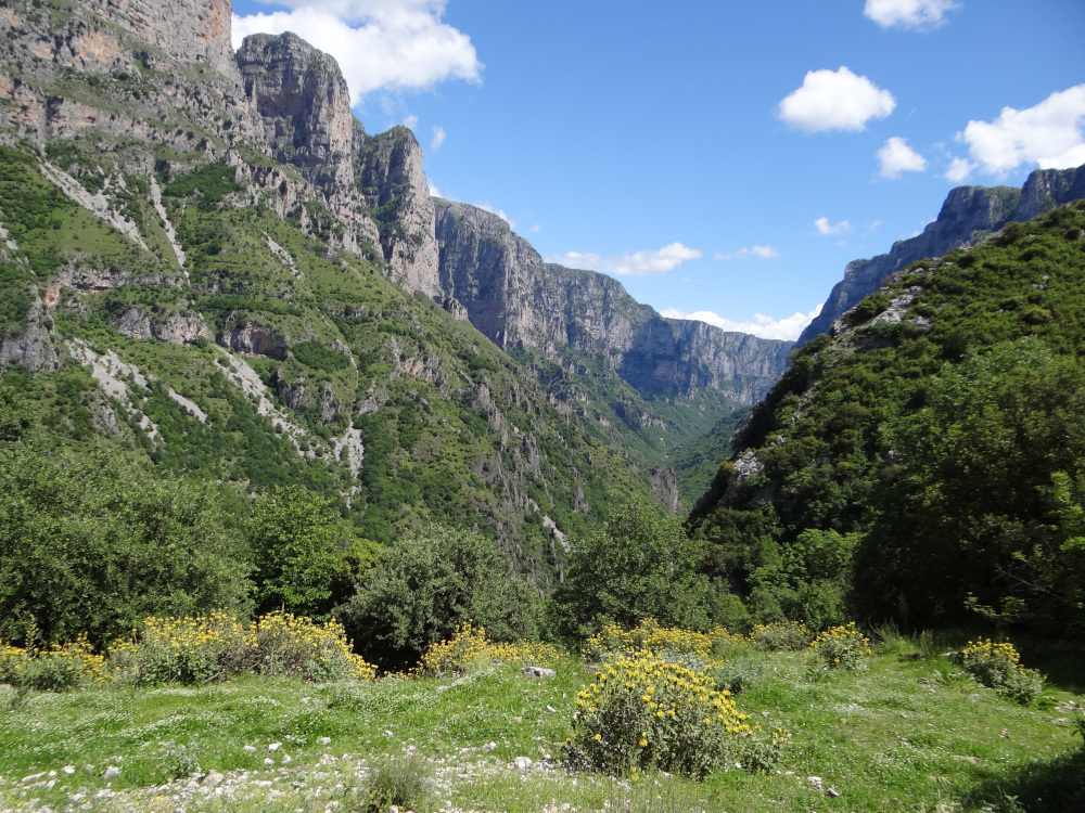
Zagori: El desfiladero de Vikos; pueblos pintorescos con una arquitectura única; impresionantes puentes de piedra del siglo XVIII y una red de senderos empedrados; lagunas alpinas de Drakolimni (también conocidas como Dragonlakes); oportunidades para hacer rafting en el río Voidomatis; impresionantes paisajes montañosos; el místico Parque Nacional de Valia Calda.
Corfu: la montaña Pandokratoras de 911m en el noreste, un vasto macizo de piedra caliza que mira hacia la costa albanesa y domina impresionantes tramos de costa; hermosas playas de arena dorada en la costa oeste de la isla; Paleokastritsa y sus bellas bahías; la fortaleza de Angelokastro; Cabo Drastis y Porto Timoni.
Creta: En las Montañas Blancas, el famoso desfiladero de Samaria. Psiloritis (Monte Ida), la cima de la isla en el centro de Creta y el Monte Dikti en el este de Creta.
El Camino del Peloponeso
El Camino del Peloponeso atraviesa la península del Peloponeso desde Dhiakoftó en el norte hasta la playa de Pantazí en el sur, pasando por Trípoli. Con praderas alpinas, un espectacular desfiladero y laderas cubiertas de bosques, la ruta de 220 km se puede recorrer a pie en unos quince días.
- Tramo 1 Dhiakoftó a Trípoli
- Etapa 1 Dhiakoftó – Monasterio de Méga Spílio
- Etapa 2 Méga Spílio hasta Áno Lousí
- Etapa 3 Áno Lousí – Tourládha
- Etapa 4 Cerca de Tourládha a Dhára
- Etapa 5 De Nimfasía a Vitína
- Etapa 6 Vitína a Kardharás o Kápsia
- Etapa 7 Kardharás o Kápsia a Trípoli
- Tramo 2 Trípoli-Pantazí
- Etapa 8 Psilí Vrísi a Áyios Pétros
- Etapa 9 Convento de Malevís a Vamvakoú
- Etapa 10 Vamvakoú-Paleogoulás
- Etapa 11 Mistrás a Anavrití
- Etapa 12 Anavrití – Refugio de montaña de Taïgetos
- Etapa 13 Refugio de montaña Taïgetos a Árna
- Etapa 14 Árna – Playa de Pantazí
La ruta de los Píndos
La ruta de los Pindos, de 460 km de longitud, es una travesía sur-norte de la columna vertebral de las montañas griegas, que puede recorrerse en un mes o dividirse en tramos de aproximadamente una semana. Con un terreno remoto, un desafío de navegación y menos instalaciones en la ruta, es el más difícil de los cuatro trekkings, pero ofrece una oportunidad única de experimentar tanto la vida silvestre del país como la vida montañosa tradicional.
- Tramo 1 De Ámfissa a Karpenísi
- Etapa 1 Ámfissa – Barranco de Víniani y Reká
- Etapa 2: Mt Ghióna: Refugio de Víniani a Láka Karvoúni
- Etapa 3 Refugio Láka Karvoúni a Sikiá
- Etapa 4 Sikiá a Athanásios Dhiákos/Áno Mousounítsa
- Etapa 5: Monte Vardhoúsia: Athanásios Dhiákos/Áno Mousounítsa al redil de Yiourtáki
- Etapa 6, rebaño de ovejas Yiourtáki hasta el refugio del monte Oxiá/Sarádena
- Etapa 7 Refugio del Monte Oxiá/Sarádena al obelisco de Kokália/Rákhes Timfristoú
- Etapa 8 Obelisco de Kokália/Rákhes Timfristoú a Karpenísi
- Tramo 2 Karpenísi-Mesokhóra
- Etapa 9 Karpenísi – Kerasokhóri
- Etapa 10 Kerasokhóri – Varvariádha
- Etapa 11 Varvariádha – Epinianá
- Etapa 12 Epinianá – Monasterio de Spiliá
- Etapa 13 Monasterio de Spiliá a Petrotó
- Etapa 14 Petrotó hasta Kalí Kómi
- Etapa 15 Kalí Kómi a Moskhófito
- Etapa 15A Kalí Kómi hasta Mirófilo
- Etapa 16 De Moskhófito a Mesokhóra
- Etapa 16A Mirófilo a Mesokhóra
- Tramo 3 Mesokhóra-Métsovo
- Etapa 17 Mesokhóra hasta Gardhíki o Athamanía
- Etapa 18 Gardhíki o Athamanía hasta Matsoúki
- Etapa 19 Matsoúki – Kalarítes
- Etapa 20A Ruta de Kalarítes a la cresta de Khalíki
- Etapa 21 Khalíki – Métsovo
- Tramo 4 Métsovo a la frontera albanesa
- Etapa 22 Métsovo – Vália Kálda
- Etapa 23 Vália Kálda – Vovoúsa
- Etapa 24 Vovoúsa – Dhístrato
- Etapa 24A Enlace: Ferry de Vovoúsa a Skamnéli
- Etapa 25 Dhístrato a Samarína
- Etapa 25A Dhístrato a Palioséli
- Etapa 26 Samarína – Dhrakólimni
- Etapa 26A Palioséli – Dhrakólimni
- Etapa 27 Dhrakólimni a Ayía Paraskeví/Kerásovo
- Etapa 28 Ayía Paraskeví/Kerásovo a Kefalokhóri
- Etapa 29 Kefalokhóri – Aetomilítsa/Dénsko
- Etapa 30 Aetomilítsa/Dénsko hasta la cumbre del monte Grámos
Montañas del norte de Pindos: Zagóri
Zagori, en el Parque Nacional de los Pindos del Norte de Grecia, es uno de los últimos destinos de senderismo relativamente desconocidos y vírgenes de Europa. Esta guía presenta una selección de treinta caminatas y tres trekkings cortos que muestran el cautivador paisaje de la región, desde dramáticas gargantas hasta místicos bosques, ríos cristalinos de color turquesa, escarpados picos alpinos y característicos pueblos de montaña. Las rutas varían desde caminatas fáciles por senderos despejados hasta ascensos extenuantes y travesías de montaña, lo que significa que hay algo que se adapta a la mayoría de las ambiciones y habilidades.
Desde paseos fáciles hasta exigentes caminatas a lo largo de remotas travesías montañosas, incluidos los escarpados picos del monte Timfi y el monte Smolikas en la cordillera de Pindos, el lago Drakolimni y el espectacular desfiladero de Vikos.
Trekking Zagóri y Mt Gamíla
Se puede disfrutar de una caminata Zagóri más corta de 80 km. por derecho propio o incorporada al Camino de Pindos.
- Etapa 1 Tsepélovo a Kípi vía Kapésovo y Koukoúli
- Etapa 1A De Tsepélovo a Kípi por el puente de Khadzíou
- Etapa 2 Kípi a Monodhéndhri
- Etapa 3 Monodhéndhri a Pápingo por el desfiladero de Víkos
- Etapa 4 Pápingo – Refugio Astráka
- Etapa 5 Refugio Astráka a Tsepélovo o Kapésovo
- Etapa 5A Refugio Astráka a Kónitsa
- Etapa 6 Skamnéli a Kónitsa
Excursiones en Zagori
Las rutas se organizan por zonas, que abarcan el centro de Zagori, el desfiladero de Vikos y sus alrededores, el monte Timfi, Konitsa y el monte Smolikas, y el Parque Nacional de Valia Calda y Metsovo, con puntos destacados como el monte Timfi y el monte Smolikas (la segunda montaña más alta de Grecia), el impresionante desfiladero de Vikos, los puentes tradicionales de arco de piedra y los alquitranes alpinos de Drakolimni (Dragonlakes). Con tantos paisajes impresionantes, esta es una región que clama por ser explorada.
Zagori Central
- La ronda de los puentes de piedra
- Kipi a Dilofo y Vitsa
- Kipi hasta Kapesovo y el puente de Missios
- Kipi a Tsepelovo y Kapesovo
- Escalera Vradeto y mirador de Beloi
- Ruta por el desfiladero de Vikaki (Selato)
- Mt Mitsikeli
- Cascadas de Iliochori
El desfiladero de Vikos y sus alrededores
- Cruce del desfiladero de Vikos
- Mirador de Oxia
- Voidomatis Springs y Monasterio de Theotokos
- Travesía del desfiladero de Voidomatis
- Mirador Kokkino Lithari
- Pueblos de Papigo y piscinas naturales de Ovires Rogovou
- Un enfoque alternativo al desfiladero de Vikos
Mt Timfi
- Refugio Astraka y Lago Drakolimni
- Lago Robozi
- Cumbre de Gamila
- Cumbre de Astraka
- La ronda de Astraka
- El sendero Davalista (Refugio Astraka a Konitsa)
- Refugio Astraka a Konitsa o Vrisochori por el Paso Karteros
- Tsepelovo a la travesía de Vrisochori
- El último trekking en Zagori
Konitsa y el Monte Smolikas
- Mt Trapezitsa y Roidovouni Peak
- Monasterio Stomiou
- Konitsa hasta la travesía de Vrisochori
- Pades hasta Drakolimni del Lago Smolikas
- El clásico ascenso al Dragonlake de Smolikas
Parque Nacional Valia Calda y Metsovo
- Parque Nacional Valia Calda
- Pico Avgo
- Los Lagos Flega
- Siguiendo las huellas del oso pardo en Metsovo
Mt Olympus
Esta ruta explora el Monte Olimpo, hogar de los antiguos dioses del mito griego y la montaña más alta de Grecia.
- Etapa 1 Priónia a Spílios Agapitós/Refugio A
- Etapa 2 Spílios Agapitós/Refugio A a Mítikas y Yiósos Apostolídhis/Refugio B
- Etapa 3 Yiósos Apostolídhis/Refugio B a Priónia
- Etapa 4 Priónia a Litókhoro
Corfú
Corfú es la más verde de las islas jónicas y una de las más accesibles, por lo que es un gran destino para unas vacaciones a pie. Con playas de arena dorada en la costa oeste, la espectacular fortaleza de Angelokastro, espectaculares acantilados en el Cabo Drastis y las calas gemelas de Porto Timoni, estos paseos evitan los complejos turísticos abarrotados y permiten al caminante experimentar la atmósfera relajada y los variados paisajes naturales de esta hermosa isla.
Los paseos empiezan en varios destinos turísticos populares de la isla, como Corfú, Kalami, Paleokastritsa, Agios Georgios al norte y al sur, Liapades y Benitses. Los paseos de un día se extienden por toda la isla y visitan olivares, senderos costeros, playas de arena, exuberantes y verdes laderas y pintorescos pueblos. El sendero de Corfú recorre la isla desde Kavos hacia el norte hasta Agios Spyridonas. Los paseos son aptos para todos los niveles y se pueden realizar durante todo el año.
El noreste de Corfú
- Kaminaki hasta el sendero costero de Kerasia
- Kalami hasta Menegoulas
- El antiguo sendero de Perithia
- Excursión alrededor del Cabo Agia Ekaterinis
- El Sendero Panorámico por encima de Aharavi
El noroeste de Corfú
- Cabo Drastis
- Agios Stefanos hasta Arillas
- Porto Timoni
- Cabaña del Pescador y el kalderimi
- Ruta Paleokastritsa y Angelokastro
- Playa de Limni
- Playa de Liniodoros
Centro de Corfú
- Mirtiotissas y montaña Agios Georgios
- Agii Deka
- Benitses hasta Dafnata
- Agios Mattheos y Prasoudi
Sur de Corfú
- Circuito del lago Korission
- Ruta del Lago Corto de Korission
- Excursión Chlomos
- Las Salinas de Lefkimmi
- Circuito de la playa de Arkoudilas
- La curva corta de Arkoudilas
El sendero de Corfú
El sendero de larga distancia de Corfú de 150 km, se afronta en 10 etapas, comenzando cerca de Kavos, en el extremo sur de la isla, y terminando en Agios Spiridonas, su promontorio norte, que abarca largas playas de arena, tranquilos pueblos de montaña, exuberantes valles y las magníficas costas rocosas. Cada etapa termina en un pueblo o playa donde hay comida y alojamiento.
- Etapa 1 De Kavos a Potami
- Etapa 2 Potami a Agios Georgios sur
- Etapa 3 Agios Georgios sur hasta Paramonas
- Etapa 4 Paramonas a Dafnata
- Etapa 5 De Dafnata a Pelekas
- Etapa 6 Pelekas a la playa de Liapades
- Etapa 7 Playa de Liapades a Agios Georgios norte
- Etapa 8 Agios Georgios norte a Sokraki
- Etapa 9 Sokraki a la antigua Perithia
- Etapa 10 Perithia Antigua a Agios Spiridonas
Creta: Las Montañas Blancas, Psiloritis y Lassithi
Creta ofrece una amplia gama de paisajes y desafíos para los excursionistas, con sus espectaculares gargantas y sus numerosas cumbres que superan los 2.100 m, sus llanuras de alta montaña, sus peñascos boscosos, sus acantilados masivos y sus playas remotas. Una combinación del clima y sus antiguos sitios históricos hacen de la isla griega de Creta un gran destino para explorar a pie.
Todas las cadenas montañosas de Creta presentan altas llanuras, barrancos y barrancos, pero en el corazón de la Lefka Ori hay algo más. En lo alto de la línea de árboles, la nieve se descongela en julio para revelar un gran círculo de picos estériles masivos, intercalados con afloramientos de «paisaje lunar», o depresiones, de agujeros en roca negra, gris o roja. Este desierto alto y salvaje es raramente visitado, pero cubre unos 960 km2.
En el centro de Creta, donde la isla es más ancha, la enorme masa de Psiloritis (Monte Ida) domina toda la región. Con una superficie de unos 560 km2, este macizo se diferencia de los demás por el hecho de que, por un lado, se eleva una enorme cresta de la cima, parcialmente asfaltada, que se eleva por encima de enormes acantilados y, por el otro, una gran superficie de picos más bajos y estribaciones boscosas. La cima del Monte Ida, a 2456m es el punto más alto de Creta. Ofrece varias rutas de senderismo lineales desafiantes, incluyendo el alto nivel de la llanura de Nida.
Las montañas de Lassithi cubren unos 780 km2 y prácticamente dividen el centro de Creta del extremo oriental de la isla. No sólo es la mayor de las llanuras de alta montaña, sino también la mayor zona llana de Creta. A unos 820 m de altitud, tiene forma ovalada, más de 9 km de longitud en dirección oeste-este y 5 km de norte a sur.
En Creta, la E4 comienza en Kastelli y recorre varios de los sitios arqueológicos menos visitados en su viaje hacia el este. Aunque el sendero principal sigue la espina dorsal montañosa de Creta, las ramas cretense de la Asociación Alpina Helénica también han designado una buena ruta `variaciones’, ya sea a lo largo de la costa, o como ramas que conducen al sendero principal.
Las Montañas Blancas (Lefka Ori)
La Llanura de los Omalos
- Alrededor de la llanura de Omalos
- El desfiladero del Parque Nacional de Samaria
- El Ascenso de Gingilos
- Xyloscala hasta el Refugio Kallergi
- Refugio Kallergi a Melendaou
- Xyloscala a Koustoyerako a través de Strifomadi
- Koustoyerako a Xyloscala por Strifomadi.
- Omalos a Koustoyerako vía Ay. Capilla de Theodoros
- Koustoyerako hasta Omalos vía Ay. Capilla de Theodoros
- Omalos a Ay. Barranco de Irini
- Ay. Desfiladero de Irini a Souyia
- Souyia a Lissos y Paleochora (E4 Trail)
- Omalos a Zourva
- Zourva hasta Omalos
- Zourva a Meskla
- Omalos a Lakki y Meskla
- Lakki hasta Omalos
Las Estribaciones del Norte
- Kambi al Refugio Volikas
- Kambi a Melidoni
- Melidoni hasta Kambi
- Kares a Gournes
- Melidoni a Fresco
- Fresco a Vrisses
- Fresco a Vafes vía Tzitzifes
- Melidoni a Vafes vía Vothanas
- Vafes a Melidoni vía Vothanas
- Vafes a Vrisses
- Vrisses a Vafes
- Vafes hasta Askifou
La llanura de Askifou
- Alrededor de la llanura
- Askifou a Imbros
- El desfiladero de los Imbros
- Kommitades hasta Hora Sfakion
- El desfiladero de Asfendou desde Askifou
- Askifou-Goni a Kallikratis
- El desfiladero de Kallikratis
- Askifou-Ammoudari a Niato (Sendero E4)
- El ascenso del Kastro
- Askifou a Imbros por Trikoukia
- Askifou a Anopolis (o Hora Sfakion) vía Kali Lakki
- Askifou a Vafes
- Krappis hasta el lago Kourna
Anopolis
- Anopolis a Loutro
- Kambia a Loutro
- Kambia hasta Anopolis o Ay. Ekaterini
- Kambia hasta Hora Sfakion
- Anopolis a Aradena
- El desfiladero de la Aradena
- Aradena hasta Ay. loannis y Sellouda
- Aradena hasta Ay. Roumeli vía Sellouda
- El bosque de Aradena y Kroussia
- Anopolis a Askifou vía Kali Lakki
La costa sur de Sfakia
- Hora Sfakion a Loutro (E4 Trail)
- Hora Sfakion hasta Anopolis
- Hora Sfakion a Mouri
- Loutro a Livaniana y más allá
- Loutro hasta Ay. Roumeli (Sendero E4)
- El desfiladero del Parque Nacional de Samaria
- alrededor de Ay. Roumeli
- La garganta de Eligias, Angelokampi y fortalezas turcas
- Ay. De Roumeli a Anopolis por Sellouda
Trekkings
- 1 Theriso a Livada vía Kolokithas
- 1A Livada a Theriso
- 2 Kambi a Livada vía Refugio Volikas EOS
- 2A Livada a Kambi
- 3 Askifou a Livada vía Niato y Grias Soros (E4 Trail)
- 3A Livada a Niato y Askifou (E4 Trail)
- 4 Livada a Katsiveli (Sendero E4)
- 4A Katsiveli a Livada (E4 Trail)
- 5 Katsiveli a Potamos (Sendero E4)
- 5A Potamos a Katsiveli
- 6 Omalos (o Refugio Kallergi) a Potamos (y Katsiveli) vía Melendaou (E4 Trail)
- 6A Potamos al Refugio Kallergi (E4 Trail)
- 7 Potamos a Ay. Ioannis via Zaranokefala
- 7A Ay. De Ioannis a Potamos vía Zaranokefala
- 8 Anopolis a Katsiveli
- 8A Katsiveli hasta Anopolis
El ascenso de Pachnes
- 9 Roussies a la cumbre de Pachnes
- 9A Pachnes cumbre a Katsiveli
- 9B Katsiveli a la cumbre de Pachnes
La costa sur
- 10 Ay. De Roumeli a Souyia (E4 Trail)
- 10A Souyia hasta Ay. Roumeli (Sendero E4)
Psiloritis (Monte Ida)
- Anoyeia a la taberna Nida
- Zaros a Ay. Capilla de Ioannis Rouvas por el desfiladero de Rouvas
- Ay. Capilla de Ioannis a la llanura de Nida (E4 Trail)
- Kamares a la Cueva de Kamares
- Paseo por la cueva Kamares hasta la llanura de Nida
- Kamares hasta la cima del Monte Ida
- El monasterio de Arcadi a Aravanes Kampos
- Aravanes Kampos a la llanura de Nida
- Lakkos Mygerou (Livadia) hasta la cima del Monte Ida
- Aravanes Kampos hasta el Refugio EOS Toubotos Prinos
- El Valle del Amari: Fourfouras y Kouroutes
La llanura de Nida
- Nida hasta la cima del Monte Ida (E4 Trail)
- Cima del Monte Ida: descenso a Kamares
- Nida hasta Anoyeia por la E4 Trail
- Nida hasta Anoyeia por Old Droving Trail
- Nida hasta Ay. Capilla de Ioannis (Sendero E4)
- Nida a Kamares a través de la cueva Kamares
- Nida hasta el monasterio de Arcadi
Las montañas de Lassithi (Dikti)
- Kastamonitsa hasta Ay. Georgios (Sendero E4)
- Ay. Ferry de Georgios a Tzermiado
- A Tzermiado hasta Ay. Georgios
- Tzermiado a Karphi y vuelta
- Ay. Georgios a la llanura de Katharo y viceversa
- Ay. Georgios (para la cumbre del Monte Dikti) hasta Selakano (E4 Trail)
- Selakano hasta Ay. Georgios (Sendero E4)
- Selakano hasta la llanura de Katharo (para Lassithi o Kritsa)
- Katharo Plain por la carretera del borde sur hasta Selakano
- Katharo Plain hasta Kritsa (para Ay. Nikolaos)
- Kritsa hasta la llanura de Katharo
- Magoulas a Xeniakos y Ano Viannos
Los lugares más impresionantes de Grecia para practicar Trekking y montañismo:
- Marino de Alónnisos
- Vikos-Aoös