Download the track


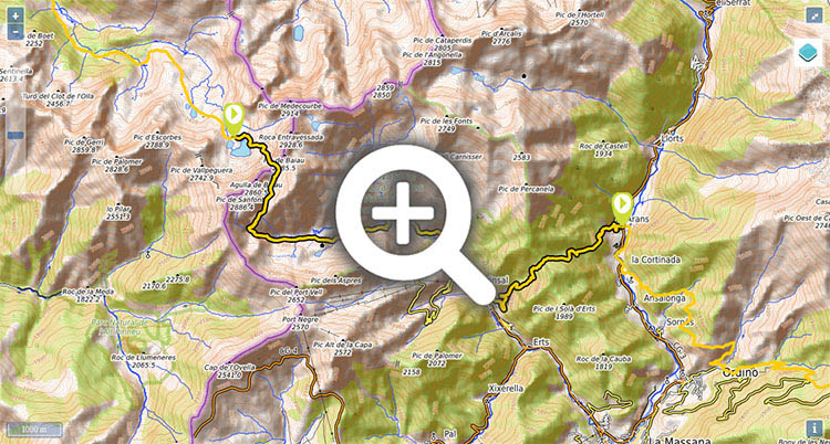
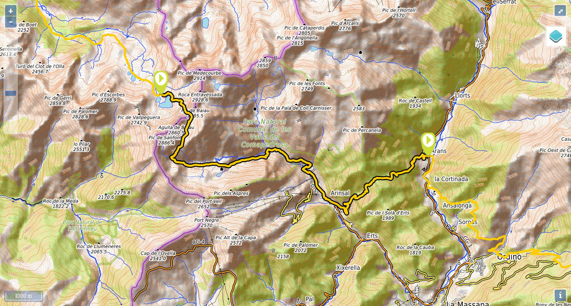
Stage 31: Refugio de Baiau - Arans


Distance/elevation: 14,9 kms / (+810),(-1.920)
Tiempo: 6h25min (walking time without stops).
Difficulty: in early summer the use of an ice axe and crampons may be required at the Port de Baiau.
Agua: there are several streams along the way.
Suggestions: from Port de Baiau, it is possible to climb the Pic de Coma Pedrosa summit, the crowning point of the Principality of Andorra, in 30mins.

Route/Itineparary:

(0h00min; 0 kms) Refugio de Baiau o Josep María Montfort (2.517m).Walk down to Estany de Baiau lake and walk around it on the left, until you stand below Pico de Baiau peak, ignoring a path that climbs up to Collada dels Estanys Forcats. The path heads up through boulders, crosses a creek where you can fill up with water, and continues on a steep climb. Crampons may be obligatory in early summer.

(1h00min; 1,4 kms) Port de Baiau (2.757m). You are entering Andorra. The Pyrenees trail heads south down into the valley.

(1h20min; 2,1 kms) Estany Negre (2.640m). Walk around it on the left and keep walking downhill to the Basses d'Estany Negre which you also skirt on the left-hand side. The valley eventually opens out into the main valley of Coma Pedrosa. The path descends quickly, along the valley floor, passing the crossing to Coma Pedrosa mountain refuge, before reaching the...

(2h30min; 4,6 kms) Collet de Coma Pedrosa (2.224m). From this point the path descends decisively. At about 1,750m altitude, you join a wider path that converges with the GR11-1 variant and the Gran Recorrido GRP trails (Andorra circular walk) and GRT (3 Nations). A panel welcomes you to the Parc Natural Comunal de les Valls del Comapedrosa. Continue downhill, past a deposit, until you reach the first buildings of Arinsal. Cross a road tunnel, and on the other side you will find a tourist information point. Follow the road towards the centre of the village.

(4h15min; 9,5 kms) Arinsal (1.480m). At a roundabout in the centre, there is a road leading to Mas Ribafeta. Follow this road until, after a couple of hairpin bends, on a wide bend on the right, appears a very steep path that climbs without respite up to the...

(5h30min; 12,2 kms) Coll de les Cases (1.954m). The walk down the other side, through pine woodland, is also very steep, and soon brings you to...

(6h25min; 14,9 kms) Arans (1.370m).

Maps:

- Alpina: Andorra (Scale: 1/40.000).
- Rando editions: Andorra - Cadí (Scale: 1/50.000).

Where to sleep:

At the beginning of the stage, Baiau or Josep María Montfort shelter (free, 9 places, blankets).

During the stage, you have the Refugio de Comapedrosa (/).

In Arinsal there is a choice of accommodation, we recommend: Hotel Comapedrosa (Tel: (+34) 376 737 950; hotelcomapedrosa@live.com) and Hotel Arinsal (Tel: (+37) 683 88 89/ (+37) 683 58 42 / (+37) 634 49 47; hotelarinsal@hotelarinsal.com), both with restaurant.

At the end of the stage, in Arans we recommend Apartamentos Arans 3000 (Tel: +34 976 10 13 32; booking@apartamentos3000.com).


Perfil de la etapa

Stages - GR11

- Prologue: Cabo Higuer - Hondarribia - Irun
- Stage 1: Cabo Higuer - Bera
- Stage 1v (GR 11.3): Cabo Higuer - Lesaka
- Stage 2: Bera - Elizondo
- Stage 2v (GR 11.3): Lesaka - Elizondo
- Stage 3: Elizondo - Pto de Urkiaga
- Stage 4: Puerto de Urkiaga - Burguete
- Stage 5: Burguete/Auritz - Villanueva de Aezcoa/Hiriberri
Stage 6: Villanueva de Aezcoa/Hiriberri - Ochagavia
Stage 7: Ochagavia - Isaba
Stage 8: Isaba - Zuriza (via Belabarce)
Stage 8v (GR 11.4): Isaba - Zuriza (via Ezkaurre)
Stage 9: Zuriza - Aguas Tuertas
Stage 10: Aguas Tuertas - Lizara
Stage 10 (discontinued): Aguas Tuertas - Candanchú
Stage 11: Lizara - Candanchú
Stage 12: Candanchú - Sallent de Gallego
Stage 9v (GR 11.1): Zuriza - Puente de Santa Ana
Stage 10v (GR 11.1): Puente de Santa Ana - Lizara
Stage 11v (GR 11.1): Lizara - Canfranc Estación
Stage 12v: Canfranc Estación - Sallent de Gallego (via C.Izas)
Stage 13: Sallent de Gallego - Refugio de Respomuso
Stage 14: Refugio de Respomuso - Balneario de Panticosa
Shortcut: The pipeline path from Bachimaña to Brazato
Stage 15: Balneario de Panticosa - San Nicolas de Bujaruelo
Stage 16: San Nicolas de Bujaruelo - Refugio de Goriz
Stage 17: Refugio de Goriz - Circo de Pineta (Fuenblanca)
Stage 17v (GR11.9): Refugio de Goriz - Circo de Pineta (Faja de las Olas)
Stage 18: Circo de Pineta - Parzán
Stage 19: Parzán - Biadós
Stage 20: Biadós - Puente de San Jaime
Stage 20v (GR 11.2): Biadós - Ref. Ángel Orús
Stage 21v (GR 11.2): Ref. Ángel Orús - Puente de San Jaime
Stage 21: Puente de San Jaime - Refugio de Cap de Llauset
Stage 21v (GR 11.5): Puente de San Jaime - Refugio de la Renclusa
Stage 22v (GR 11.5): Refugio de la Renclusa - Refugio de Cap de Llauset
Stage 22: Ref. Cap de LLauset - Conangles
Stage 23: Conangles - La Restanca
Stage 24v (GR11.18): La Restanca - Colomers
Stage 25: Colomers - Ernest Mallafré
Stage 26: Ernest Mallafré - La Guingueta
Stage 27: La Guingueta - Estaón
Stage 28: Estaón - Tavascán
Stage 29: Tavascán - Areu
Stage 30: Areu - Baiau
Stage 31: Baiau - Arans
Stage 32: Arans - Encamp
Stage 33: Encamp - Ref. l'Illa
Stage 34: Ref. l'Illa - Malniu
Stage 35: Malniu - Puigcerdá
Stage 36: Puigcerdá - Planoles
Stage 37: Planoles - Santuario de Nuria
Stage 38: Santuario de Nuria - Refugio de Ulldeter
Stage 39: Refugio de Ulldeter - Molló
Stage 40: Molló - Talaixà
Stage 41: Talaixà - Albanyà
Stage 42: Albanyà - La Vajol
Stage 43: La Vajol - Requessens
Stage 44: Requessens - Vilamaniscle
Stage 45: Vilamaniscle - El Port de la Selva
Stage 46: El Port de la Selva - Cap de Creus


Selección: Piolets
Petzl
Glacier Literide
320grs (50cms)
Grivel
Nepal S.A.
440grs (58 cm)
Salewa
Tour-X Pro
470grs (55cms)


Map of the stage