Download the track


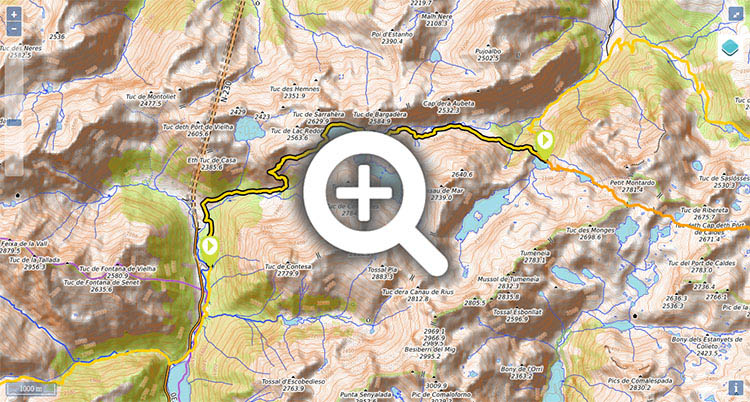
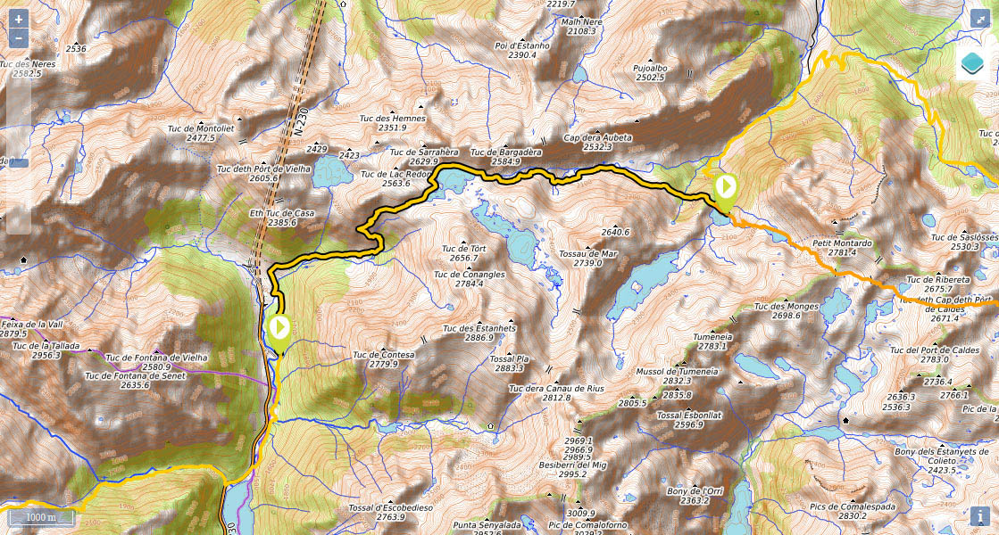
Stage 23: Refugi de Conangles - Refugi dera Restanca


Distance/elevation: 11,7 kms / (+908m),(-467m)
Time: 4h45min (walking time without stops).
Difficulty: a short stage without excessive elevation, mostly along paths. Waymarking is good throughout the stage, apart from the last part of the climb to La Restanca.
Water: throughout the stage there are a number of streams and lakes where you can fill up with water.
Suggestions: A magnificent alternative, adding a little more than an hour to the stage, is to follow the ARP passing Estany Tort de Rius and Estany de Mar, to rejoin the main route at the end of the stage at La Restanca.
Route/Itinerary:

(0h0min;0km) Refugi de Conangles (1.555m). The GR11 follows the path that leads to the refuge towards the north, crossing the Conangles fir forest. After 1km you pass by a gravel pit and cross over a creek. After 400m you will reach a crossing with a wooden signpost, meeting the ARP Pyrenees upland route (unmarked). Keep right, heading up the Conangllos/Conangles valley, until at around 1,900m altitude, the path veers left (north) and zigzags uphill to...

(2h15min; 5.3kms) Port de Rius (2.355m). Keep walking towards Rius lake – at the head of Rius valley – and walk round the left-hand side of it to the point where it runs off. At this point the ARP (possible variant) peels off from the GR11. Keep walking down Rius valley, passing a spring (5') where you can get water (in early August it wasn’t dry) and continue until just before Plan de Rius (small lake), with the first trees up ahead. At around 1,960m altitude leave the path that heads into the bottom of the valley (GR211- Val d'Aran circular route) and keep right, along a path that runs half-way up.

The main GR11 route heads down towards Rius cabin and crosses Rius valley as far as Plan de Nera, where the next day it rejoins in Colomers across Port de Ribereta. The route we describe via La Restanca refuge and stage 23, is the variant GR11.18 which in our view is more interesting that the main route.

The path now heads into the forest, where it becomes a bit unclear, then climbs up to a kind of shoulder, from which point you can make out the dam and the refuge.

(4h45min; 12kms) Refugi dera Restanca (2.010m).

Where to sleep:

At the beginning of the stage, Refugi de Conangles (/).

At the end of the stage, Refugi dera Restanca (/).
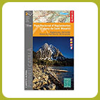
Maps:

- Alpina: Parc Nacional d'Aigüestortes i Stany de Sant Maurici (Scale: 1/25.000).

Transport:

Several buses stop at the Conangles car park every day. The Aigües Tortes Park bus Tortes Alsa is in service throughout the summer and is ideal for treks across the park. It completes an almost circular route of the Park with 2 daily services in one direction and 2 in the other. The bus coming from Barcelona or Lleida also stops at the car park (several per day), and this service is managed by Alsa.

Activities in the area:

In Aigües Tortes a hugely popular walk is the Carros de Foc traverse (a circular route that links all 9 of the National Park’s refuges). In Val d'Aran the Setau Sagèth circular walk is also very well-known.


Perfil de la etapa

Stages - GR11

- Prologue: Cabo Higuer - Hondarribia - Irun
- Stage 1: Cabo Higuer - Bera
- Stage 1v (GR 11.3): Cabo Higuer - Lesaka
- Stage 2: Bera - Elizondo
- Stage 2v (GR 11.3): Lesaka - Elizondo
- Stage 3: Elizondo - Pto de Urkiaga
- Stage 4: Puerto de Urkiaga - Burguete
- Stage 5: Burguete/Auritz - Villanueva de Aezcoa/Hiriberri
Stage 6: Villanueva de Aezcoa/Hiriberri - Ochagavia
Stage 7: Ochagavia - Isaba
Stage 8: Isaba - Zuriza (via Belabarce)
Stage 8v (GR 11.4): Isaba - Zuriza (via Ezkaurre)
Stage 9: Zuriza - Aguas Tuertas
Stage 10: Aguas Tuertas - Lizara
Stage 10 (discontinued): Aguas Tuertas - Candanchú
Stage 11: Lizara - Candanchú
Stage 12: Candanchú - Sallent de Gallego
Stage 9v (GR 11.1): Zuriza - Puente de Santa Ana
Stage 10v (GR 11.1): Puente de Santa Ana - Lizara
Stage 11v (GR 11.1): Lizara - Canfranc Estación
Stage 12v: Canfranc Estación - Sallent de Gallego (via C.Izas)
Stage 13: Sallent de Gallego - Refugio de Respomuso
Stage 14: Refugio de Respomuso - Balneario de Panticosa
Shortcut: The pipeline path from Bachimaña to Brazato
Stage 15: Balneario de Panticosa - San Nicolas de Bujaruelo
Stage 16: San Nicolas de Bujaruelo - Refugio de Goriz
Stage 17: Refugio de Goriz - Circo de Pineta (Fuenblanca)
Stage 17v (GR11.9): Refugio de Goriz - Circo de Pineta (Faja de las Olas)
Stage 18: Circo de Pineta - Parzán
Stage 19: Parzán - Biadós
Stage 20: Biadós - Puente de San Jaime
Stage 20v (GR 11.2): Biadós - Ref. Ángel Orús
Stage 21v (GR 11.2): Ref. Ángel Orús - Puente de San Jaime
Stage 21: Puente de San Jaime - Refugio de Cap de Llauset
Stage 21v (GR 11.5): Puente de San Jaime - Refugio de la Renclusa
Stage 22v (GR 11.5): Refugio de la Renclusa - Refugio de Cap de Llauset
Stage 22: Ref. Cap de LLauset - Conangles
Stage 23: Conangles - La Restanca
Stage 24v (GR11.18): La Restanca - Colomers
Stage 25: Colomers - Ernest Mallafré
Stage 26: Ernest Mallafré - La Guingueta
Stage 27: La Guingueta - Estaón
Stage 28: Estaón - Tavascán
Stage 29: Tavascán - Areu
Stage 30: Areu - Baiau
Stage 31: Baiau - Arans
Stage 32: Arans - Encamp
Stage 33: Encamp - Ref. l'Illa
Stage 34: Ref. l'Illa - Malniu
Stage 35: Malniu - Puigcerdá
Stage 36: Puigcerdá - Planoles
Stage 37: Planoles - Santuario de Nuria
Stage 38: Santuario de Nuria - Refugio de Ulldeter
Stage 39: Refugio de Ulldeter - Molló
Stage 40: Molló - Talaixà
Stage 41: Talaixà - Albanyà
Stage 42: Albanyà - La Vajol
Stage 43: La Vajol - Requessens
Stage 44: Requessens - Vilamaniscle
Stage 45: Vilamaniscle - El Port de la Selva
Stage 46: El Port de la Selva - Cap de Creus


Selección: libros y mapas


Map of the stage