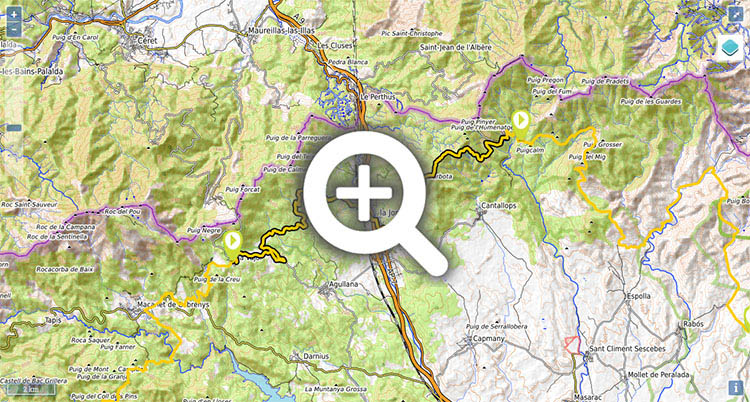
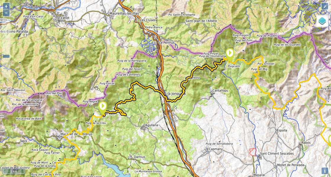
Stage 43: La Vajol - La Jonquera - Requesens.

(0h00min; 0 kms) La Vajol (540m). Cross the village and come out at the GI-501 road towards La Jonquera. Follow it until kilometre 3, where there is a track signposted to Santa Eugènia.
(0h50min; 3,7 kms) Road - Km3 (316m). Follow the track leading to...
(1h30min; 6,9 kms) Santa Eugènia (352m). Pay no attention to the track that climbs to the left, and keep straight on down a gentle descent towards the Torrent de Querols. Further ahead you face a short but tough climb as you continue your walk through evergreen oak and cork oak woodland. Forest fires have left their mark on this area. At the bottom you can make out La Jonquera, and it is downhill all the way there from now on. Your arrival in La Jonquera means a sudden return to urban life, as you are greeted by the AVE high-speed rail tracks and the busy AP7 motorway. The GR11 runs parallel to the motorway for half a kilometre in search of a pedestrian tunnel, which you cross below the road, that takes you to the village.
(3h40min; 14,6 kms) La Jonquera (105m). Once in the village, you cross over to the other side of the river Llobregat and walk down Calle Mayor. When you reach the Town Hall square (Plaza del Ayuntamiento), turn left down Carrer de Sant Miquel – a narrow passage -, then right and finally take the first on the left (Carrer del Migidia). Here you begin the climb to...
(4h35min; 17,6 kms) Santa Llúcia (433m). Just before you get to Santa Llúcia there is a table and a drinking fountain. By the chapel there are a few more tables and a few barbecue grills. You continue to climb up the path past an area of woodland that has been devastated by fire. At the top, you reach an open and largely rocky area, of predominantly scrubland. You leave Puig dels Falgers (760) on your right, then pass the Collet d'en Dutres (774), by the peak La Barbota (780) and begin a short descent to the Coll de l'Auleda (697m), criss-crossed by a forestry track. You cross it and follow the path to the...
(5h55min; 20,9 kms) Coll de les Canals (715m), where you rejoin the track, which you follow on the right on a gentle descent.
(6h50min; 25,2 kms) Vecindario de Requesens (504m). Parking zone, livestock pens, La Mare de Déu church, Can Seferino and “La Cantina”.
In La Vajol, at the entrance to the village as you arrive on the GR11 from Maçanet, it stands the new municipal albergue (Sol Ponent) 10 pax, 2 bathrooms, fridge, microwave, cooking space and a large living room. The price is 15€. Bookings: +34 619 916 611; alberg@lavajol.cat).
Shortly after, on the left hand, Ca la Conxita (+34 972 535 213 / +34 687 296 037; restaurant@calaconxita.com) has rooms, a shop and offers bar/restaurant service. His specialty is the traditional Catalan cuisine.
In La Jonquera there is a large number of hotels and hostels. To the south of the village, next to the La Tortuga shopping centre, and for a reasonable price, we recommend Hotel/Restaurante Font del Pla (//). Standing above La Jonquera you have the Refugio de La Torre De Carmanxel (). It is free of charge and exclusively for the use of CEE members and members of the mountain association. The local police have the keys to the refuge. Most of the hotels and pensions are outside the town centre, in service areas by the motorway.
At the end of the stage, Alojamientos rurales de Requesens (34 646 179 509; info@fincaderequesens.cat; See map). Next to La Cantina (restaurant), it has a kitchen and a fireplace. Contact in advance.
Two kilometres from Requesens, along the GR11, is the Refugi del Forn de Calç (acceptable condition, for around 10 people, "inhabited by the odd mouse").
Where to eat:In La Vajol, Ca la Conxita (//) has a restaurant where you can get breakfast, the set menu or à la carte, as well as seasonal dishes such as “canelloni de calçots”.
In La Jonquera, the Hotel/Restaurante Font del Pla (//) has menus, a buffet plus a varied selection of Catalonian specialities.
In Requesens, you have La Cantina (/) (delicious salads, salamis, canelloni, grilled meat with aioli and typical desserts). You are recommended to book in advance.
Other services:In La Vajol, Ca la Conxita has a little shop selling food and other basic products.
In La Jonquera, there are all kinds of shops, shopping centres (2 kilometres away), supermarkets, etc.