Download the track


Stage 34: Refugio de L'Illa - Refugio de Malniu


Distance/elevation: 14,6 kms / (+760m),(-1.120m)
Time: 5h20min (walking time without stops).
Difficulty: in early summer there could be snow on the Coll de Vallcivera (2,544m) and the Portella d'Engorgs (2,696m).
Water: you will find a number of streams along the way.
Route/Itinerary:

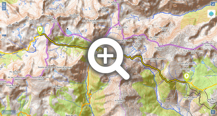
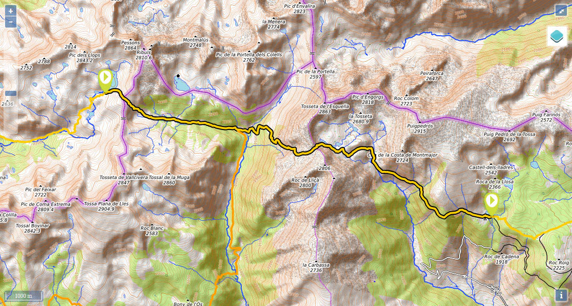
(0h0min;0km) Refugio de l'Illa (2.480m). The path climbs up, behind the refuge, to the Estany de L'Illa dam, passes it on the left and soon comes to a crossing where both the GRP and the GR7 turn left (north) while the GR11 keeps right.

(0h15min; 0.7kms) Coll de Vallcivera (2.544m). You are leaving Andorra and entering Catalonia. On the other side stands Pico de la Muga (2,860m). A sharp descent takes you to Pla de Vallcivera then continues down through the valley. Fields give way to pine trees, as you reach the head of the Valle de la Llosa, where you join the GR107 and the GR11.10 variant. In a field you will see the...

(1h25min; 4.6kms) Cabaña dels Esparvers (2.070m). Carry on ahead (east) along the same route as the GR107 for 200m, as far as a crossing with a signpost. The GR107 heads north to Portella Blanca, while the GR11 turns right, crosses a stream and zigzags up towards the mountain opposite.

(3h10min; 7.8kms) Portella de Calm Colomer o d'Engorgs (2.697m). You head down the other side through rough terrain to Estany de la Portella lake, which you leave on the left, then continue across rocky terrain towards the Estanys dels Minyons lakes, which you also leave on your left. The terrain improves as the path begins the descent, while in the distance you can make out the small d'Engorgs shelter.

(3h45min; 9.9kms) Refugio d'Engorgs o de J. Folch i Girona (2.375m). From this point the GR11 follows the same route as the local 102 path, indicated with yellow markings. Carry on down through the valley (south) and cross the stream (4'). You reach a kind of balcony, which you descend, then continue along the hillside by the south face of Puigpedrós (2,914m). The path eventually peels definitively away from the river and heads into the pine forest, and at times the path can be little unclear. Almost at the end, you come out into some fields, from where you can make out the car par at the refuge and the Estany Sec lake.

(5h20min; 14.6kms) Refugio de Malniu (2.130m). Drinking fountain.

Where to sleep:

At the beginning of the stage, Refugi de L'Illa (/).

During the stage, Cabaña dels Esparvers (not great condition, 3 people) and Refugio d'Engorgs o de J. Folch i Girona (good condition).

At the end of the stage, you have the Malniu mountain refuge (/)

Maps:

- Alpina: Andorra (Scale: 1/40.000).

Transport:

Malniu mountain refuge is accessible by car from Malniu via a forest track (10kms).


Perfil de la etapa

Stages - GR11

- Prologue: Cabo Higuer - Hondarribia - Irun
- Stage 1: Cabo Higuer - Bera
- Stage 1v (GR 11.3): Cabo Higuer - Lesaka
- Stage 2: Bera - Elizondo
- Stage 2v (GR 11.3): Lesaka - Elizondo
- Stage 3: Elizondo - Pto de Urkiaga
- Stage 4: Puerto de Urkiaga - Burguete
- Stage 5: Burguete/Auritz - Villanueva de Aezcoa/Hiriberri
Stage 6: Villanueva de Aezcoa/Hiriberri - Ochagavia
Stage 7: Ochagavia - Isaba
Stage 8: Isaba - Zuriza (via Belabarce)
Stage 8v (GR 11.4): Isaba - Zuriza (via Ezkaurre)
Stage 9: Zuriza - Aguas Tuertas
Stage 10: Aguas Tuertas - Lizara
Stage 10 (discontinued): Aguas Tuertas - Candanchú
Stage 11: Lizara - Candanchú
Stage 12: Candanchú - Sallent de Gallego
Stage 9v (GR 11.1): Zuriza - Puente de Santa Ana
Stage 10v (GR 11.1): Puente de Santa Ana - Lizara
Stage 11v (GR 11.1): Lizara - Canfranc Estación
Stage 12v: Canfranc Estación - Sallent de Gallego (via C.Izas)
Stage 13: Sallent de Gallego - Refugio de Respomuso
Stage 14: Refugio de Respomuso - Balneario de Panticosa
Shortcut: The pipeline path from Bachimaña to Brazato
Stage 15: Balneario de Panticosa - San Nicolas de Bujaruelo
Stage 16: San Nicolas de Bujaruelo - Refugio de Goriz
Stage 17: Refugio de Goriz - Circo de Pineta (Fuenblanca)
Stage 17v (GR11.9): Refugio de Goriz - Circo de Pineta (Faja de las Olas)
Stage 18: Circo de Pineta - Parzán
Stage 19: Parzán - Biadós
Stage 20: Biadós - Puente de San Jaime
Stage 20v (GR 11.2): Biadós - Ref. Ángel Orús
Stage 21v (GR 11.2): Ref. Ángel Orús - Puente de San Jaime
Stage 21: Puente de San Jaime - Refugio de Cap de Llauset
Stage 21v (GR 11.5): Puente de San Jaime - Refugio de la Renclusa
Stage 22v (GR 11.5): Refugio de la Renclusa - Refugio de Cap de Llauset
Stage 22: Ref. Cap de LLauset - Conangles
Stage 23: Conangles - La Restanca
Stage 24v (GR11.18): La Restanca - Colomers
Stage 25: Colomers - Ernest Mallafré
Stage 26: Ernest Mallafré - La Guingueta
Stage 27: La Guingueta - Estaón
Stage 28: Estaón - Tavascán
Stage 29: Tavascán - Areu
Stage 30: Areu - Baiau
Stage 31: Baiau - Arans
Stage 32: Arans - Encamp
Stage 33: Encamp - Ref. l'Illa
Stage 34: Ref. l'Illa - Malniu
Stage 35: Malniu - Puigcerdá
Stage 36: Puigcerdá - Planoles
Stage 37: Planoles - Santuario de Nuria
Stage 38: Santuario de Nuria - Refugio de Ulldeter
Stage 39: Refugio de Ulldeter - Molló
Stage 40: Molló - Talaixà
Stage 41: Talaixà - Albanyà
Stage 42: Albanyà - La Vajol
Stage 43: La Vajol - Requessens
Stage 44: Requessens - Vilamaniscle
Stage 45: Vilamaniscle - El Port de la Selva
Stage 46: El Port de la Selva - Cap de Creus


Selección: GPS de montaña
eTrex Touch 35
eTrex 30x
eTrex 20x


Map of the stage