Download the track


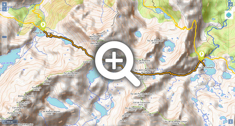
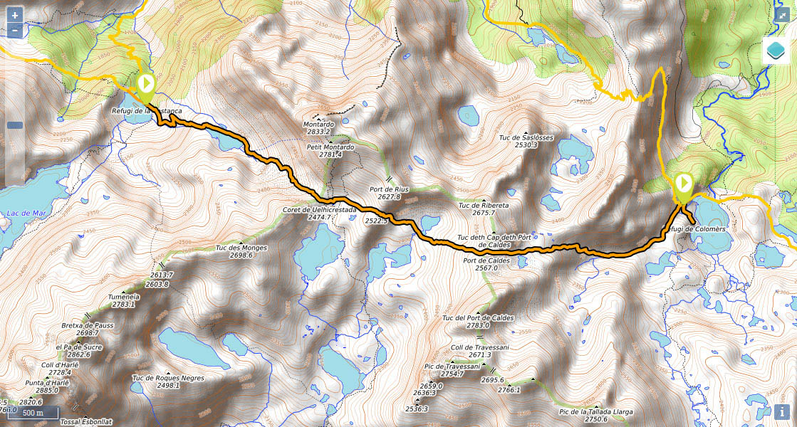
Stage 24 (GR11.18): Refugi dera Restanca - Refugi de Colomèrs


Distance/elevation: 7,1 kms / (+640m),(-510m)
Time: 4h00min (walking time without stops).
Difficulty: a short stage with little elevation. Waymarking is good. In early summer you may come across snow at the highest point, between Port de Oelhacrestada (2,475) and Port de Caldes (2,568m).
Water: you will find the odd stream on the way up to Port de Oelhacrestada and on the descent to Port de Caldes.
Suggestions: follow the main GR11 route. Descend to Rius valley as far as Plan de Nera then climb up to Coll de Ribereta and head down to Colomèrs. This option is mostly by track. If you decide to take the GR11.18 variant, which in our view is more interesting, from Port de Oelhacrestada, you could climb Montardó (2,833m) in 45mins. And if you would like a longer walk, you could continue into the next stage, and head to Obago cabin (4h55min), Ernest Mallafré refuge (8h25min) or off the main route, Amitges refuge (7h40min).
Route/Itinerary:

(0h0min;0km) Refugio dera Restanca (2.010m). Follow the path that climbs up from the refuge (east), while also following the Carros de Foc route. After about 30mins you will reach Cap de Port lake (2,230m), which you follow round on the left, then head up across bumpy terrain to the col that can be seen in the distance.

(1h30min; 2.5kms) Oelhacrestada or Rius Pass (2.475m). At the foot of Montardo (2,833m), those eager enough could take on the climb in 40mins. Just beyond the col, the path splits in two. To the right, towards Estany des Monges, the yellow markings lead down to Carros de Foc. Ahead, on the flat, are the markings for this variant of the GR11. You keep ahead (east) over a shoulder that peels off from Montardo, followed by a sharp drop that takes you to Port de Caldes lake (2,410m). Continue in an easterly direction, towards...

(2h35min; 4.4kms) Port de Caldes (2.568m). The highest point of the stage. You start the descent with the Estanh deth Pòrt de Caldes lake on your right . After another steep drop leaves you at the foot of the valley (Coma deth port de Caldes), you walk ahead, through more confortable terrain, until you reach Lac Major de Colomèrs. Veer right before the dam, then you will reach the new Colomèrs mountain refuge.

(4h00min; 7.1kms) Refugi de Colomèrs (2.115m).

Where to sleep:

At the beginning of the stage, Refugi dera Restanca (/).

At the end of the stage, Refugi de Colomèrs (/). Given that the refuge is accessible from Arán valley (track, taxi service) added to the popularity of the area around the lakes (among the busiest routes in the Pyrenees), we recommend booking at least 1 month in advance during the months of July and August.

Maps:

- Alpina: Parc Nacional d'Aigüestortes i Stany de Sant Maurici (Scale: 1/25.000).
- SUA edizioak: Aigüestortes i estany de Sant Maurici (Scale: 1/25.000).

Transport:

The Park bus (Alsa), completes an almost circular route of the Park through the Boí, Noguera Ribagorçana, Arán and Noguera Pallaresa valleys with 2 daily services in one direction and 2 in the other.

Activities in the area:

One of the best-known excursions is the round trip around the Circo de Colomèrs (waymarked itinerary). In the Aigües Tortes i Estany de Sant Maurici National Park, the Carros de Foc traverse is very popular (a circular route that links all 9 of the National Park’s refuges).


Perfil de la etapa

Stages - GR11

- Prologue: Cabo Higuer - Hondarribia - Irun
- Stage 1: Cabo Higuer - Bera
- Stage 1v (GR 11.3): Cabo Higuer - Lesaka
- Stage 2: Bera - Elizondo
- Stage 2v (GR 11.3): Lesaka - Elizondo
- Stage 3: Elizondo - Pto de Urkiaga
- Stage 4: Puerto de Urkiaga - Burguete
- Stage 5: Burguete/Auritz - Villanueva de Aezcoa/Hiriberri
Stage 6: Villanueva de Aezcoa/Hiriberri - Ochagavia
Stage 7: Ochagavia - Isaba
Stage 8: Isaba - Zuriza (via Belabarce)
Stage 8v (GR 11.4): Isaba - Zuriza (via Ezkaurre)
Stage 9: Zuriza - Aguas Tuertas
Stage 10: Aguas Tuertas - Lizara
Stage 10 (discontinued): Aguas Tuertas - Candanchú
Stage 11: Lizara - Candanchú
Stage 12: Candanchú - Sallent de Gallego
Stage 9v (GR 11.1): Zuriza - Puente de Santa Ana
Stage 10v (GR 11.1): Puente de Santa Ana - Lizara
Stage 11v (GR 11.1): Lizara - Canfranc Estación
Stage 12v: Canfranc Estación - Sallent de Gallego (via C.Izas)
Stage 13: Sallent de Gallego - Refugio de Respomuso
Stage 14: Refugio de Respomuso - Balneario de Panticosa
Shortcut: The pipeline path from Bachimaña to Brazato
Stage 15: Balneario de Panticosa - San Nicolas de Bujaruelo
Stage 16: San Nicolas de Bujaruelo - Refugio de Goriz
Stage 17: Refugio de Goriz - Circo de Pineta (Fuenblanca)
Stage 17v (GR11.9): Refugio de Goriz - Circo de Pineta (Faja de las Olas)
Stage 18: Circo de Pineta - Parzán
Stage 19: Parzán - Biadós
Stage 20: Biadós - Puente de San Jaime
Stage 20v (GR 11.2): Biadós - Ref. Ángel Orús
Stage 21v (GR 11.2): Ref. Ángel Orús - Puente de San Jaime
Stage 21: Puente de San Jaime - Refugio de Cap de Llauset
Stage 21v (GR 11.5): Puente de San Jaime - Refugio de la Renclusa
Stage 22v (GR 11.5): Refugio de la Renclusa - Refugio de Cap de Llauset
Stage 22: Ref. Cap de LLauset - Conangles
Stage 23: Conangles - La Restanca
Stage 24v (GR11.18): La Restanca - Colomers
Stage 25: Colomers - Ernest Mallafré
Stage 26: Ernest Mallafré - La Guingueta
Stage 27: La Guingueta - Estaón
Stage 28: Estaón - Tavascán
Stage 29: Tavascán - Areu
Stage 30: Areu - Baiau
Stage 31: Baiau - Arans
Stage 32: Arans - Encamp
Stage 33: Encamp - Ref. l'Illa
Stage 34: Ref. l'Illa - Malniu
Stage 35: Malniu - Puigcerdá
Stage 36: Puigcerdá - Planoles
Stage 37: Planoles - Santuario de Nuria
Stage 38: Santuario de Nuria - Refugio de Ulldeter
Stage 39: Refugio de Ulldeter - Molló
Stage 40: Molló - Talaixà
Stage 41: Talaixà - Albanyà
Stage 42: Albanyà - La Vajol
Stage 43: La Vajol - Requessens
Stage 44: Requessens - Vilamaniscle
Stage 45: Vilamaniscle - El Port de la Selva
Stage 46: El Port de la Selva - Cap de Creus


Selección: GPS de montaña
eTrex Touch 35
eTrex 30x
eTrex 20x


Map of the stage